

Today’s Forecast:
The final week of October will begin on a warm and windy note, with a Red Flag Warning in effect for parts of Southern Colorado from noon until 6 pm. Today's Red Flag Warnings will include both Colorado Springs and Pueblo.

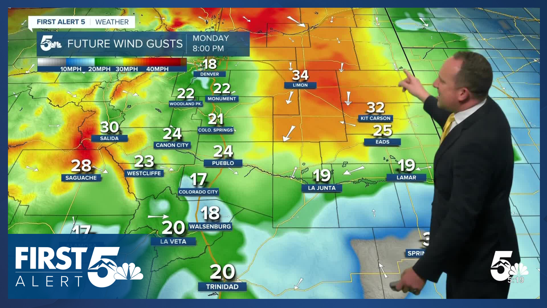
With gusts around 25-35 mph expected this afternoon, highs today will be well above average for this time of the year. Highs on the Plains will climb into the 60s and 70s. Any snow that we see from today's storm should stick to the central and northern mountains. Any rain that we see today will generally favor northern Colorado, with a shower or two possible this evening along and east of the Palmer Divide.
Colorado Springs forecast: High: 71; Low: 29. Our work week will begin on a warm and gusty note, with afternoon wind gusts up around 30 mph. This has prompted a Red Flag Warning today for Colorado Springs, in effect from noon until 6 pm.
Pueblo forecast: High: 76; Low: 30. Warm and windy on Monday, with highs today around 10 degrees above seasonal averages. Driven by wind gusts to 35 mph, a Red Flag Warning will remain in effect today from noon until 6 pm.
Canon City forecast: High: 73; Low: 34. Strengthening westerly winds on Monday will bring unseasonably warm highs in the lower to middle 70s to eastern Fremont County, with peak gusts today up around 35 mph.
Woodland Park forecast: High: 59; Low: 19. A mild and windy start to the week can be expected across Teller County on Monday, with peak gusts to 35 mph. This evening, there could be a few flurries near the mountains, with minimal impacts as most of the moisture should stay to our north.
Tri-Lakes forecast: High: 60s; Low: 20s. A mild and windy Monday will give way to a cold night as lows this evening drop down to the 20s. While most of the moisture will stay to our north today, we can't rule out a few flurries or a shower this evening.
Plains forecast: High: 60s/70s; Low: 30s. Warm and windy on Monday, with highs today well into the 70s. As a cold front arrives this evening, the wind will shift from the west to the north, and it will remain gusty. There could also be a few showers this evening on the High Plains.
Walsenburg and Trinidad forecast: High: 60s/70s; Low: 20s/30s. Strengthening wind this afternoon will bring the potential for westerly wind gusts to 35 mph to some areas. This will drive up temperatures today, with many areas landing in the 70s.
Mountains forecast: High: 40s; Low: 20s. Our state's southeastern mountains will remain on the windy side of today's storm, with any snow expected to stay mainly north of I-70. Gusts in our local mountains this afternoon could top 40 mph in some areas.
Extended outlook forecast:
Behind tonight's cold front will come a dramatic mid-week cool down. Highs on Tuesday in Colorado Springs will only warm into the upper 40s, with a low of near 20 degrees Tuesday night. This will be our first hard freeze of the season for many areas, so take precautions ahead of time to protect pets, pipes and plants.
Highs will rebound into the lower 50s on Wednesday and lower 60s by Thursday in Colorado Springs. A weak front on Friday will cool us down to the upper 50s. Halloween night will be in the 40s for Trick or Treating across the Pikes Peak Region. Highs will warm this weekend as high pressure builds towards Colorado. Sunday afternoon will be a warm one, topping out in the 70s for the Plains.
____
Curious about the First Alert 5 Weather Storm Impact Scale? Check out our cheatsheet explainer.
Watch KOAA News5 on your time, anytime with our free streaming app available for your Roku, FireTV, AppleTV and Android TV. Just search KOAA News5, download and start watching.
