

Today’s Forecast:
Today is the 10th day with Red Flag Warnings in some portion of southern Colorado so far this March. March is one of the busier months of the year for fire danger in southern Colorado, but even by that standard -this is a lot-. We average about 7.5 Red Flag Warning days per month in the month of March somewhere in southern Colorado, and we've only halfway through the month.
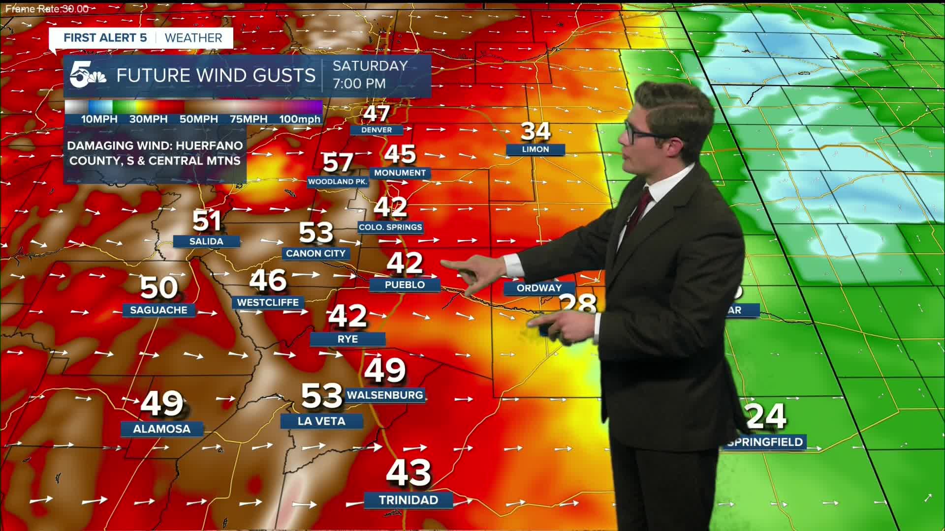
Strong northwesterly flow in the upper levels of the atmosphere continue to drive over the state today, with that wind mixing down through much of the day. Today's wind will be the strongest you've felt this week - with gusts of 40-55+ mph this afternoon across the southeastern plains and southern mountains. Today's Red Flag Warnings will be in effect from 11:00 AM - 10:00 PM. This is a critical, to - in some zones - extreme fire weather threat for southeastern Colorado and should be treated accordingly.
We've also been tracking sporadic air quality issues. An air quality alert is in effect through 9:00 AM this morning for the lower Arkansas River Valley, including Pueblo County, and parts of the southeastern plains due to wildfire smoke. This smoke is coming from out of state fires in Nebraska: not from Colorado. That said, if you do see thick smoke this afternoon, call 911. So far, southern Colorado has done well at keeping fire threats at bay despite high risks. The best way to help emergency officials and our community if one does start, is letting them know as fast as possible.
What the fast-growing fires in Nebraska illustrate is why it remains so important to avoid outdoor burning, and any other activities that could spark a wildfire.
Highs today will be in the middle 70s in the Pikes Peak Region, and 80s across the plains which will be near or at records. Today's record high is 75 in Colorado Springs, and 83 in Pueblo.
The timing of strongest wind is highly location dependent.
*This MORNING: Gusts are strongest in Teller County, S. Mtns, gap flow zones (Huerfano County, areas E. of La Veta Pass)
*This AFTERNOON: Everywhere is windy. Strongest winds still in the mountains, but mix down into upper Arkansas River Valley as well (Canon City, Pueblo West, Penrose, Pueblo).
*This EVENING: Stronger gusts in the Pikes Peak Region.
*SUNDAY: The plains, east of I-25, following a cold front.
It will be gusty for everyone this weekend - this is just the timing of the strongest wind.
11AM Update:
High Wind Warnings have now been issued for most of the plains - High Wind Watches have been upgraded. See the zones below for timing.
Colorado Springs forecast: High: 75; Low: 26.
HIGH WIND WARNING in effect from 12:00 AM SUNDAY - 7:00 PM SUNDAY
RED FLAG WARNING in effect 11:00 AM - 10:00 PM
Initially decreasing clouds (mid-level, lenticular), followed by increasing clouds in the mid afternoon. Increasing wind out of the west - at 10-15 mph this morning, increasing to 20-30 mph this afternoon, gusting to 50 mph by mid to late afternoon.
A cold front blasts south sometime between 12:00 -2:00 AM. I lean closer to 12:00 AM because fronts traveling south across the plains gain speed and typically outpace the models. It's a roof rumbler - wind 40+ mph, and a fast drop in temps behind it. A quick shot of wind-blown snow is possible too overnight. Accumulations, if any, would be minor; expect temporary reductions to visibility.
Pueblo forecast: High: 81; Low: 30.
HIGH WIND WARNING in effect from 12:00 AM SUNDAY - 7:00 PM SUNDAY
RED FLAG WARNING in effect 11:00 AM - 10:00 PM
Mostly sunny, and feeling like May, with high to extreme fire danger developing. West southwest winds at 10-15 mph this AM, ramping up to 25-35 mph this afternoon, gusting to 55 mph this afternoon. Be prepared for pockets of blowing dust. If you're caught in blowing dust and you're driving, treat it like a blizzard or snow squall: pull over when and where you can safely do so, and wait for visibility to improve before proceeding. Fire danger will still be high after sunset.
Wave clouds develop mainly to your east later in the afternoon. A cold front will blast through in the 1:00 AM -3:00 AM time frame.
Canon City forecast: High: 77; Low: 33.
RED FLAG WARNING in effect 11:00 AM - 10:00 PM
Mostly sunny with plenty of wind on the way. West winds, 10-15 mph gusting to 25 mph this morning. In the afternoon, sustained winds will bump to 25-35 mph, gusting to 55 mph. Be prepared for pockets of blowing dust, particularly along U.S. 50. If you're caught in blowing dust and you're driving, treat it like a blizzard or snow squall: pull over when and where you can safely do so, and wait for visibility to improve before proceeding. Fire danger will still be high after sunset.
It stays gusty tonight.
Woodland Park forecast: High: 62; Low: 14.
RED FLAG WARNING in effect 11:00 AM - 10:00 PM
Mostly sunny and very windy - in wind prone areas (you likely already know if you're in one of them or if you're sheltered by terrain). West winds, 10-20 mph this morning, gusting to 40 mph. This afternoon, west southwest wind at 35-40 mph, gusting 50-60 mph this afternoon.
Tri-Lakes forecast: High: 70s; Low: Teens.
HIGH WIND WARNING in effect from 12:00 AM SUNDAY - 7:00 PM SUNDAY
RED FLAG WARNING in effect 11:00 AM - 10:00 PM
Partly sunny with increasing southwesterly winds. This morning at 10-15 mph increasing to 20-30 mph gusting to 45 mph this afternoon.
A cold front arrives tonight, and a brief period of snow is likely early Sunday morning. Accumulations of 1-2" - minor - but strong wind gusts will lead to periodic low visibility into Sunday along the Palmer Divide.
Plains forecast: High: 70s/80s; Low: 20s.
HIGH WIND WARNING in effect from 12:00 AM SUNDAY - 7:00 PM SUNDAY
RED FLAG WARNING in effect 11:00 AM - 10:00 PM
Mostly sunny and -hot- for this time of year, southwest winds at 10-20 mph gusting to 35 mph at times today. The further west you are, the stronger your afternoon wind gusts. Damaging wind is possible tonight. Secure loose outdoor items. Gusts to 70 mph are possible early Sunday.
Walsenburg and Trinidad forecast: High: 76/77; Low: 29/26.
HIGH WIND WARNING in effect from 6:00 PM SATURDAY - 3:00 PM SUNDAY for Walsenburg
HIGH WIND WARNING in effect from 12:00 AM SUNDAY - 7:00 PM SUNDAY for Trinidad
RED FLAG WARNING in effect 11:00 AM - 10:00 PM
Mostly sunny with west winds at 10-15 mph increasing to 25-35 mph this afternoon and gusting to 55 mph. Winds increase further tonight, with a High Wind Warning in effect beginning at 6:00 PM. Secure loose outdoor items, and be prepared for pockets of blowing dust.
Mountains forecast: High: 60s; Low: 20s.
HIGH WIND WARNING in effect from 6:00 PM SATURDAY - 3:00 PM SUNDAY
RED FLAG WARNING in effect 11:00 AM - 10:00 PM
Mostly sunny and windy with west winds at 10-15 mph gusting to 35 mph this morning increasing to 20-30 mph gusting to 55 mph this afternoon. Winds get stronger tonight with a high wind warning beginning at 6:00 PM. Secure loose outdoor items.
Extended outlook forecast:
A cold front will blast south through southern Colorado late tonight and we're in for a serious case of weather whiplash. This roof rumbler blasts through the plains between midnight and 2 AM and comes with plenty of wind, and a dramatic and rapid drop in temperatures. Sustained winds of 30-40 mph are possible with the front, with stronger gusts. High Wind Watches are in place Sunday across the plains.
We'll track very light snow behind the front early Sunday morning, with the best potential for anything notable over the Palmer Divide due to the northerly flow. Although accumulations will be low - possibly up to 1", visibility will be a problem due to the gusty wind accompanying any snow. Expect periodic visibility issues over the Palmer Divide on Sunday.
A dramatic case of weather whiplash comes courtesy of the front - with highs Sunday down by about 40 degrees across the area! With the strong wind, it'll feel like the 20s to the teens!
Then, the roller coaster reaches the base of our next - and year to date tallest hill - and we begin clanking up the track. Monday is quiet and mild with highs in the upper 50s/low 60s. It's a great outdoor day if you've got it open on your calendar.
And then comes a record-busting ridge of high pressure. Highs in the 70s Tuesday, with 80s Wednesday-Friday, with 90s likely across parts of the plains. It is difficult to overstate the potency, and unprecedented nature, of this ridge. 90 is possible in Pueblo. 105+ is possible in Phoenix. 60s in the high mountains.
____
Curious about the First Alert 5 Weather Storm Impact Scale? Check out our cheatsheet explainer.
Watch KOAA News5 on your time, anytime with our free streaming app available for your Roku, FireTV, AppleTV and Android TV. Just search KOAA News5, download and start watching.
