Tonight's Forecast: We'll see increasing clouds tonight ahead of a fast-moving storm that moves into Southern Colorado on Monday. Dry weather will persist through Monday morning east of the mountains. Areas along the Continental Divide will see an increasing chance of snow showers after midnight.
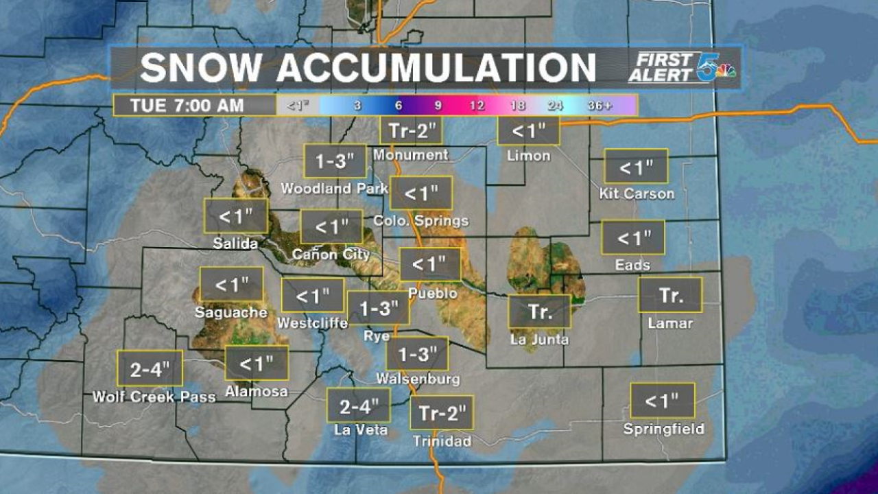
COLORADO SPRINGS: Low: 26; High: 45. Dry skies Monday morning will give way to an afternoon mix of rain and snow, followed by light snow showers tomorrow night. Snow totals less than 1".
PUEBLO: Low: 24; High: 49. An active start to the week on Monday, with a fast-moving system bring rain showers to the forecast by the afternoon. Rain will likely to turn to snow by the evening. Snow totals less than 1".
CANON CITY: Low: 32; High: 49. Monday morning will start out dry, with a rain/snow mix developing by the afternoon. Rain will likely turn to snow around sunset. Snow totals less than 1".
WOODLAND PARK: Low: 25; High: 40. Snow showers in the morning will give way to steadier snow for the afternoon and evening hours. It's a fast-moving system, so totals will be fairly light, generally from 1-3".
TRI-LAKES: Low: 20s; High: 40s. Dry skies for the morning hours, with increasing chances for snow by the afternoon and evening. Caution should be exercised traveling over the Palmer Divide tomorrow evening as roads could turn slick and icy. Snow totals from a trace to 2".
PLAINS: Low: 20s; High: 40s/50s. A chilly and dry start to the day for the Plains will turn wet with rain for the afternoon, with snow mixing in by tomorrow night. Snow totals well under 1".
WALSENBURG/TRINIDAD: Low: 20s/30s; High: 40s/50s. Periods of rain and snow will return to the forecast by Monday afternoon. Rain will likely turn to snow after sunset. Snow totals from a trace to 2" for Trinidad, and 1-3" for Walsenburg.
Extended Outlook: Dry skies on Tuesday with a break in the action before another storm moves into Southern Colorado on Wednesday. While this next storm looks colder, I don't see it bringing anything more than minor to moderate impacts to our forecast. Light snow accumulations will be possible for Colorado Springs and Pueblo Wednesday evening, with a few inches or more for Canon City and Woodland Park.