


Tonight's Forecast:
A round of rain and snow will push into Southern Colorado tonight. The heaviest bands of precipitation will be over the Pikes Peak Region and Raton Mesa. Snow levels will lower to 6,500 to 7,000 feet by early Monday morning, with a few slushy inches of snow possible in Teller County and the Palmer Divide. Be prepared for possible driving impacts in these areas, and give yourself some extra time to get to work.
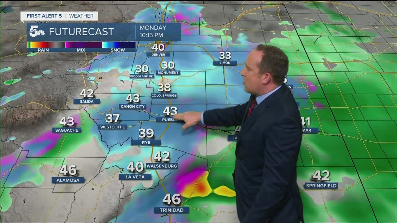
COLORADO SPRINGS: Low: 35; High: 45. Cold and unsettled weather to start the week across the Pikes Peak Region. The first part of our Monday should be relatively dry. Rain will pick up by mid to late afternoon before changing to snow Monday night. As snow levels drop down to around 6,000 feet, a few inches of accumulation can be expected throughout town, especially higher elevation neighborhoods.
PUEBLO: Low: 40; High: 50. More beneficial moisture is expected to move into Pueblo County over the next 24 to 48 hours. It comes in two rounds. The first will bring rain to the forecast tonight into Monday morning. The next round will be heavier, with rain and possible snow from late Monday afternoon into Tuesday morning.
CANON CITY: Low: 40; High: 50. After some overnight and early morning rain showers, our weather will be dry most of the day on Monday before the next round of wet weather moves in late Monday afternoon. Rain will be heavy at times through Tuesday morning, with snow mixing in at times during the overnight hours.
WOODLAND PARK: Low: 29; High: 40. Look for a few inches of snow to fall over Teller County through Monday morning, with the potential for slick and snow covered roads in some areas. The more impactful round of wintry weather will push into the forecast late Monday afternoon, with periods of heavy snowfall through Tuesday morning. Snow totals of 4-8" will be possible.
TRI-LAKES: Low: 30s; High: 40s. A round of rain and snow will impact northern El Paso County through Monday morning, with an inch or two of accumulation possible. A bigger push of moisture will arrive late Monday afternoon, with the potential for heavy snowfall through Tuesday morning.
PLAINS: Low: 30s/40s; High: 40s/50s. Overnight rain showers will taper off by Monday morning. The next round of rain and thunderstorms is expected to arrive later in the day on Monday, with more beneficial moisture for the Plains.
WALSENBURG/TRINIDAD: Low: 30s/40s; High: 50s. Rain showers and isolated thunderstorms tonight will come to an end pretty early Monday. A second round of rain pushes into the forecast later in the day on Monday, with snow mixing in during the overnight hours.
MOUNTAINS: Low: 10s/20s; High: 30s/40s. Periods of snow and cold temperatures will impact the mountains through Tuesday. The heaviest snowfall is expected from Monday afternoon through Tuesday morning, with totals over 6" in many areas before the storm pulls away late Tuesday and Wednesday.
Extended Outlook:
Most of the precipitation will come to an end by Tuesday morning, with only lingering rain and snow showers continuing through Tuesday evening. As the storm system moves away from Southern Colorado on Wednesday, we warm, but also welcome the chance for scattered afternoon showers and thunderstorms. From Thursday through the weekend, we'll gladly welcome back dry and warmer weather, with only isolated afternoon thunderstorms possible.
KOAA News5 on your time, streaming on your Roku, FireTV, AppleTV and AndroidTV.
News5 App | First Alert 5 Weather App | Youtube | Facebook | Instagram | Twitter
