


Tonight's Forecast:
After seeing high fire danger this afternoon over the Raton Mesa and our southern counties, we should see a brief lull in the winds this evening along with rising relative humidity values. After midnight, snow is likely to develop near the Continental Divide as strong gusts also build into the mountains. This region of stronger winds will expand farther east by Tuesday morning, impacting the I-25 corridor and the Plains.
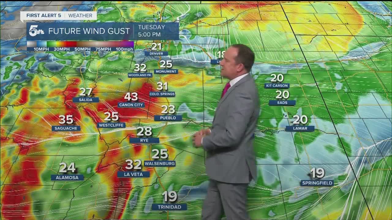
COLORADO SPRINGS: Low: 43; High: 65. Mostly sunny and cooler on Tuesday, with strong wind gusts to 35 mph possible from late morning through early evening. A Red Flag Warning will go into effect at noon and continue until 7 pm.
PUEBLO: Low: 41; High: 72. High fire danger is expected for Pueblo County on Tuesday due to gusty winds, low relative humidity and dry vegetation. Temperature wise...a cold front will bring us a good 10 degrees of cooling compared to today.
CANON CITY: Low: 44; High: 67. Dry, cooler and windy during the day on Tuesday. High fire danger will be the big story with a Red Flag Warning set to go into effect in Fremont County at noon.
WOODLAND PARK: Low: 34; High: 51. Cool and windy on Tuesday across Teller County, with peak wind gusts up near 40 mph.
TRI-LAKES: Low: 30s/40s; High: 50s/60s. Windy and cooler, but with enough moisture in the air that we should steer clear of Red Flag Warnings.
PLAINS: Low: 40s/50s; High: 70s. A morning cold front will bring 5-10 degrees of cooling to our forecast on Tuesday, but also a lot of strong wind. The result will be high fire danger and Red Flag Warnings that will go into effect at noon.
WALSENBURG/TRINIDAD: Low: 30s/40s; High: 60s. Strong winds that develop tonight across the I-25 corridor will continue into the day on Tuesday as Red Flag Warnings are set to commence at noon.
MOUNTAINS: Low: 20s; High: 40s. A windy 12-24 hours for the mountains of Southern Colorado, with peak gusts as high as 50 mph. A disturbance that moves along the Colorado/Wyoming border on Tuesday will also bring snow towards the Continental Divide, with a few inches of accumulation possible through Tuesday evening. The highest totals will be across northern parts of the state.
Extended Outlook:
Behind Tuesday's storm will come the potential for freezing temperatures Wednesday morning for a large part of Southern Colorado, and a hard freeze for the mountains and mountain valleys. Wednesday afternoon will be pleasant, with seasonal temperatures. A ridge of high pressure will build back into the forecast late this week and weekend, which should keep us dry and warmer than average.
KOAA News5 on your time, streaming on your Roku, FireTV, AppleTV and AndroidTV.
News5 App | First Alert 5 Weather App | Youtube | Facebook | Instagram | Twitter
