

Tonight's Forecast:
A few showers and thunderstorms will linger in the Pikes Peak region, especially El Paso County, through about 10 pm. Overnight, low clouds will form in the plains. Overnight lows will be chilly and near average.
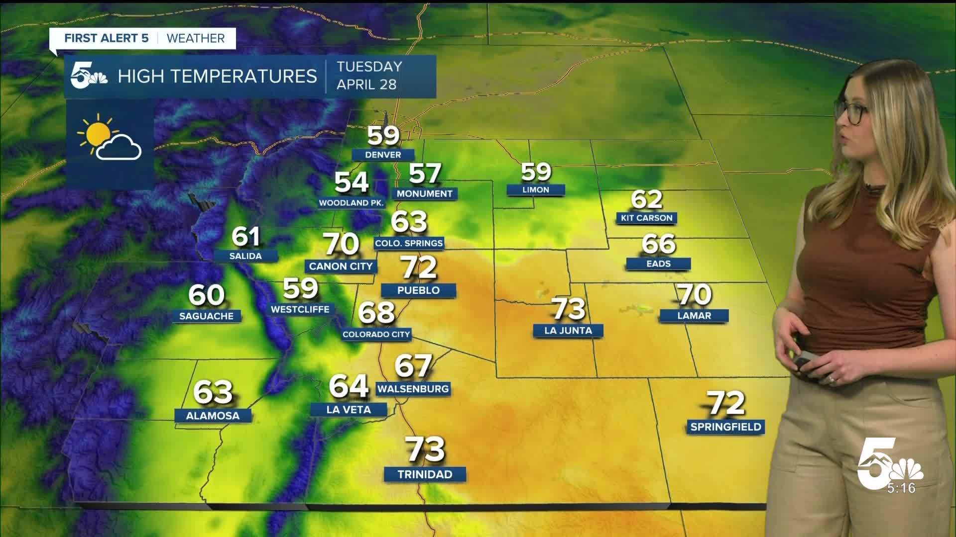
Colorado Springs forecast: Low: 35; High: 63;
It will be partly cloudy on Tuesday with a low chance of a quick afternoon shower. Wind will be out of the SSE at 10 mph, gusting to 20 mph.
Pueblo forecast: Low: 37; High: 72;
It will be partly cloudy with mild temperatures on Tuesday. Wind will be out of the S at 10 mph gusting to 30 mph.
Canon City forecast: Low: 37; High: 70;
It will be mostly sunny to partly cloudy on Tuesday. Wind will be out of the W at 10-15 mph, gusting to 30 mph.
Woodland Park forecast: Low: 28; High: 54;
Tuesday will be partly cloudy with a low chance of an afternoon rain shower. Wind will be out of the W at 10-15 mph, gusting to 30 mph.
Tri-Lakes forecast: Low: 33; High: 57;
Tuesday will be partly cloudy with a spotty rain shower possible in the afternoon. Wind will be out of the WSW at 10 mph gusting to 25 mph.
Plains forecast: Low: 30s; High: 60s-70s;
It will be cloudy in the morning, then sunny in the afternoon. The wind will be out of the SW at 10 mph, gusting 20-30 mph.
Walsenburg and Trinidad forecast: Low: 33/34; High: 67/73;
It will be a breezy Tuesday with partly cloudy conditions. Wind will be out of the WSW at 15 mph, gusting 25-30 mph.
Mountains forecast: Low: 20s-30s; High: 50s-60s;
The San Luis Valley will be under a RED FLAG WARNING from noon until 7 pm on Tuesday for humidity below 15% and wind gusts to 40 mph. The rest of the mountain valleys will not be dry enough for a warning for fire danger, but it will be quite breezy with W wind at 15 mph gusting 30-40 mph.
Extended outlook forecast:
Looking ahead, the weather will bring a nice Spring soaker to southern Colorado for the latter half of the week. On Wednesday, spotty afternoon rain showers and thunderstorms are expected. Widespread showers take over the region on Thursday, with a cloudy and chilly wet day expected. There will be a transition to snow in the mountains down to 7,000 feet (perhaps as low as 6,000 feet) on Thursday night into Friday morning. Showers will slowly taper off on Friday.
____
Curious about the First Alert 5 Weather Storm Impact Scale? Check out our cheatsheet explainer.
Watch KOAA News5 on your time, anytime with our free streaming app available for your Roku, FireTV, AppleTV and Android TV. Just search KOAA News5, download and start watching.
