


Tonight's Forecast:
After a good deal of sunshine and snowmelt this afternoon, it will be a cold night across Southern Colorado. With overnight lows cooling down to the 10s and 20s, some of that melted snow will re-freeze and could lead to a slick commute in some areas. Be especially careful driving over bridges and overpasses as they tend to freeze the quickest.
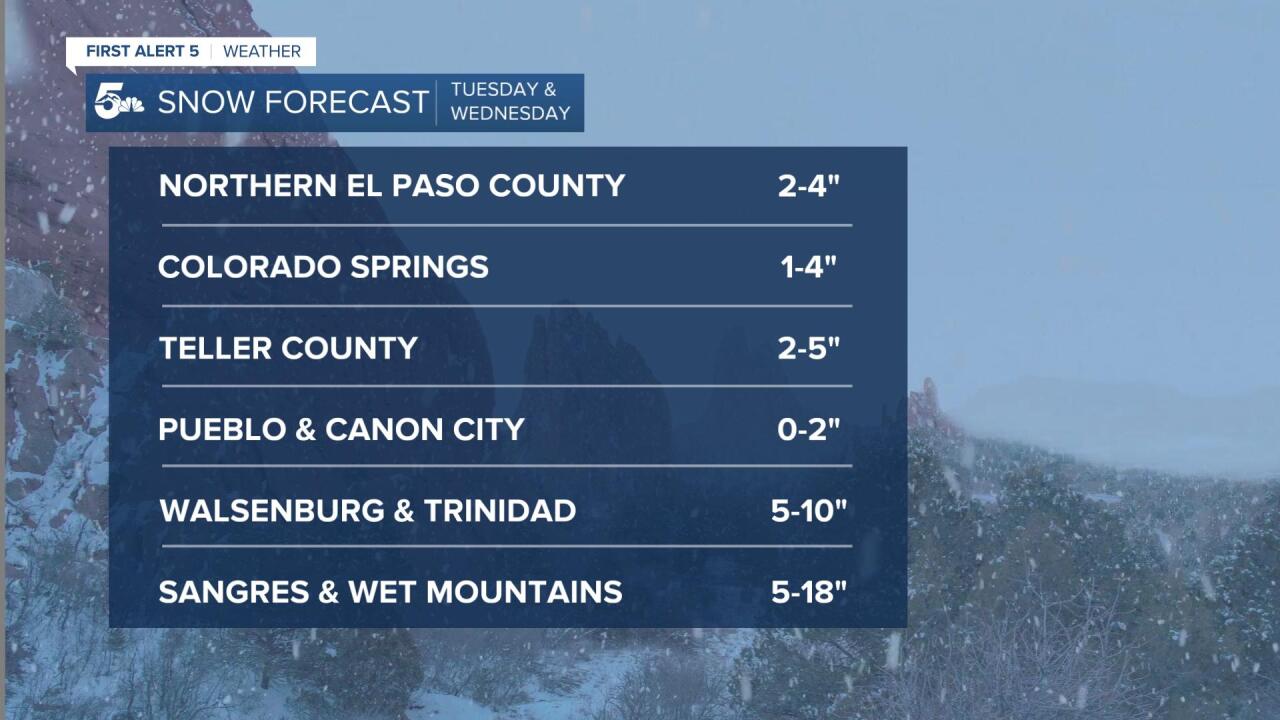
COLORADO SPRINGS: Low: 24; High: 40. Dry skies early will give way to increasing moisture by the afternoon. Snow is likely to pick up between 4-7 pm, with a few inches of accumulation through Wednesday morning.
PUEBLO: Low: 25; High: 46. Mostly sunny skies early will give way to increasing clouds by the afternoon ahead of our next storm. We'll likely start out as rain before transitioning to snow Tuesday night. Snow totals from 0-2".
CANON CITY: Low: 29; High: 45. Dry and mostly sunny early before our next winter storm arrives. Rain and snow showers will increase by late afternoon before tapering off very early Wednesday. Snow totals from 1-2".
WOODLAND PARK: Low: 18; High: 35. Cold in the morning, with icy spots possible on some streets. By mid to late afternoon, the snow is back, with the potential for snow showers through early Wednesday morning. Snow totals from 2-5".
TRI-LAKES: Low: 10s; High: 30s. With many side streets still covered in snow from the weekend blizzard, some areas will still be dealing with snow and ice during the morning commute. Our next round of snow develops by the evening, with 2-4" possible by Wednesday morning.
PLAINS: Low: 20s; High: 50s. The Plains will be nice and mild on Tuesday ahead of our next late winter storm. Rain showers will increase by the evening before turning to snow late Tuesday night. Snow totals will be highest over the southeast Plains, with 3-6" possible for Springfield.
WALSENBURG/TRINIDAD: Low: 20s; High: 40s. We'll see mid to upper 40s Tuesday afternoon ahead of our next winter storm. This storm will heavily favor areas south of Highway 50, with heavy snow likely Tuesday night through early Wednesday morning. Snow totals from 5-10".
MOUNTAINS: Low: 10s/20s; High: 20s/30s. Snow will return to the mountains, and quite a bit is expected on Tuesday. Snow totals from 5-10" will be possible for the Wet Mountains, with 10-18" of fresh snowfall for the Sangres.
Extended Outlook:
Other than some lingering snow showers over the southeast Plains Wednesday morning, the storm should clear out pretty early in most places. Here's a look at how much snow we expect to see from the storm.
It will be windy behind the storm on Wednesday and cool, with highs only warming into the 30s and 40s. Spring-like weather is set for a comeback late this week, with highs climbing all the way into the 50s and 60s by Friday.
KOAA News5 on your time, streaming on your Roku, FireTV, AppleTV and AndroidTV.
News5 App | First Alert 5 Weather App | Youtube | Facebook | Instagram | Twitter
