

Tonight's Forecast:
Winds will begin to increase in the mountains tonight. A HIGH WIND WARNING will go into effect at 11 pm Monday night for Walsenburg, West-central Fremont County, the Wet Mountain Valley, Wet Mountains, Sangre De Cristo Mountains, and El Paso County. It will go into effect at 2 am in the San Luis Valley, including Alamosa. The rest of the region will go into effect at 7 am.

A RED FLAG WARNING will go into effect on Tuesday morning at 10 am and expire at 7 pm.

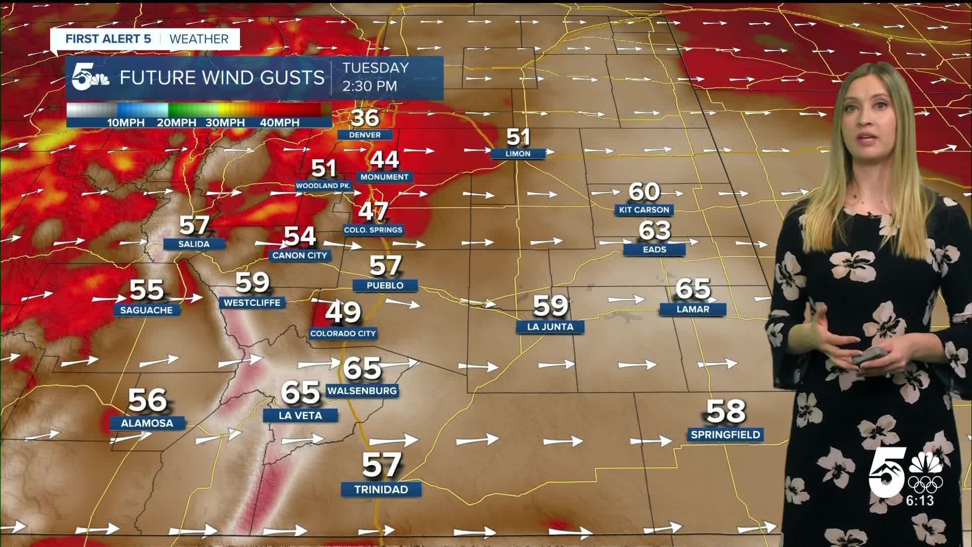
Colorado Springs forecast: Low: 37; High: 58;
HIGH WIND WARNING from 11 pm Monday until 2 pm Tuesday. RED FLAG WARNING from 10 am until 7 pm Tuesday. Wind will be out of the W at 15-25 mph gusting up to 60 mph. Temperatures will be mild, and the sky will be partly cloudy.
Pueblo forecast: Low: 37; High: 62;
HIGH WIND WARNING from 7 am until 6 pm. RED FLAG WARNING from 10 am until 7 pm Tuesday. It will be partly cloudy and mild on Tuesday. Wind will be out of the W at 20-30 mph gusting to 65 mph.
Canon City forecast: Low: 41; High: 60;
HIGH WIND WARNING from 7 am until 6 pm. Wind will be out of the W at 20-30 mph gusting to 65 mph. It will be partly cloudy and mild on Tuesday.
Woodland Park forecast: Low: 30; High: 45;
A burst of snow is possible in the morning, with a few light flurries possible in the afternoon. It will be windy on Tuesday with WSW wind at 20-30 mph gusting to 60 mph.
Tri-Lakes forecast: Low: 35; High: 51;
HIGH WIND WARNING from 11 pm Monday until 2 pm Tuesday. RED FLAG WARNING from 10 am until 7 pm Tuesday. Wind will be out of the W at 15-25 mph gusting up to 60 mph.
Plains forecast: Low: 30s-40s; High: 50s-70s;
HIGH WIND WARNING from 7 am until 6 pm. RED FLAG WARNING from 10 am until 7 pm Tuesday. Winds will be strong out of the W at 15-30 mph, gusting up to 65 mph.
Walsenburg and Trinidad forecast: Low: 44/40; High: 54/58;
HIGH WIND WARNING from 7 am until 6 pm for Trinidad and Las Animas County. HIGH WIND WARNING from 11 pm Monday until 6 pm Tuesday for Walsenburg and Huerfano County. RED FLAG WARNING from 10 am until 7 pm Tuesday.
Mountains forecast: Low: 20s-30s; High: 40s;
HIGH WIND WARNING in effect from 2 am until 6 pm Tuesday for the San Luis Valley. HIGH WIND WARNING in effect from 11 pm Monday until 6 pm Tuesday for the Wet Mountains and Wet Mountain Valley and the Sangre De Cristo Mountains. Wind will be out of the W at 25-35 mph, gusting 65-85 mph. Spotty snow showers are also possible, especially in the morning, where brief heavy bursts are possible.
Extended outlook forecast:
It will remain gusty and dry on Wednesday with fire weather watches issued. A gusty cold front comes in on Thursday, which will drop temperatures to the 30s and 40s across the region.
____
Curious about the First Alert 5 Weather Storm Impact Scale? Check out our cheatsheet explainer.
Watch KOAA News5 on your time, anytime with our free streaming app available for your Roku, FireTV, AppleTV and Android TV. Just search KOAA News5, download and start watching.
