

Tonight's Forecast:
Current red flag warnings expire at 10 pm. Air quality alerts due to wildfire smoke remain in effect until at least 9 am Thursday, but will likely be extended.

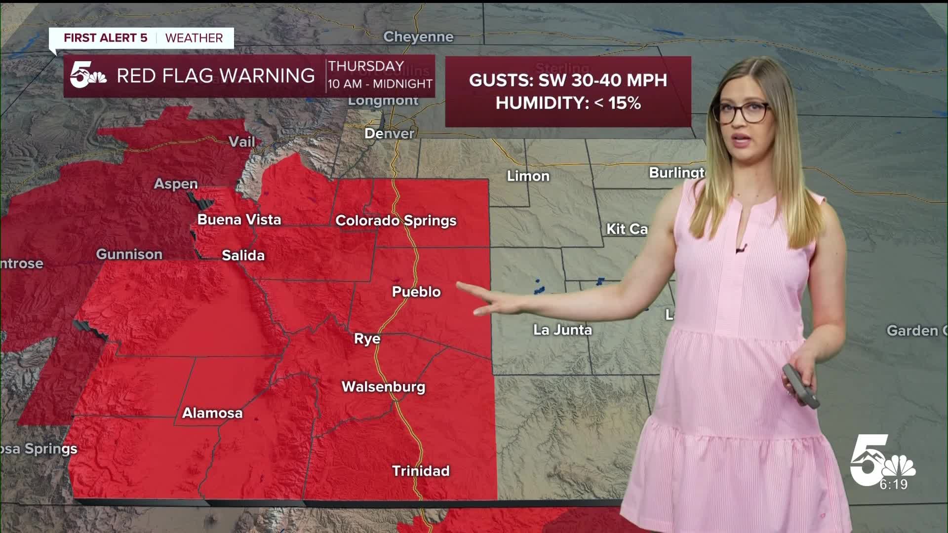
Fire Danger Thursday:
On Thursday, RED FLAG WARNINGS are in effect from 10 am until midnight for the zones highlighted in red. Humidity will drop below 15%, and winds will gust 30-40 mph.

Colorado Springs forecast: Low: 56; High: 92;
RED FLAG WARNING from 10 am until midnight. AIR QUALITY ALERT until at least 9 am. It will be sunny with smoke in the sky on Thursday. Wind will be out of the SW at 10 mph gusting to 20-30 mph.
Pueblo forecast: Low: 58; High: 99;
RED FLAG WARNING from 10 am until midnight. AIR QUALITY ALERT until at least 9 am. It will be hot with a sunny yet smoke-filled sky. Wind will be out of the WSW at 10 mph gusting to 20-30 mph.
Canon City forecast: Low: 58; High: 96;
RED FLAG WARNING from 10 am until midnight. AIR QUALITY ALERT until at least 9 am. It will be sunny and hot with WSW wind at 10-15 mph gusting to 20-30 mph.
Woodland Park forecast: Low: 48; High: 81;
RED FLAG WARNING from 10 am until midnight. AIR QUALITY ALERT until at least 9 am. Another sunny and warm day with WSW wind at 10-15 mph gusting to 30 mph.
Tri-Lakes forecast: Low: 52; High: 87;
RED FLAG WARNING from 10 am until midnight. AIR QUALITY ALERT until at least 9 am. It will be hot and sunny with some smoke in the sky. Wind will be out of the SW at 10 mph gusting 20-30 mph.
Plains forecast: Low: 50s-60s; High: 90s-100s;
It will be sunny and dry on Thursday in the plains. A few storms may pop up near the Kansas state line and quickly move out of Colorado. Wind will be out of the WSW or SSW at 10-15 mph gusting 20-35 mph.
Walsenburg and Trinidad forecast: Low: 57/58; High: 91/96;
RED FLAG WARNING from 10 am until midnight. AIR QUALITY ALERT for Huerfano County until at least 9 am. It will be mostly sunny and hot with WSW wind at 10-15 mph gusting 20-30 mph.
Mountains forecast: Low: 30s-40s; High: 80s;
RED FLAG WARNING from 10 am until midnight. AIR QUALITY ALERT until at least 9 am. It will be warm and hazy in the mountain valleys on Thursday. Wind will be out of the WSW at 10-15 mph gusting 30-40 mph.
Extended outlook forecast:
Fire weather watches have been issued on Friday, favoring the mountain zones. It is expected to be our hottest day of the week with highs a couple of degrees warmer than Thursday. The wind will be a bit lighter across the region; hence, fire danger is isolated more into the mountains.

____
Curious about the First Alert 5 Weather Storm Impact Scale? Check out our cheatsheet explainer.
Watch KOAA News5 on your time, anytime with our free streaming app available for your Roku, FireTV, AppleTV and Android TV. Just search KOAA News5, download and start watching.
