

Today’s Forecast:
Ahead of a strong September cold front this evening will come a hot and hazy day for Southern Colorado. Highs will warm into the 60s, 70s and 80s in the mountains and mountain valleys, with 80s and 90s on the Plains. Air Quality in Colorado Springs will be considered Moderate today, due to higher concentration of ozone and some wildfire smoke. Smoke is coming from wildfires in Canada, not from any big blazes burning in Colorado.
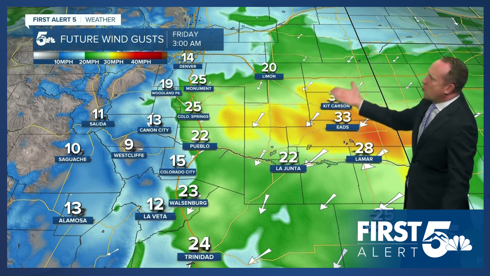
A strong cold front tonight will bring gusty north winds to Southern Colorado for a few hours. Skies will remain fairly cloudy tonight as well, with areas of light drizzle or showers possible into Friday morning.
Colorado Springs forecast: High: 87; Low: 51. Thursday will be hot and hazy as temperatures this afternoon soar into the upper 80s. A cold front tonight will bring the potential for overnight wind gusts to 30 mph, and areas of drizzle or light showers.
Pueblo forecast: High: 95; Low: 56. Thursday will be our hottest day of the week. Temperatures this afternoon will top out in the middle 90s. Tonight it will be gusty and cool, with overnight lows in the middle 50s.
Canon City forecast: High: 92; Low: 56. Hazy sunshine early will give way to a partly cloudy and hot afternoon, with our highs today soaring into the lower 90s. A strong cold front tonight will bring a big cool down to our forecast on Friday.
Woodland Park forecast: High: 78; Low: 41. The first week of September has brought us summer-like warmth and today will be the warmest day of the week as our high will peak this afternoon at 78 degrees. After tonight's cold front, our high tomorrow will be nearly 20 degrees cooler.
Tri-Lakes forecast: High: 80s; Low: 40s. We'll be feeling like summer on Thursday as today will be our hottest day of the week. Tonight's well advertised cold front will drop highs by more than 20 degrees on Friday.
Plains forecast: High: 90s; Low: 50s. Hazy skies and heat will give way to a windy night as a cold front comes sweeping across the Plains. Peak wind gusts of 40 mph will be possible into the overnight hours.
Walsenburg and Trinidad forecast: High: 80s/90s; Low: 40s/50s. Hot highs in the upper 80s and lower 90s will give way to a much cooler and cloudier day on Friday, with highs only in the 60s and 70s.
Mountains forecast: High: 60s/70s; Low: 30s/40s. Warm and hazy in the mountains on Thursday, with our best chances for rain today out towards the Continental Divide.
Extended outlook forecast:
Highs in the 80s and 90s on Thursday will be replaced with 60s and very low 70s on Friday, following the passage of tonight's cold front. Friday not only looks cooler, but mostly cloudy, with areas of drizzle and light showers possible throughout the day. Our low Friday night in the mid 40s in Colorado Springs will be the coolest temperature that we've seen since early June. Low in Teller County will cool down to near freezing in some areas.
Temperatures will recover into the 70s and low 80s this weekend, with a daily chance of showers and thunderstorms. Drier skies will return by early next week, with highs rising to above average territory.
____
Curious about the First Alert 5 Weather Storm Impact Scale? Check out our cheatsheet explainer.
Watch KOAA News5 on your time, anytime with our free streaming app available for your Roku, FireTV, AppleTV and Android TV. Just search KOAA News5, download and start watching.
