


Today’s Forecast:
A ridge of high pressure west of Colorado will push dry air through southern Colorado today, leading to a beautiful day. Although temperatures start cold - they'll rise quite quickly through this morning and you won't need the winter layers for long. It will be breezy today, particularly close to the mountains with a downslope northwesterly wind direction.
Highs ultimately top out today in the upper 50s to low 60s. If you have the chance to choose your outdoor plans days - today is certainly the pick compared to Friday and Saturday, as a strong cold front will bring significant changes to your sky over the next two days. It will also lead to a chilly Broncos game!
Colorado Springs forecast: High: 60; Low: 21.
Sunny and very mild. The average high is still 45 degrees today in Colorado Springs - so a solid 10-15 degrees above average depending on your elevation in town. Northwest winds at 10-15 mph, increasing to 15-20 mph and gusting to 25-30 mph from 10 AM - mid-afternoon mainly west of I-25 and toward the Palmer Divide. Get ready...a strong surge of cold air will sweep in tonight.
Pueblo forecast: High: 61; Low: 20.
Sunny and mild with northwest winds at 10-15 mph this morning, increasing to 15-20 mph in the afternoon and gusting to 30 mph. Overall, still a very nice day, but be prepared for the breeze...especially on the northwest side of town. Expect very low humidity this afternoon, so keep a water bottle around during any outdoor adventures.
Canon City forecast: High: 65; Low: 18.
Warm, sunny, and gusty today. Northwest winds at 10-15 mph this morning, increasing to 15-20 mph this afternoon and gusting to 30 mph at times. It will become less breezy by sunset as the pressure gradient weakens temporarily. Overall though, a spring-like day, and very dry.
Woodland Park forecast: High: 49; Low: 20.
Sunny and breezy with northwest winds at 10-20 mph gusting to 35 mph.
Tri-Lakes forecast: High: 50s; Low: 20s.
Sunny and quite mild with northwest winds at 10-15 mph gusting to 25 mph for most of the area. For the Mount Herman and Raspberry Mountain area, some slightly stronger gusts to 35 mph are possible from mid morning to early afternoon. This will mostly be on the back side of these mountains so if you're hiking the side facing I-25, you'll be sheltered from some of this wind. A nice outdoor day.
Plains forecast: High: 60s; Low: 20s.
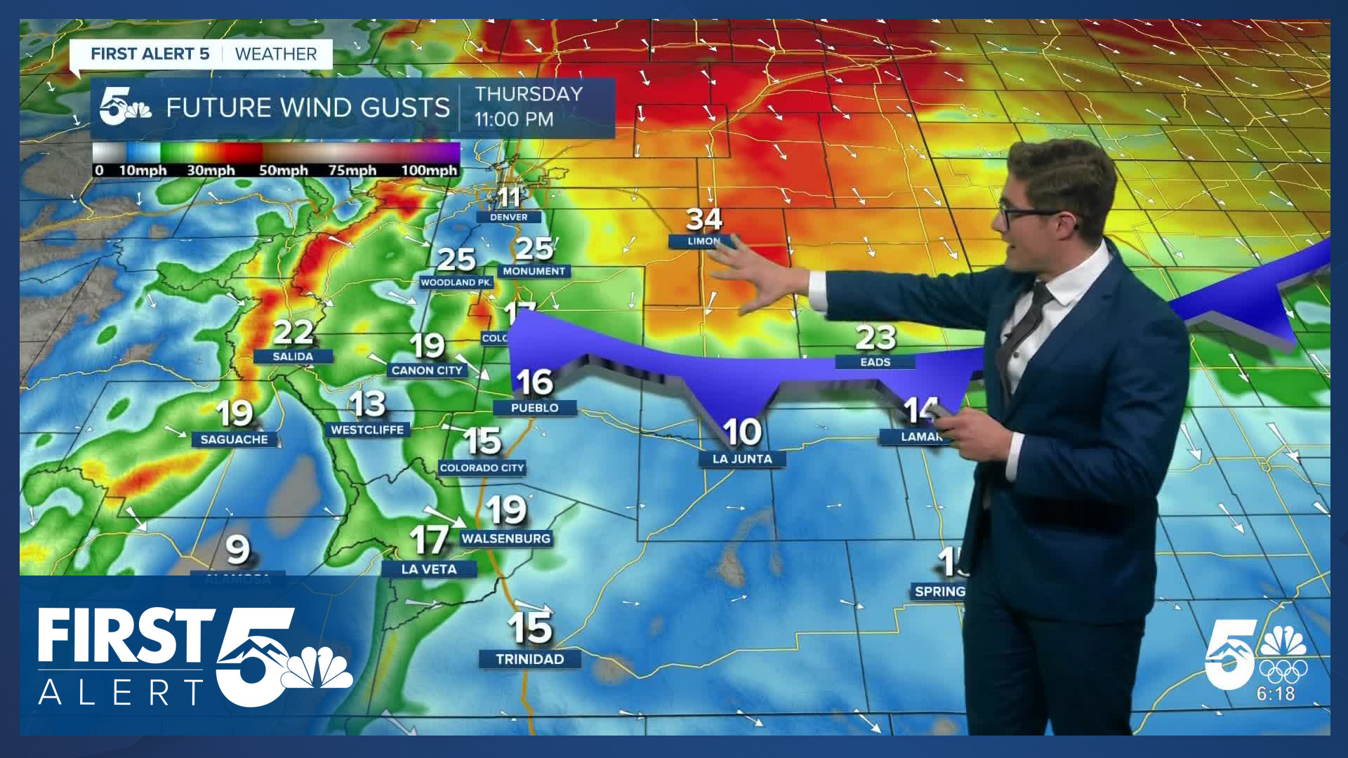
Sunny and modestly breezy with north northwest winds at 10-20 mph through mid afternoon then decreasing. Your main wind event comes tonight as a Canadian cold front arrives - it will push some 30-40 mph wind gusts through the easternmost counties overnight. The strongest winds will be in the northeastern part of the state but some of the wind will still mix down over the southeast plains.
Walsenburg and Trinidad forecast: High: 59/63; Low: 20s.
Downslope breezes in the gap flow zones west of and into Walsenburg today, not as potent in Trinidad, and clear and sunny in both cities. West northwest winds at 10-25 mph, gusting to 40 mph in Walsenburg but only to 30 mph in Trinidad.
Mountains forecast: High: 40s/50s; Low: 20s.
Sunny with northwest winds at 10-20 mph gusting to 35 mph in the southern mountains. Stronger wind in the northern mountains.
Extended outlook forecast:
The Canadian cold front will push in after sunset tonight, and it will be a bit of a shingle shaker - certainly a front you'll notice passing your home. You'll feel a quick cooldown of about 10 degrees in the hour following its passage. Canadian fronts tend to be dry - because they're pushing air from the center of the continent, and that is the case here. Therefore, while you might notice a few clouds with the front, that's not the main impact of this system.
Instead, the big impact is wind. The big contrast in temperatures - and density, if you want to be really specific - between the air behind this front, and the warmer air in front of it, plus significant upper level winds, lead to a gusty day on Friday. You'll wake up to temperatures in the low 20s across the plains, and highs warm to the upper 30s to low 40s. Skies will be partly to mostly cloudy, as wave clouds develop through the morning. Winds will gust from 20-35 mph in the Pikes Peak Region, but the strongest wind is by far going to be over the eastern and northeastern plains. High Wind Watches are in place Friday for the northeast plains of Colorado. It will not be as breezy Friday in Pueblo and areas south of highway 50.
A secondary push of cold air keeps the chill in place Saturday. Saturday morning lows will fall into the teens. Up to the north, even at 2:30 PM, the Broncos game kickoff will see temperatures in the middle 30s! Skies will be mostly sunny to partly cloudy in the Pikes Peak Region, with a couple weak snow sprinkles possible over the far eastern plains.
Temps rebound Sunday back to the 50s, before another Canadian front pushes temperatures back down into the 40s on MLK Jr. Day.
____
Curious about the First Alert 5 Weather Storm Impact Scale? Check out our cheatsheet explainer.
Watch KOAA News5 on your time, anytime with our free streaming app available for your Roku, FireTV, AppleTV and Android TV. Just search KOAA News5, download and start watching.
