



Today’s Forecast:
Pacific moisture will begin to increase across the state this afternoon, with rain spreading east/northeastward from the mountains to I-25 and the Plains. By late this evening and into the overnight hours, the first round of widespread rainfall will be possible. Rain is likely to continue into Tuesday morning. Snow levels will stay high overnight, at or above 12,000 feet.
Monday's temperatures will be as much as 5-10 degrees cooler than Sunday, topping out in the 70s and 80s on the Plains. Temperatures in the higher elevation areas will warm into the 60s.
Colorado Springs forecast: High: 71; Low: 54. A healthy cool down on Monday will take our high down from Sunday's high of 81 degrees to today's high in the lower 70s. Dry skies this morning will give way to spotty showers this afternoon and the potential for more widespread rain later tonight.
Pueblo forecast: High: 77; Low: 57. Monday's forecast will be cooler and more unsettled than what we saw back on Sunday afternoon. A few scattered showers this afternoon will give way to steadier, heavier rain later tonight.
Canon City forecast: High: 74; Low: 58. Quiet and mild conditions this morning will give way to scattered showers and thunderstorms this afternoon ahead of more widespread rain into the overnight hours.
Woodland Park forecast: High: 64; Low: 44. Dry skies this morning will give way to the potential for scattered showers and thunderstorms this afternoon, with a chance for for more widespread rain into the overnight hours.
Tri-Lakes forecast: High: 60s; Low: 40s/50s. Cooler and more mild conditions will follow yesterday's warm temperatures. Scattered showers and thunderstorms this afternoon will be followed by the potential for more widespread showers late tonight.
Plains forecast: High: 70s/80s; Low: 50s/60s. Today should be fairly dry on the Plains ahead of increasing chances for rain late tonight and into the day on Tuesday.
Walsenburg and Trinidad forecast: High: 60s/70s; Low: 40s/50s. Today will mark the start of an active stretch of weather for the next couple of days. Scattered showers during the day will give way to steadier and heavier rain tonight and Tuesday morning.
Mountains forecast: High: 50s/60s; Low: 30s/40s. Monday's forecast will bring a mix of rain showers, thunderstorms, and high elevation snow. Snow levels today will be around 12,000 feet. Heavier, steadier rain will fill into the southeaster mountains tonight and Tuesday.
Extended outlook forecast:
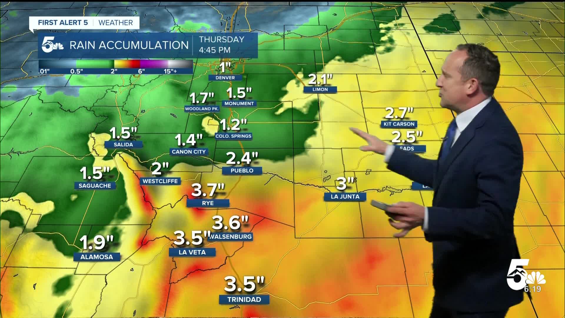
We should see a small break in precipitation during the day on Tuesday ahead of the potential for heavy rain by Tuesday night and Wednesday. The source of this moisture will be from a low pressure system that's currently over California, and Hurricane Polo. As these two systems merge, we will see an increased risk of flooding, mainly south of Highway 50.
In the Springs, we could see anywhere between 1-2" of precipitation this week, with locally higher totals possible. Highs will cool into the 60s on Tuesday, with upper 50s on Wednesday. A few lingering showers will be possible Thursday, with a cool high in the lower 60s.
Sunshine returns Friday as highs rebound into the upper 60s. Dry skies follow this weekend, with lower to middle 70s in Colorado Springs.
____
Curious about the First Alert 5 Weather Storm Impact Scale? Check out our cheatsheet explainer.
Watch KOAA News5 on your time, anytime with our free streaming app available for your Roku, FireTV, AppleTV and Android TV. Just search KOAA News5, download and start watching.
