



Today’s Forecast:
After a hot weekend, our latest heat spell will peak on Monday, with 90s and 100s on tap for the Plains, and mid to upper 80s for some of our cooler mountain locations.
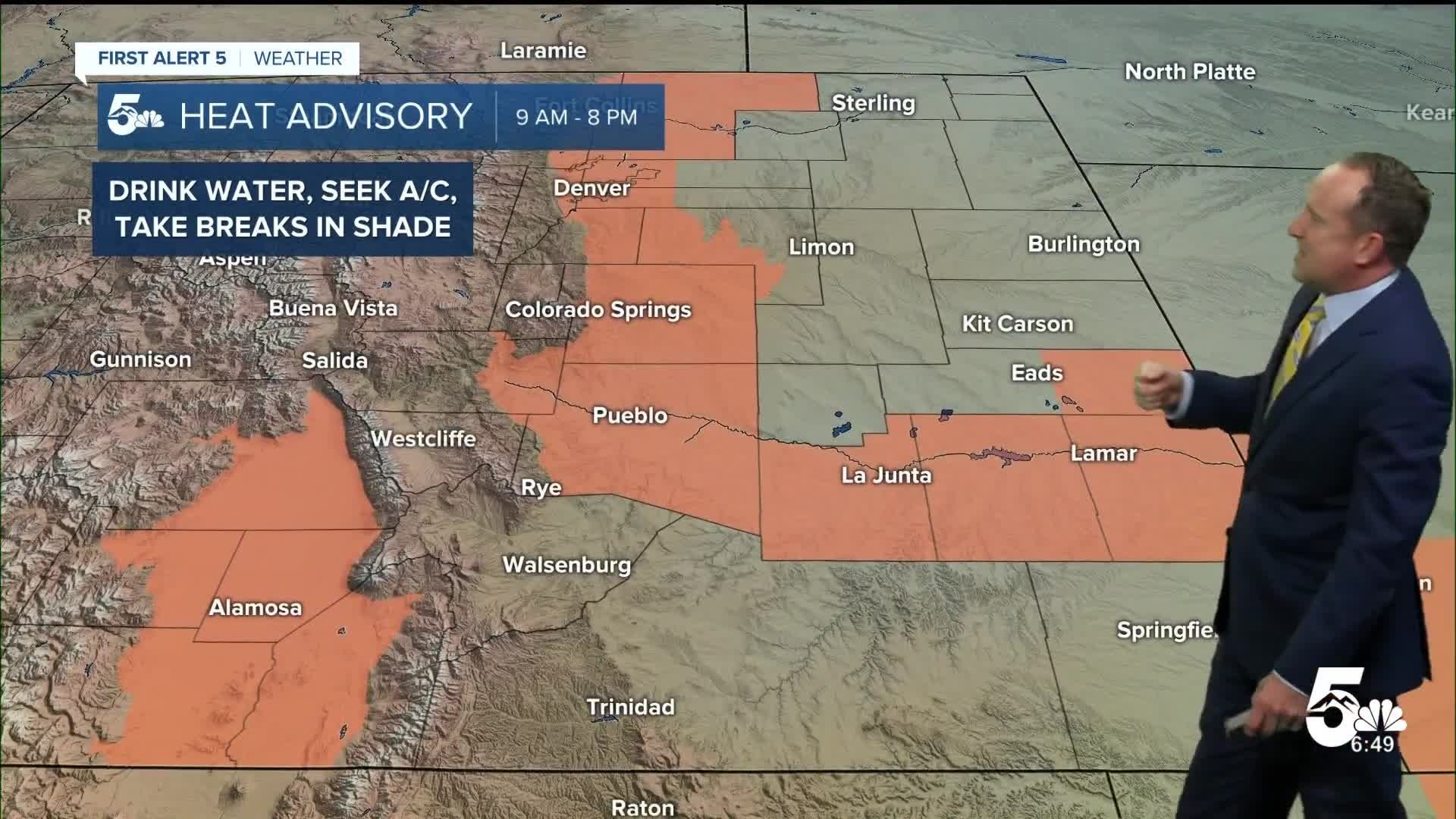
A HEAT ADVISORY has been issued for the I-25 corridor, from the far northern part of the state all the way down to Pueblo County. Also included in the advisory will be the middle and lower Arkansas River Valley, and the San Luis Valley.

While most areas will stay dry today, high based showers will form in the mountains by around the lunch hour, before moving east into the Plains. Due to dry air at the surface, these storms are more likely to produce gusty winds and dry lightning than any significant rainfall.
A potent cold front will drop in from the north after sunset tonight, with 30-50 mph wind gusts expected into overnight hours. Winds should taper off early Tuesday morning.
Colorado Springs forecast: High: 98; Low: 60. Today's forecast will approach the daily record high of 99°F, last set in 1954. Try to find a way to keep cool this afternoon by staying in the air conditioning, or seeking shade if you have to be outside.
Pueblo forecast: High: 105; Low: 65. Today's forecast high of 103°F is expected to blast past the current record of 105°, last set in 1902. This is expected to be our 11th day in the triple digits this summer for Pueblo. We average 12 in a year.
Canon City forecast: High: 102; Low: 65. Blazing heat will be the big story today in eastern Fremont County, with highs today expected to warm above 100 degrees. Widely scattered showers will be possible this afternoon, with more wind than rain due to dry air at the surface.
Woodland Park forecast: High: 88; Low: 48. Parts of Teller County are likely to hit the 90 degree mark this afternoon as high pressure peaks over the area. Recycled moisture and daytime heating will combine to produce widely scattered showers this afternoon. Wind and dry lightning will be the main threats today for areas that see a storm.
Tri-Lakes forecast: High: 90s; Low: 50s. It will be a sizzling hot start to the week as temperatures soar into the lower to middle 90s today in northern El Paso County.
Plains forecast: High: 100s; Low: 60s. Many of our counties on the eastern Plains will be under a Heat Advisory today, in effect from 9 am to 8 pm. Some of the hottest locations could top 105°, with a few isolated storms possible this evening, especially out towards the eastern counties.
Walsenburg and Trinidad forecast: High: 90s/100s; Low: 60s. Find a way to keep cool this afternoon because it will be a hot and dry start to the week. Highs will warm into the 90s and 100s this afternoon before cooling down to the 80s on Tuesday.
Mountains forecast: High: 70s/80s; Low: 40s/50s. It will be a very warm start to the week in the high country, with highs today warming mostly into the 80s. Moisture will increase early this week, with a few isolated showers and thunderstorms possible this afternoon.
Extended outlook forecast:
Tuesday will be our coolest day of the week, with highs down around 15-20 degrees region-wide. Temperatures in Colorado Springs will warm into the lower 80s, with highs in Woodland Park and Monument only warming into the 70s.
There could also be a few showers and thunderstorms on Tuesday, favoring the mountain zones and I-25 corridor near the Pikes Peak Region.
Highs in Colorado Springs will return to near average territory in the middle 80s, with only a small chance of a shower or thunderstorm Wednesday afternoon. Highs could hit 90 degrees by Thursday, with further warming this weekend, and the potential for more record-breaking heat across Southern Colorado.
____
Curious about the First Alert 5 Weather Storm Impact Scale? Check out our cheatsheet explainer.
Watch KOAA News5 on your time, anytime with our free streaming app available for your Roku, FireTV, AppleTV and Android TV. Just search KOAA News5, download and start watching.
