

Tonight's Forecast:
It will be a breezy night, especially in the mountains and along I-25. Wind gusts will be out of the W at 20-30 mph. This will keep these zones warmer than normal and above freezing. The San Luis Valley and eastern plains will be cold, dropping near or below freezing.
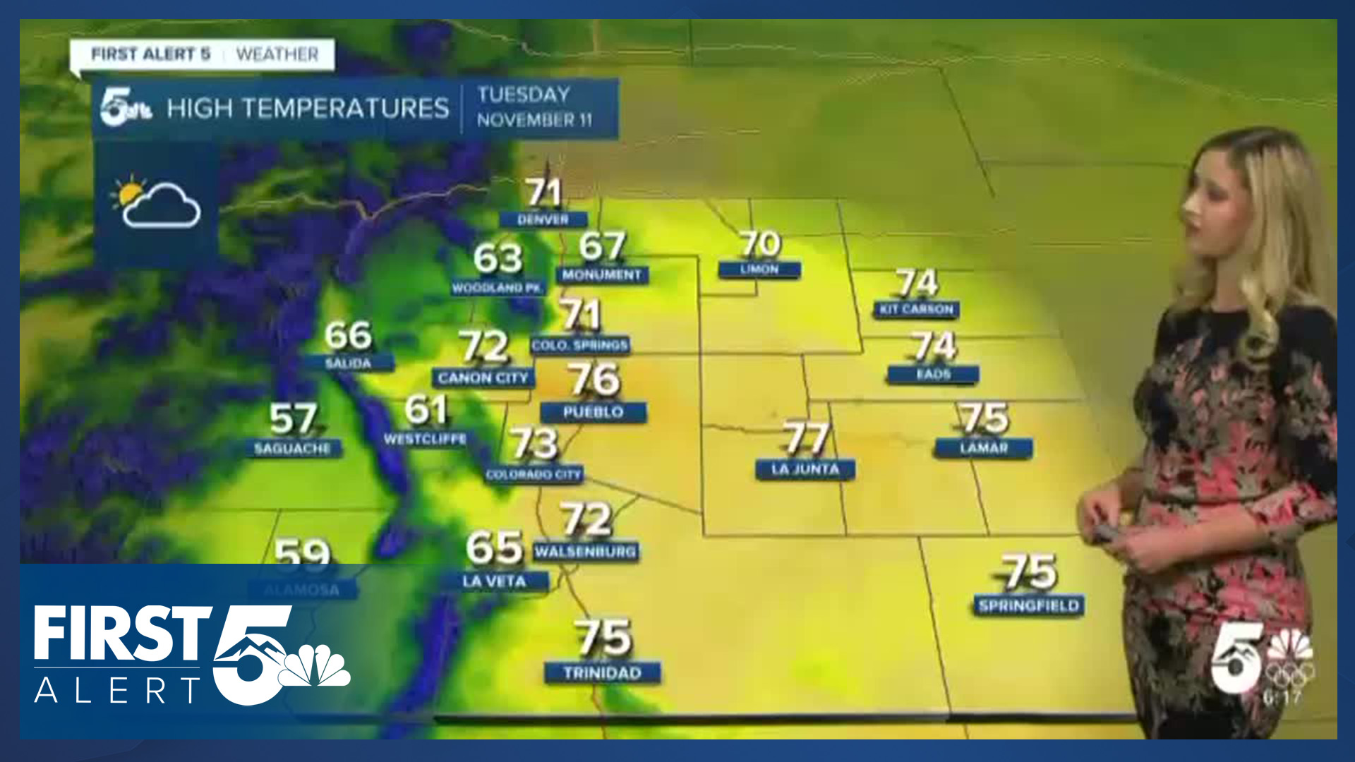
Colorado Springs forecast: Low: 40; High: 71;
It will be a very warm Veterans Day in Colorado Springs. The forecast high of 71 will be close to the daily record high of 73, set in 1999. Winds will be breezy, especially in the morning, out of the WNW at 5-10 mph, gusting to 20 mph. There will be high clouds in place all day.
Pueblo forecast: Low: 33; High: 76;
A very warm Veterans Day is in store. Wind will be out of the W at 10 mph gusting to 20 mph. The sky will be partly cloudy.
Canon City forecast: Low: 40; High: 72;
Mostly cloudy with high clouds on Tuesday, but temperatures will be mild. Wind will be out of the W at 10 mph gusting to 25 mph.
Woodland Park forecast: Low: 37; High: 63;
It will be breezy and mild on Tuesday with high clouds. Wind will be out of the W at 10-15 mph, gusting to 30 mph.
Tri-Lakes forecast: Low: 39; High: 67;
It will be mostly cloudy with high clouds on Tuesday. Temperatures will be mild with a breezy W wind at 5-15 mph gusting to 25 mph.
Plains forecast: Low: 30s; High: 70s;
It will be partly cloudy with high clouds on Tuesday. Temperatures will be warm in the low to mid-70s. Winds will be variable, at 5-15 mph gusting 15-25 mph.
Walsenburg and Trinidad forecast: Low: 40/42; High: 72/75;
It will be partly cloudy on Tuesday with warm temperatures. Winds will be breezy out of the W at 5-15 mph, gusting 25-30 mph.
Mountains forecast: Low: teens-30s; High: 50s-60s;
The mountain valleys will be breezy on Tuesday, especially in the morning, with W wind at 10-15 mph gusting 20-30 mph. Temperatures will be mild in the afternoon.
Extended outlook forecast:
From Wednesday through Friday, temperatures will remain about 10 degrees above average in the 60s and 70s. It will be dry with high clouds for the rest of the week.
Winds will increase on Friday ahead of our next cold front. The cold front and incoming storm system will drop temperatures this weekend and bring moisture to the state. The highest chance for precipitation between Friday and Sunday will be snow in the mountains. There is potential for rain or a wintry mix east of the mountains and for I-25 on Saturday or Sunday. There is high uncertainty in the storm track and where showers will fall. But this cool-down will last a while, through all of next week at least.
____
Curious about the First Alert 5 Weather Storm Impact Scale? Check out our cheatsheet explainer.
Watch KOAA News5 on your time, anytime with our free streaming app available for your Roku, FireTV, AppleTV and Android TV. Just search KOAA News5, download and start watching.
