

Tonight's Forecast:
After a day of record heat, Tuesday night will not be cooling down very much. Overnight lows will be about 20 degrees above average. There will be a breeze in the mountains overnight, with generally calm conditions in the plains.
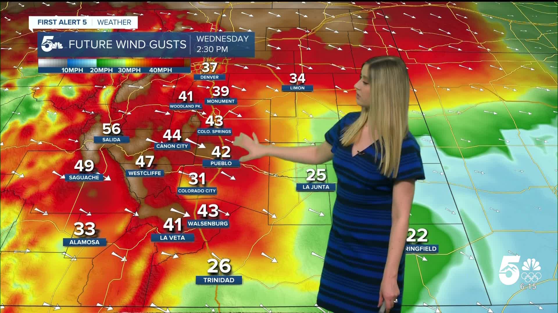
On Wednesday, more heat and wind are expected. A RED FLAG WARNING goes into effect at 11 am and expires at 5 pm.

Colorado Springs forecast: Low: 41; High: 72;
RED FLAG WARNING from 11 am until 5 pm. Wind will be out of the WNW at 15-25 mph, gusting to 45 mph. The daily record high stands at 71 from 1986.
Pueblo forecast: Low: 40; High: 77;
RED FLAG WARNING from 11 am until 5 pm. Wind will be out of the WNW at 15-25 mph, gusting to 45 mph. The daily record high stands at 80 from 1986.
Canon City forecast: Low: 40; High: 73;
It will be very windy and warm on Wednesday. Wind will be out of the WNW at 20-30 mph, gusting to 50 mph.
Woodland Park forecast: Low: 36; High: 58;
Wednesday will be mild for late February and very windy. Wind will be from the W at 20-30 mph gusting to 50 mph.
Tri-Lakes forecast: Low: 43; High: 65;
RED FLAG WARNING from 11 am until 5 pm. It will be warm and windy with WNW wind to 15-25 mph gusting to 40 mph.
Plains forecast: Low: 30s-40s; High: 70s;
RED FLAG WARNING from 11 am until 5 pm for Otero and eastern Las Animas Counties. It will be gusty and warm on Wednesday. Wind will be out of the WNW at 10-20 mph, gusting 20-35 mph.
Walsenburg and Trinidad forecast: Low:49/43; High: 72/75;
RED FLAG WARNING from 11 am until 5 pm. It will be very warm again and windy. Wind will be out of the WNW at 15-30 mph, gusting to 45 mph in Walsenburg and 35 mph in Trinidad.
Mountains forecast: Low: teens-30s; High: 50s-60s;
A windy and mild Wednesday is in store for the mountain valleys. Wind will be out of the WNW at 20-30 mph, gusting 45-55 mph.
Extended outlook forecast:
Thursday will be about 10 degrees cooler with a dry cold front. It will remain a breezy day, with gusts up to 30 mph in the plains and to 40 mph in the mountains. With dry and breezy wind, fire danger will be elevated, prompting a fire weather watch.

____
Curious about the First Alert 5 Weather Storm Impact Scale? Check out our cheatsheet explainer.
Watch KOAA News5 on your time, anytime with our free streaming app available for your Roku, FireTV, AppleTV and Android TV. Just search KOAA News5, download and start watching.
