


Tonight's Forecast:
A gorgeous evening is expected across Southern Colorado under clear skies, light winds and seasonably mild temperatures. Overnight lows won't be as cold as last night, with 40s and 50s expected by Sunday morning for areas outside of the mountains.
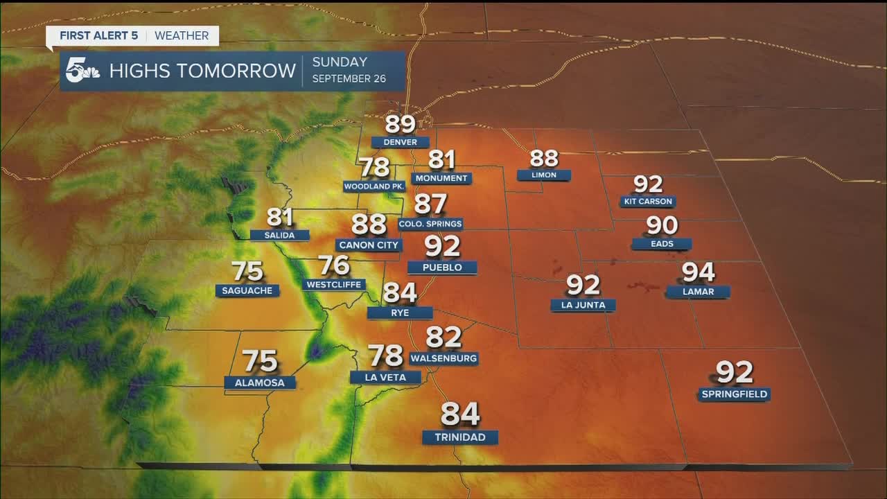
COLORADO SPRINGS: Low: 52; High: 87. Even hotter on Sunday, with increasing clouds during the afternoon and evening hours, but no real potential for any rainfall.
PUEBLO: Low: 50; High: 92. A cool start to our Sunday will give way to a hot afternoon for the final day of the Pueblo Chile & Frijoles Festival.
CANON CITY: Low: 57; High: 88. Sunday's forecast will be a toasty one, with increasing clouds and upper 80s for daytime highs.
WOODLAND PARK: Low: 46; High: 78. Warm and breezy on Sunday, with mostly sunny to partly cloudy skies expected during the afternoon and evening hours.
TRI-LAKES: Low: 40s/50s; High: 70s/80s. Warmer than average highs on Sunday, with sunshine early giving way to increasing clouds during the afternoon and evening hours.
PLAINS: Low: 40s/50s; High: 80s/90s. It'll be a hot end to the weekend across the Plains, especially for areas along the Arkansas River Valley, where daytime highs will soar into the lower to middle 90s.
WALSENBURG/TRINIDAD: Low: 40s/50s; High: 70s/80s. Far southern parts of the state may see more effects than the rest of us from a storm over Arizona. Look for increasing clouds during the afternoon, and even the potential for an isolated shower or thunderstorm.
MOUNTAINS: Low: 30s/40s; High: 60s/70s. Increasing moisture over the southern half of the state could lead to a few isolated showers or thunderstorms across the San Juan Mountains and southern Sangres. Outside of these areas, rain is not expected on Sunday.
Extended Outlook:
No big changes on Monday, even as high pressure begins to shift east of our region. Highs will really start to cool by the middle of next week as a larger disturbance from the Pacific Northwest moves into Colorado. This will bring a mix of 50s, 60s and 70s to the forecast beginning on Wednesday, along with near daily rain chances for the end of the work week and the start of the following weekend.
KOAA News5 on your time, streaming on your Roku, FireTV, AppleTV and AndroidTV.
News5 App | First Alert 5 Weather App | Youtube | Facebook | Instagram | Twitter