



Today’s Forecast:
A potent cold front is dropping south across the state very quickly this morning. Behind the front, there will be a period of gusty north winds for areas along and east of the eastern mountain slopes. Gusts into the Plains will range between 30-40 mph for a few hours, before weakening in most areas after 9-10 am.
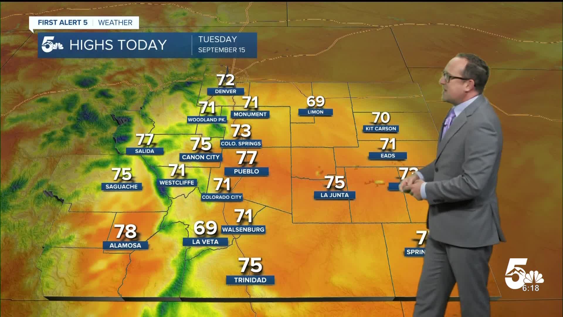
Behind the front, a cooler and more stable atmosphere will settle into Southern Colorado this afternoon. Highs will be as much as 10-20°F cooler, only topping out in the 60s and 70s. Overnight lows tonight will be on the cool and crisp side as well, dropping down to the 40s and 50s.
Colorado Springs forecast: High: 73; Low: 51. A blustery and cool morning will give way to a taste of fall this afternoon. Our high of 73 degrees will be our coolest day since the 14th of June.
Pueblo forecast: High: 77; Low: 53. It's been more than three months since we've seen air this cool in the Pueblo area, so take advantage of the cool, and grab lunch outside this afternoon.
Canon City forecast: High: 75; Low: 54. Tuesday's forecast will be a cool and refreshing change as highs will only warm into the mid 70s. Storm activity will favor the high country today, with just a slight chance here of an afternoon or evening thunderstorm.
Woodland Park forecast: High: 71; Low: 48. Tuesday's temperatures will be mild and comfortable, with isolated to spotty thunderstorms possible towards the afternoon and early evening hours.
Tri-Lakes forecast: High: 60s/70s; Low: 40s/50s. The stronger wind gusts that have been blowing around this morning will give way to weakening wind and fall-like temperatures this afternoon as highs top out in the
Plains forecast: High: 70s; Low: 50s. Wind gusts to 45 mph will continue up until the lunch hour before weakening and turning to the east/southeast this afternoon. Skies are expected to remain dry on the Plains today, with highs today comfortably into the 70s.
Walsenburg and Trinidad forecast: High: 60s/70s; Low: 40s/50s. A welcomed change to our forecast will arrive today, with highs this afternoon only warming into the 60s and 70s.
Mountains forecast: High: 60s; Low: 40s. Cool weather on Tuesday for the mountains, with scattered thunderstorms expected this afternoon.
Extended outlook forecast:
Wednesday's highs will warm into the upper 70s and lower 80s in Colorado Springs, with highs remaining near 80 degrees for the rest of the week.
Moisture will increase starting on Wednesday. This will bring the potential for heavy rain and flooding to the mountains and our recent burn scars. Showers will also become more numerous in the Pikes Peak Region, with scattered thunderstorms likely each day from Wednesday to Friday. Storms will remain possible this weekend, with afternoon highs cooling back down to the 70s.
____
Curious about the First Alert 5 Weather Storm Impact Scale? Check out our cheatsheet explainer.
Watch KOAA News5 on your time, anytime with our free streaming app available for your Roku, FireTV, AppleTV and Android TV. Just search KOAA News5, download and start watching.
