

Tonight's Forecast:
The Aurora Borealis is visible tonight in Colorado! Go outside, away from city lights, and you should be able to see them on the northern horizon.
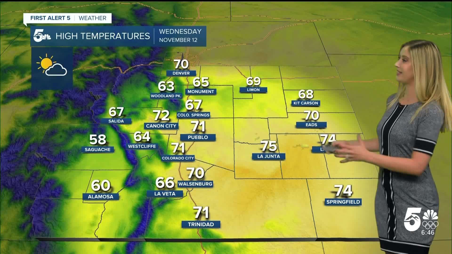
Weather conditions tonight will be mostly clear with a few high clouds. Temperatures will be near average or a few degrees above average.
Colorado Springs forecast: Low: 35; High: 67;
It will be partly cloudy on Wednesday. Temperatures will still be about 10 degrees above average. Wind will be out of the S at 5-10 mph.
Pueblo forecast: Low: 33; High: 71;
Wednesday will be partly cloudy and warm. Wind will be out of the SSE at 5-10 mph, gusting to 15 mph.
Canon City forecast: Low: 40; High: 72;
It will be partly cloudy on Wednesday with W wind at 5-10 mph gusting to 15 mph.
Woodland Park forecast: Low: 32; High: 63;
It will be partly cloudy with WSW wind at 5-10 mph gusting to 15 mph.
Tri-Lakes forecast: Low: 34; High: 65;
It will be partly cloudy on Wednesday with S wind at 5-10 mph gusting to 15 mph.
Plains forecast: Low: 30s; High: 60s-70s;
It will be partly cloudy and warm on Wednesday. Wind will be light, generally out of the S at 5-10 mph.
Walsenburg and Trinidad forecast: Low: 37/39; High: 70/71;
It will be partly cloudy on Wednesday with mild temperatures. Winds will be light, out of the SSW at 5-10 mph.
Mountains forecast: Low: 20s-30s; High: 50s-60s;
It will be partly cloudy to mostly sunny on Wednesday with cool but comfortable temperatures in the mountain valleys. Wind will be light, less than 15 mph.
Extended outlook forecast:
Temperatures remain well above average through the end of the week, in the 60s and 70s.
The storm we are watching for the weekend has slowed down a bit. Saturday is trending warmer in the 60s still. The cooler weather looks to arrive on Sunday when we drop to the 50s. Sunday also brings a chance of rain in Colorado Springs, with a slushy wintry mix possible in the evening. If a transition to snow were to happen Sunday night, accumulations would likely be light and only in the grass. Snow is expected in the mountains on Sunday, so prepare for winter driving conditions, especially in the high elevations.
____
Curious about the First Alert 5 Weather Storm Impact Scale? Check out our cheatsheet explainer.
Watch KOAA News5 on your time, anytime with our free streaming app available for your Roku, FireTV, AppleTV and Android TV. Just search KOAA News5, download and start watching.
