

Today’s Forecast:
After a chilly weekend, temperatures will be in recovery mode today, jumping up as much as 10-20 degrees across Southern Colorado. Highs will rebound into the 50s and 60s, with afternoon winds on the Plains from the S/SE, sustained at 10-15 mph.
As high pressure breaks down this evening, this will allow for the downslope flow to strengthen, setting the stage for a breezier Tuesday. The developing downslope wind will also lead to a more mild night across Southern Colorado.
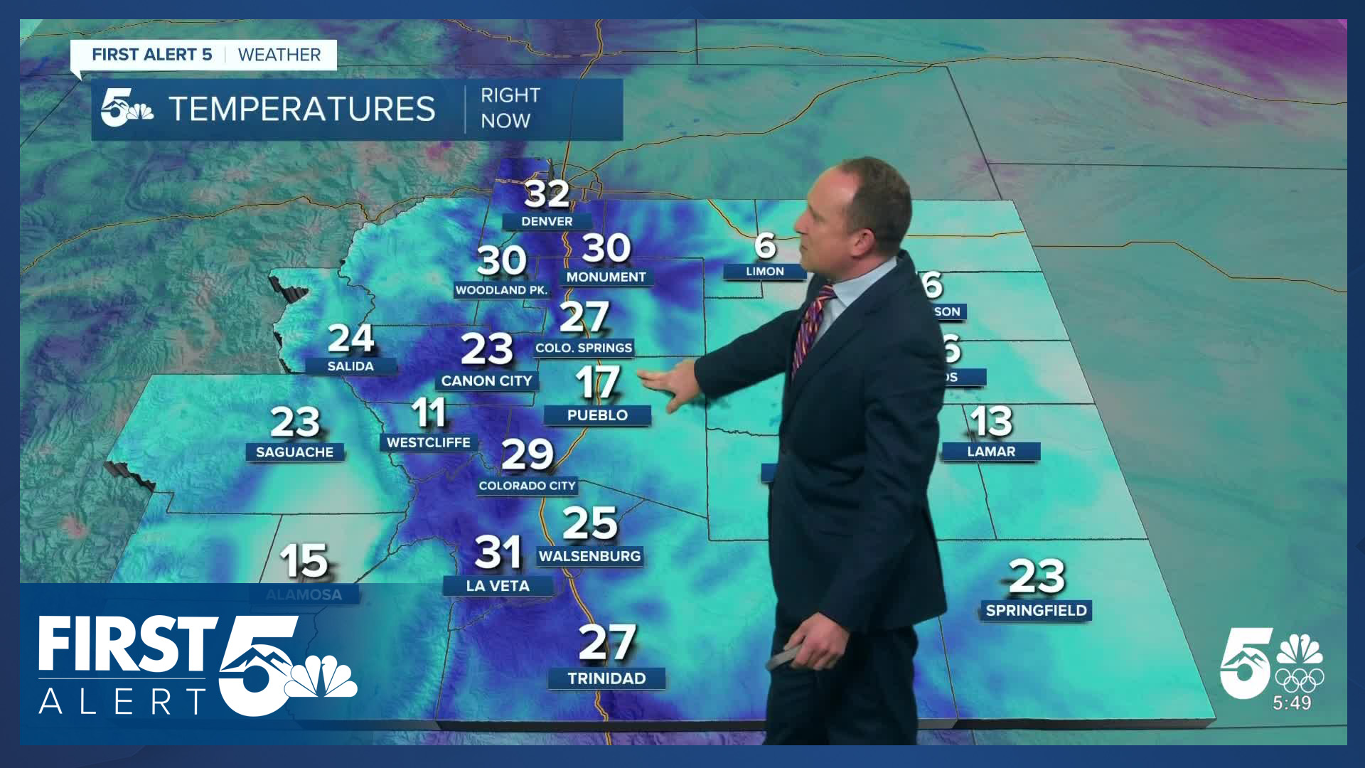
Colorado Springs forecast: High: 61; Low: 34. After only warming into the 40s this past weekend, today's forecast will be bright and mild, with light S/SE winds during the day.
Pueblo forecast: High: 64; Low: 30. Our work week will begin bright and beautiful, with light breezes and mostly sunny to partly cloudy skies. Afternoon highs on Monday will be around 10-12 degrees above average.
Canon City forecast: High: 65; Low: 37. Mid and upper level clouds will thin out this morning, leaving us mostly sunny and mild as we make our way into the afternoon hours. Highs today will warm into the middle 60s, with lower 70s by Tuesday.
Woodland Park forecast: High: 54; Low: 31. Warmer temperatures are set to return this week after a chilly weekend in Teller County. Highs today will warm into the middle 50s, with upper 50s by Tuesday afternoon.
Tri-Lakes forecast: High: 50s/60s; Low: 30s. Even though it is a Monday, today will be my pick day of the week. Highs will be mild, with dry skies and light breezes across northern El Paso County.
Plains forecast: High: 50s/60s; Low: 20s/30s. It's going to be a beautiful start to the week on the Highs Plains, with today's forecast featuring above average temperatures, mostly sunny skies, and light SE winds.
Walsenburg and Trinidad forecast: High: 60s; Low: 30s. Mild highs and light W/SW winds will give way to increasing wind this evening. This trend will continue into the day on Tuesday, increasing the threat for high fire danger.
Mountains forecast: High: 40s; Low: 20s. Much like the eastern Plains, the mountains will also see nice weather on this final Monday of February. As storm energy drops in from the north this evening, we will see increasing wind into the overnight hours, with gusts tonight to 40 mph.
Extended outlook forecast:
High pressure will begin to break down on Tuesday, allowing for stronger wind to develop across the Pikes Peak Region and Southern Colorado. Fire Weather Watches have been issued for El Paso County and much of the I-25 corridor on Tuesday. Gusts around 30-40 mph will be possible, with relative humidity down as low as 10%.
The other story on Tuesday will be the warmth! Our forecast high in Colorado Springs of 71 degrees would tie the current record of 71, last set in 1986.
Wednesday has the potential to be even windier than Tuesday, but with higher humidity, fire danger threats may be slightly lower on the Plains. There's also the potential for heavy snow and wind in the mountains on Wednesday, with a quick shot of precip also possible for the Pikes Peak Region. For now, this looks to favor Teller County and the Palmer Divide.
Fire danger may ramp back up Thursday to Friday as highs remain above average during the remainder of the week.
____
Curious about the First Alert 5 Weather Storm Impact Scale? Check out our cheatsheet explainer.
Watch KOAA News5 on your time, anytime with our free streaming app available for your Roku, FireTV, AppleTV and Android TV. Just search KOAA News5, download and start watching.
