


Tonight's Forecast:
Clouds and snow will begin to spread into the mountains late tonight, but for the Plains, we won't see any of that moisture until at least late Wednesday night. Instead, developing downslope breezes will keep overnight lows east of the mountains on the mild side, with a mix of 30s and 40s.
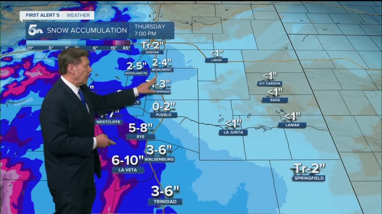
Colorado Springs forecast: Low: 37; High: 69; The warm-up continues on Wednesday as highs in the Pikes Peak Region look to top out near 70 degrees. By midnight, rain showers will begin to develop, with a changeover to snow expected by Thursday morning.
Pueblo forecast: Low: 36; High: 76; Nice and warm on Wednesday, and with middle 70s in the forecast, this looks to be our warmest day of the year so far. After midnight, moisture will start to increase, with a changeover from rain to snow expected by Thursday morning.
Canon City forecast: Low: 39; High: 72; Wednesday's forecast will be a classic case of the warm before the storm. But all good things must come to an end, and by late Wednesday night, our next storm will be moving in with a rain/snow mix for the overnight hours.
Woodland Park forecast: Low: 31; High: 60; A nice pre-season sample of spring for Teller County on Wednesday will give way to a major case of weather whiplash on Thursday, with around 30 degrees of cooling and snow.
Tri-Lakes forecast: Low: 30s; High: 60s; Mother Nature will deliver some gorgeous weather to the Tri-Lakes region on Wednesday, with dry skies during the day giving way to late night rain and snow showers.
Plains forecast: Low: 30s/40s; High: 70s; Warm and breezy on Wednesday, with middle to upper 70s for our daytime highs. Increasing clouds after midnight will give way to rain/snow showers by Thursday morning.
Walsenburg and Trinidad forecast: Low: 30s/40s; High: 60s/70s; Warm and gusty on Wednesday, with spotty high fire danger possible in some areas. Peak afternoon wind gusts of 25-35 mph will be possible near eastern mountain slopes.
Mountains forecast: Low: 20s/30s; High: 40s/50s; Dry skies early on Wednesday will give way to snow by Wednesday afternoon and evening. Periods of heavy snow and strong winds will follow from late Wednesday night into the day on Thursday, with 6-16" of accumulation for the Wets, Sangres and Wet Mountain Valley.
Extended outlook forecast:
The latest details regarding our mid-week winter storm still show a significant snow maker for the mountains, with impacts expected to be much less for the I-25 corridor and eastern Plains. As moisture increases after midnight Wednesday, a slow changeover from rain to snow will occur. By Thursday morning, we're looking at a heavy, wet snow for parts of the Plains. The biggest impacts will be west of I-25 and south of Highway 50.
Heavy snow & high impacts for the mountains on Wednesday & Thursday.⁰⁰For the Plains...warm air ahead of the storm will mean a slow transition from rain to snow and melting once the snow begins. Snow totals we think will be highest west of I-25 and south of Hwy 50. #cowx pic.twitter.com/HRgxLQau79
— Alan Rose (@AlanRoseWX) March 14, 2023
On top of the snow, Thursday will be windy and around 30-40 degrees colder. We'll dry out for St. Patrick's Day, but the cold will linger.
____
Curious about the First Alert 5 Weather Storm Impact Scale? Check out our cheatsheet explainer.
Watch KOAA News5 on your time, anytime with our free streaming app available for your Roku, FireTV, AppleTV and Android TV. Just search KOAA News5, download and start watching.
