

Today’s Forecast:
Your Friday begins mostly sunny, with a broken-record pattern of downslope breezes contributing to the mild start. An elongated area of low pressure is located between Southern California and Nevada. It will pivot toward the Four Corners region through the day as a weak surface low moves through Arizona and New Mexico. As it does so, snow will return to the high country with several more inches of snow in the high mountain zones. Clouds increase in coverage this afternoon with mild highs once again on the Plains.
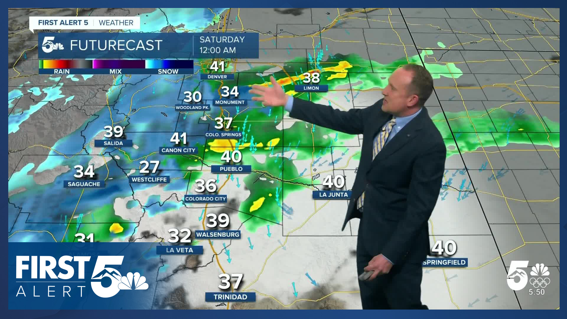
As the surface low pivots through eastern New Mexico, upslope flow across the Pikes Peak Region leads to a chance of rain showers arriving, which will be moderate to briefly heavy. A wintry mix is possible overnight with the snow level staying generally above 6,000-6,500 feet. Monument Hill could get a couple of inches of snow, as could Woodland Park, into the overnight hours. Higher amounts will be possible in the southern Sangres.
Colorado Springs forecast: High: 54; Low: 32. Dry skies and sunshine early will give way to increasing clouds throughout the day as low pressure tracks into Arizona. This storm will pump moisture into the state, with rain developing this evening. As for snow, snow levels will be high enough that most of Colorado Springs shouldn't see any impacts or accumulations, with a light dusting possible above 6,000 to 6,500 feet.
Pueblo forecast: High: 59; Low: 33. Dry skies this morning and this afternoon will give way to increasing chances for rain this evening. Due to the warm nature of today's storm and high freezing level, snow is not expected in Pueblo.
Canon City forecast: High: 57; Low: 35. Skies will turn mostly cloudy throughout the day, with rain developing by late this afternoon and evening. With snow levels expected to remain above 6,500 feet, snow is not likely with tonight's storm.
Woodland Park forecast: High: 48; Low: 26. Unsettled skies on Friday will replace the dry weather that we've seen this past week. Snow showers will pick up this afternoon and evening. The snow level will start out at around 8,000 feet before lowering to 6.000 to 6,500 feet. Snow totals of a trace to 2" for Teller County.
Tri-Lakes forecast: High: 50s; Low: 20s/30s. Friday will start out very differently than it ends. Sunshine early will give way to increasing clouds this afternoon and rain and snow showers this evening. As snow levels drop to below 6,500 feet later tonight, snow totals in some areas could top 1-2" by Saturday morning.
Plains forecast: High: 50s/60s; Low: 30s. Dry skies this morning will give way to rainy night on the eastern Plains. Along with the rain, it's possible that we could see a few thunderstorms rumble across the Plains later tonight, with showers decreasing Saturday morning.
Walsenburg and Trinidad forecast: High: 50s/60s; Low: 30s. A warm, incoming storm will bring mainly rain to the southern I-25 corridor from late Friday afternoon into Saturday morning. While a chance for snow mixed with rain may occur down to 6,000 feet, accumulations are not expected from this storm.
Mountains forecast: High: 30s/40s; Low: 20s. Some much needed moisture will bring snow to the southeastern mountains starting this afternoon. Snow levels will start out at around 8,000 before dropping under 7,000 feet. As much as 3-6" of snow will fall from the storm over the southern Sangres. 1-3" of snow is possible in the Wet Mountains.
Extended outlook forecast:
If you're heading up to Cripple Creek for their famous Ice Festival this weekend - the weather certainly won't feel icy, even up at 9,500 feet of elevation. Highs will be in the lower 40s Saturday, and then 50s Sunday and Monday. Monday will also be breezy - a prelude to more significant wind heading to Southern Colorado by mid-week.
Precipitation may linger through Saturday morning, with clearing skies by the afternoon and fairly similar highs in the mid 50s to lower 60s. Sunday remains mainly sunny and a bit warmer as upper-level high pressure moves back into the state.
Fire danger begins to increase Monday. Ridging begins to move east with a strong upper level low to the west. This increases the strength of the jet stream - and that stronger jet stream begins to nudge into Colorado. It will be breezy with southwesterly winds, and dry. Highs will be in the middle 60s to lower 70s on the Plains.
Tuesday and Wednesday are the most concerning days in this set up. Both days will be windy and fire danger will be high with low humidity. Both days feature a potent jet streak in the upper atmosphere over Colorado - this is a region of faster winds within the overall jet stream. This pattern can yield significant downslope winds. In this setup, lee troughing - low pressure to the east of the mountains - is also likely, which can also help with transferring the wind down from higher elevations. The question at the moment is less "will fire danger be high", but rather, "how high", and whether the winds will also result in damage potential on their own.
Finally - while Southern Colorado looks dry, there is plentiful moisture to the west with the incoming upper-level system, meaning moderate to heavy wind-driven snow is possible in the mountains Tuesday through the middle of next week. Winter travel conditions are expected there.
____
Curious about the First Alert 5 Weather Storm Impact Scale? Check out our cheatsheet explainer.
Watch KOAA News5 on your time, anytime with our free streaming app available for your Roku, FireTV, AppleTV and Android TV. Just search KOAA News5, download and start watching.
