

Today’s Forecast:
Happy Star Wars Day, and May the Fourth Be With You! After a couple of drier days and a weekend warm-up, changes are on the way for Southern Colorado this week. Today's highs will be similar to maybe a degree or two warmer than what we saw on Sunday. Temperatures will climb into the 70s and lower 80s on the Plains, with 50s and 60s for Teller County and our mountain valleys.
As moisture increases this afternoon, spotty showers and thunderstorms will be possible. Chances for rain today will be highest for areas north of Highway 50. Snow levels on Monday will be at or above 10,000 feet.
Colorado Springs forecast: High: 72; Low: 40. After drying out this past weekend, we'll see the potential for a few isolated showers and thunderstorms this afternoon and evening. Severe weather is not expected on Monday.
Pueblo forecast: High: 80; Low: 43. We'll be flirting with 80 degrees this afternoon in Pueblo, with mostly sunny skies this morning turning mostly cloudy by the afternoon. Rain chances will be fairly low today in Pueblo, but a shower will still be possible this afternoon or evening.
Canon City forecast: High: 77; Low: 44. The work week will begin on a warm, spring-like note, with afternoons high today in the upper 70s more than 5 degrees above average. An isolated shower or two will be possible this afternoon, but it won't rain everywhere.
Woodland Park forecast: High: 62; Low: 33. The first week of May will begin warm and spring-like with lower 60s in Woodland today, and the chance for a few spotty showers and thunderstorms.
Tri-Lakes forecast: High: 60s/70s; Low: 30s. Mostly sunny skies this morning will turn unsettled looking into the afternoon, with a chance for showers and thunderstorms by as early as the lunch hour.
Plains forecast: High: 70s/80s; Low: 30s/40s. Mostly sunny skies early will give way to a partly cloudy and warm afternoon. Chances for rain today won't favor the southeastern Plains, with only a few showers or thunderstorms for areas north of Highway 50.
Walsenburg and Trinidad forecast: High: 70s; Low: 40s. Warm, but a pretty nice start to the week, with highs today topping out in the 70s. Rain chances will only be around 10-20% today before jumping up significantly Tuesday to Wednesday.
Mountains forecast: High: 50s/60s; Low: 30s/40s. It will be a breezy and mild Monday in the mountains, with peak wind gusts up around 30-40 mph. We will also see increasing chances for spotty showers this afternoon, with snow levels today at around 10,000 feet.
Extended outlook forecast:
A few storms merging over Colorado will bring us a wet and unsettled forecast in the mid-week period. Rain showers will increase on Tuesday, with snow levels during the day at or above 8,000 feet. The snow level will drop to 5,000 feet by Wednesday morning.
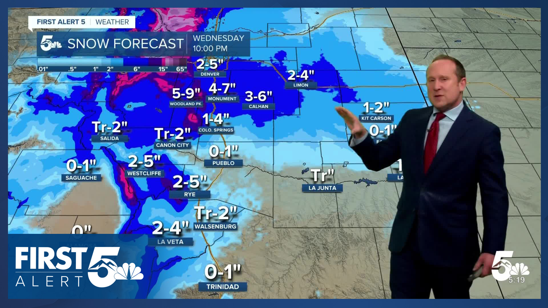
Highs on Tuesday will only warm into the middle 40s in Colorado Springs, followed by middle 30s on Wednesday. As rain changes to snow Tuesday evening, we're looking at a better chance for accumulations into Wednesday morning compared to what we saw from last week's storm. The potential for 1-4" of snow will be possible in the metro area, with locally higher totals on the north and west sides of town. Totals in Teller County look to range between 5-10", with 4-7" estimated for Monument. This is an early estimate and as high res data streams into the weather center this week, these numbers are likely to change. Spring storms are very tricky due to higher sun angles, longer days, melting, and compaction. All of this can directly affect how much sticks to the ground.
In some parts of Southern Colorado, WINTER WEATHER ADVISORIES have been issued in advance of the incoming storm.

As the storm clears out Wednesday night, it will be COLD. Overnight lows in the Springs will drop down to the middle 20s. Highs Thursday will rebound into the middle 60s, followed by a high of around 70 degrees on Friday.
____
Curious about the First Alert 5 Weather Storm Impact Scale? Check out our cheatsheet explainer.
Watch KOAA News5 on your time, anytime with our free streaming app available for your Roku, FireTV, AppleTV and Android TV. Just search KOAA News5, download and start watching.
