

Today’s Forecast:
A dome of hot sinking air is parked over the western part of the country, and will bring above average temperatures back to southern Colorado on Friday. Expect mainly sunny skies through the morning on I-25, and partly cloudy skies on the plains.
Temperatures will quickly warm to the 70s by 10 AM, and 80s before noon. The dry line - a boundary between wet and dry air, will be active today across the eastern plains. This boundary will spark a few isolated plains storms this afternoon. The cool air rushing out from these storms could push west into the Pikes Peak Region later today, which could spark a stray sprinkle. You're more likely to see evaporating rain though today due to dry low level air. The overall effect of this is that there will be an increase in PM cloud cover.
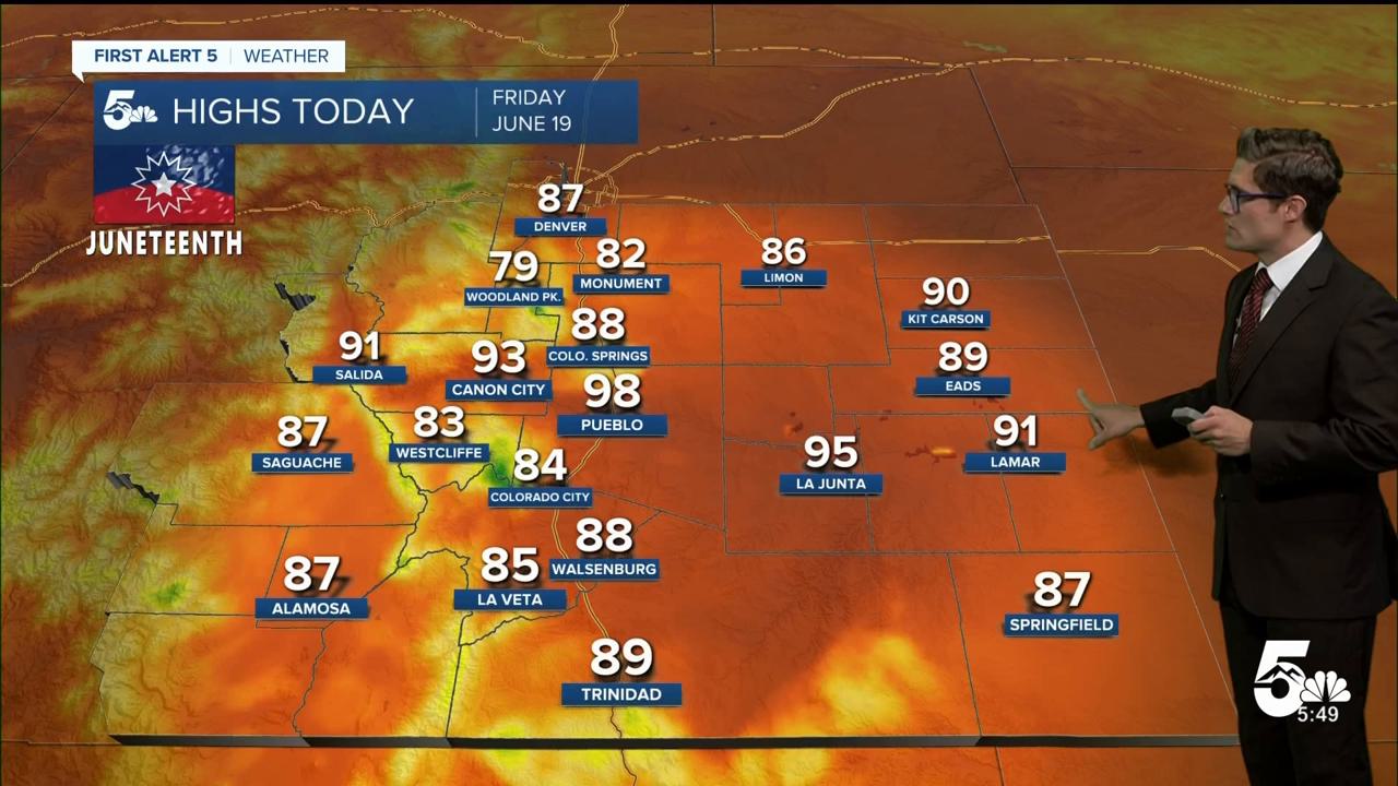
Colorado Springs forecast: High: 88; Low: 56.
Mostly sunny and -hot- today with temperatures into the 80s by noon. Northeast winds at 5-10 mph - much weaker than yesterday. Increasing clouds after 2:00 PM, with a very isolated storm possible during the late afternoon or evening. The vast majority of the area stays dry.
Pueblo forecast: High: 98; Low: 60.
Sunny and very hot. Remember to hydrate, and seek shade during the middle of the day if you can. East winds at 5-15 mph. An isolated pop up shower or weak rumbler is possible during the 2-6 PM time frame (20% chance), but don't let this distract from the main message: dry and hot!
Canon City forecast: High: 93; Low: 61.
Sunny and hot, with southeast winds at 10-15 mph. A spot shower is possible this afternoon on an otherwise dry day.
Woodland Park forecast: High: 79; Low: 50.
Sunny this morning with an isolated thunderstorm possible this afternoon. Northwest winds at 5-10 mph this morning. Southeast winds at 5-10 mph this afternoon.
Tri-Lakes forecast: High: 80s; Low: 50s.
Sunny and very warm with weak downslope northwesterly am winds at 5-10 mph, shifting to an easterly upslope after 12 PM. This corresponds with an isolated PM shower/thunderstorm chance.
Plains forecast: High: 80s/90s; Low: 60s.
Mostly sunny this morning, partly cloudy this afternoon, with an isolated stray storm this evening. While most locations will -stay dry- today, -if- you do see a storm near you, it's likely to be on the stronger side with gusty wind and small hail. So, plan accordingly. Also: significant severe weather is possible across the eastern plains on Saturday if you're planning ahead - so stay weather aware.
Walsenburg and Trinidad forecast: High: 88/89; Low: 56/59.
Sunny this morning with a stray PM t-storm possible. Northwesterly AM downslope winds shift east this afternoon and remain generally light.
Mountains forecast: High: 80s; Low: 40s/50s.
Sunny this morning, partly cloudy this afternoon with isolated thunderstorms between 1-5 PM.
Extended outlook forecast:
It will be hot with high fire danger on Saturday. Highs in the 90s and triple digits! The record high on Saturday in Colorado Springs is 97. A Fire Weather Watch is in place from 11:00 AM - 10:00 PM. Winds will be out of the southwest at 10-20 mph, gusting to 30 mph during the afternoon. Humidity will be very low. Avoid activities that could spark a wildfire!
A cold front will move through the area on Saturday night, and highs Sunday will be about 5-10 degrees cooler. Thunderstorms will be likely on Monday afternoon, with a few strong storms possible. Isolated storm chances will continue through at least Wednesday. This is very good news - the drought in southern Colorado is worsening due to the lack of moisture so far this month.
____
Curious about the First Alert 5 Weather Storm Impact Scale? Check out our cheatsheet explainer.
Watch KOAA News5 on your time, anytime with our free streaming app available for your Roku, FireTV, AppleTV and Android TV. Just search KOAA News5, download and start watching.
