

Today’s Forecast:
The snow and the cold will bring a taste of winter to our forecast today across Southern Colorado. Snow showers will be on-again/off-again across the region, heaviest from the San Juans to the Sangres to the Wets. Snow on the I-25 corridor and Plains today will be intermittent, but could be heavy at times. While accumulations will be on the light side outside of the mountains and mountain valleys, even light snow on our roadways will make driving difficult.
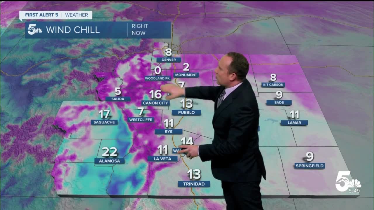
On top of the snow, it will be cold today! Highs will only warm into the 20s in most areas, with wind chill values throughout the day in the single digits and teens.
Colorado Springs forecast: High: 22; Low: 11. For today, think layers and lots of them! Temperatures will only warm into the lower 20s, with wind chill values hovering in the single digits and teens throughout the day. Snow will be the other story, with as much as 1-2" of snow in the Pikes Peak Region through Saturday afternoon.
Pueblo forecast: High: 25; Low: 12. A cold and unsettled Black Friday, with intermittent snow showers in the forecast both today and tomorrow. Snow totals from 1-2".
Canon City forecast: High: 27; Low: 15. After we saw highs in the 60s earlier this week, today's weather will serve as a reminder that it is late November, with snow and super cold temperatures and wind chills in the forecast. Snow totals from 1-3".
Woodland Park forecast: High: 21; Low: 10. Friday will be a cold and snowy one for Teller County, with periods of snow throughout the day, along with lower 20s for daytime highs. Snow totals from 1-3".
Tri-Lakes forecast: High: 10s/20s; Low: 0s/10s. With a cold and snowy forecast ahead, you might want to re-consider those outdoor plans and instead spend time indoors feasting on leftovers and putting up your holiday decorations. Snow totals from 1-3".
Plains forecast: High: 20s/30s; Low: 10s. It's hard to believe that on Wednesday we were in the 60s and 70s on the Plains. Today's forecast will be much, much colder, with highs only in the 20s. Snow showers will also fall at times today, with totals from a trace to 3".
Walsenburg and Trinidad forecast: High: 20s/30s; Low: 10s/20s. Cold, with periods of snow during the day on Friday and into the overnight hours. Travel will be slick and hazardous in some areas, especially roads that haven't been plowed or treated. Snow totals from a trace to 3".
Mountains forecast: High: 10s/20s; Low: 0s/10s. As much as 4-12" of snow will be possible for the Wet Mountains, Sangre de Cristos and our mountain valleys. This storm will bring much needed snowfall to the San Juans, with as much as 1-2 feet of snow through the day on Saturday.
Extended outlook forecast:
After waking up to temperatures in the single digits and teens Saturday morning, we'll see another cold and unsettled day of weather across Southern Colorado. A few snow showers will remain possible during the first part of the day followed by drier skies by the afternoon and evening hours. Snow totals over the next two days should stay in the 1-3" range outside of the mountains, with 4-12" of snow possible for our mountains and mountain valleys.
Highs by Sunday will return to the upper 30s and 40s, with further warming and sunshine as we look ahead to early next week. Right now, it looks like Tuesday and Wednesday will be the warmest days, with highs climbing into the lower to middle 50s on the Plains.
____
Curious about the First Alert 5 Weather Storm Impact Scale? Check out our cheatsheet explainer.
Watch KOAA News5 on your time, anytime with our free streaming app available for your Roku, FireTV, AppleTV and Android TV. Just search KOAA News5, download and start watching.
