

Today’s Forecast:
Snow will remain heaviest for the remainder of the day south of Highway 50 and for the mountain zones, with only a few flurries and snow showers this afternoon in the Pikes Peak Region and Pueblo County. Winter weather alerts remain in place. The highest totals for the remainder of the day are expected in the southeastern Plains. Some areas in the eastern Plains could still see an additional 1-4" of snow before the snow machine fully stops.
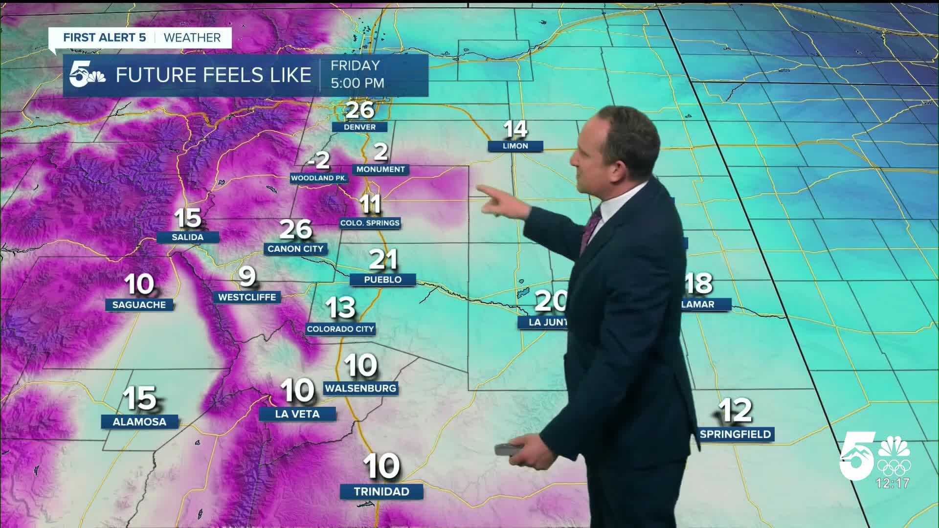
Other than the snow, it's going to be windy and cold this afternoon. Peak gusts today will be on the order of 30-40 mph. The northerly wind will keep temperatures cold, with highs only warming into the 20s and 30s on the Plains. Wind chill temperatures in the Springs today are likely to remain below 20 degrees.
Colorado Springs forecast: High: 27; Low: 7. Wind and flurries will continue this afternoon in the Pikes Peak Region, with peak northerly wind gusts to 40 mph. This may lead to white-out conditions at times due to blowing snow. Additional accumulations are not expected.
Pueblo forecast: High: 33; Low: 6. Snow will be coming to an end early this afternoon, and with clearing skies this evening, overnight lows will drop all the way down to the single digits. Wind chill temperatures could drop to below freezing by Saturday morning.
Canon City forecast: High: 32; Low: 11. A few flurries will continue through early this afternoon, but no additional accumulations are expected. For the remainder of the day and into tonight, the main story will be the cold and the wind, with peak gusts to 30 mph.
Woodland Park forecast: High: 19; Low: 2. Snow showers will come to an end this afternoon, and with clearing skies overnight tonight, low temperatures in Teller County will range from below zero to a few degree above.
Tri-Lakes forecast: High: 20s; Low: 0s. Windy and cold, with occasional snow showers through the mid and late afternoon hours. Tonight will be cold, with overnight lows dropping down to the single digits.
Plains forecast: High: 20s/30s; Low: 0s/10s. Winter Storm Warnings and Winter Weather Advisories won't expire until 5 pm, with an additional 1-4" of snow still possible today on the eastern Plains. Driving is not recommended as the wind will also be a factor in today's forecast, with 30-40 mph wind gusts.
Walsenburg and Trinidad forecast: High: 20s; Low: 0s. A Winter Storm Warning will remain in effect until 5 pm, with an additional 1-2" of snow still possible. Wind gusts to 35 mph will remain possible until late this afternoon.
Mountains forecast: High: 10s/20s; Low: -0s/0s. Winter Storm Warnings and Winter Weather Advisories will remain in effect until 5 pm for the mountains and the mountain valleys. Additional snow totals of 1-3" will be possible before the storm clears out this evening.
Extended outlook forecast:
Tomorrow morning will start out frigid, with temps in the single digits in the Pikes Peak Region, and wind chill temperatures down below zero for some. Saturday afternoon will be bright and sunny, with daytime highs rebounding into the upper 30s.
Sunday morning will start out in the upper teens followed by a high in the middle 40s in Colorado Springs.
Dry skies and a warm-up will follow early next week, allowing for temperatures to return to the 50s from Colorado Springs to the eastern Plains. We've been watching in the extended period for a chance for snow next Tuesday night to Wednesday morning, but this morning, that potential seems less likely for areas outside of the mountains.
____
Curious about the First Alert 5 Weather Storm Impact Scale? Check out our cheatsheet explainer.
Watch KOAA News5 on your time, anytime with our free streaming app available for your Roku, FireTV, AppleTV and Android TV. Just search KOAA News5, download and start watching.
