

Tonight's Forecast:
WINTER STORM WARNINGS (pink) and WINTER WEATHER ADVISORIES (purple) are in effect overnight and expire on Friday.

Expected snow totals through Friday afternoon:

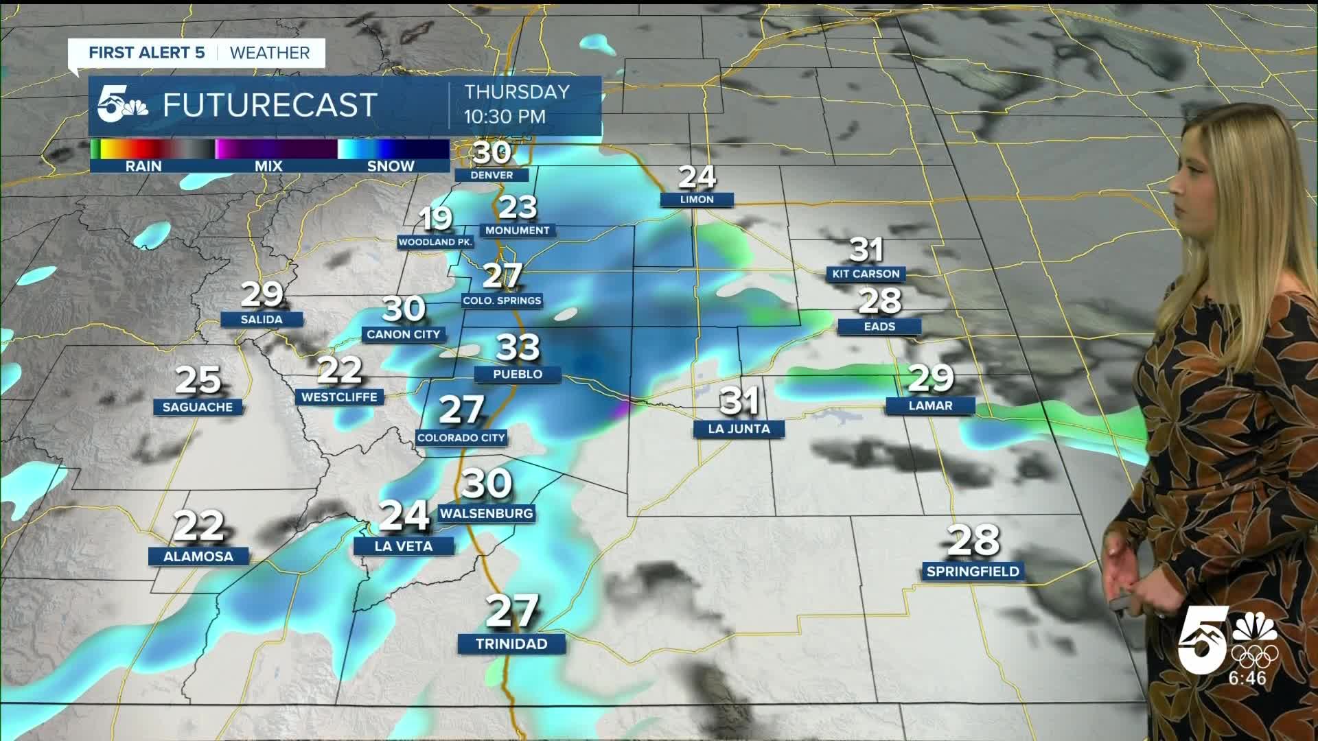
Colorado Springs forecast: Low: 23; High: 29;
WINTER STORM WARNING expires at 2 pm. Snow will come to an end in the morning. Roads will be snow-covered or icy in the morning, but improve through the day. Wind will be out of the N at 20 mph gusting to 40 mph.
Pueblo forecast: Low: 26; High: 34;
WINTER WEATHER ADVISORY expires at 2 pm. Roads will be snow-covered or icy in the morning. Snow will end by early afternoon. Wind will be blustery from the NNE at 15-20 mph, gusting to 35 mph.
Canon City forecast: Low: 28; High: 34;
WINTER WEATHER ADVISORY expires at 2 pm. Snow comes to an end by late morning or early afternoon. Wind will be out of the ENE at 5 mph gusting to 10 mph.
Woodland Park forecast: Low: 14; High: 21;
WINTER STORM WARNING expires at 11 am. Roads will be snow-covered in the morning, but the snow should come to an end in the morning as well. The sun will likely peek out in the afternoon. Wind will be out of the N at 10 mph gusting to 20 mph.
Tri-Lakes forecast: Low: 20; High: 25;
WINTER STORM WARNING expires at 11 am. The morning commute will be slippery, but the snow will end in the morning. The sun will peek out and help roads recover in the afternoon.
Plains forecast: Low: teens-20s; High: 30s;
WINTER STORM WARNING expires at 5 pm in Las Animas County. WINTER WEATHER ADVISORY expires at 2 pm in Crowley, Otero, Bent, and Prowers County. Snow will gradually come to an end from the late morning to early afternoon. Wind will be very gusty out of the N at 20 mph gusting to 40 mph, which creates low visibility where blowing snow is present.
Walsenburg and Trinidad forecast: Low: 25/22; High: 28/30;
WINTER STORM WARNING expires at 5 pm. It will be snowing until the early to mid-afternoon. Roads will likely be snow-covered for the bulk of the day. Wind will be strong on Friday afternoon from the NNE at 10-20 mph, gusting to 30-40 mph.
Mountains forecast: Low: teens-20s; High: 20s-30s;
WINTER STORM WARNING expires at 5 pm in the Wet Mountains and Spanish Peaks region. WINTER WEATHER ADVISORY expires at 5 pm for the Sangre De Cristo Range and Wet Mountain Valley. Snow will end from north to south in the mountains on Friday afternoon. Roads will remain snow-packed until plows go through and the sun peeks out.
Extended outlook forecast:
It will be very cold on Saturday morning with lows in the single digits and teens. But the sun will be back out in full force for the weekend. This will lead to warming conditions. Highs on Saturday will be in the 30s and 40s, then on Sunday in the 40s and 50s.
Mild and sunny conditions last into next week.
____
Curious about the First Alert 5 Weather Storm Impact Scale? Check out our cheatsheet explainer.
Watch KOAA News5 on your time, anytime with our free streaming app available for your Roku, FireTV, AppleTV and Android TV. Just search KOAA News5, download and start watching.
