


Tonight's Forecast: Snow will be the big story tonight as a fast-moving system moves through Southern Colorado. Several inches of snow will be possible from Woodland Park to the Palmer Divide to the Raton Mesa. Lesser amounts of around an inch or less of snow are expected from Colorado Springs to Canon City to Pueblo. The wind will be gusty at times tonight as well, with the wind and snow both expected to decrease after midnight. Across the southeast Plains, lingering snow showers will continue through early Tuesday morning.
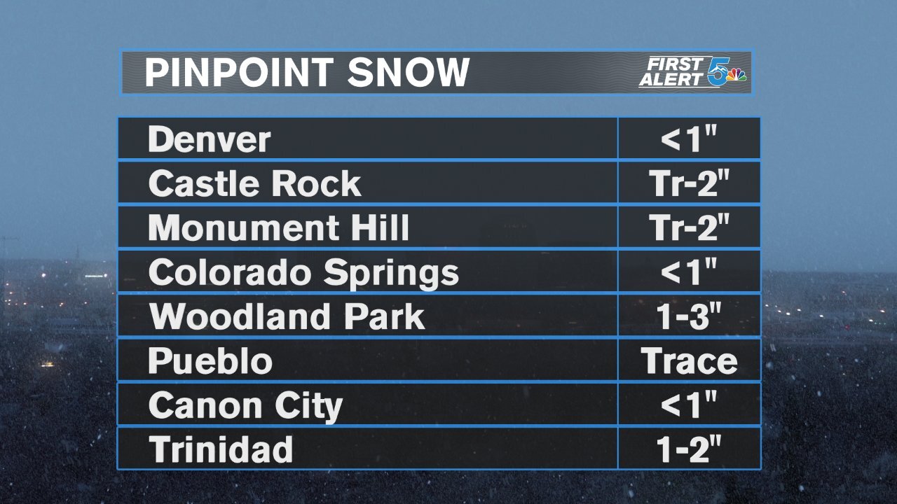
COLORADO SPRINGS: Low: 22; High: 45. Dry skies and plenty of sunshine will return to the Springs Tuesday, with a great looking forecast for our area. Northwest winds 10-15 mph.
PUEBLO: Low: 21; High: 49. Rain and snow will end around midnight. Decreasing clouds by tomorrow morning will bring us a chilly start to the day. Afternoon highs will warm to near 50 degrees.
CANON CITY: Low: 25; High: 48. Sunny skies and seasonal temperatures return on Tuesday. With highs in the upper 40s, whatever snow falls tonight should melt pretty quickly on Tuesday.
WOODLAND PARK: Low: 15; High: 40. Cold temperatures Tuesday morning, with slick and icy streets possible following tonight's storm. Highs on Tuesday will be above freezing, with plenty of sunshine.
TRI-LAKES: Low: 10s/20s; High: 30s/40s. A cold and sunny start to our Tuesday will give way to a breezy afternoon, with seasonal upper 30s and lower 40s in the forecast.
PLAINS: Low: 20s; High: 40s/50s. Snow will continue to fly across the Plains during the overnight hours, but should taper off well before sunrise. Dry skies and sunshine return on Tuesday, with highs in the 40s and 50s.
WALSENBURG/TRINIDAD: Low: 20s; High: 30s/40s. The sun returns on Tuesday, with seasonal temperatures and light winds in our forecast.
Extended Outlook: After a small break on Tuesday, unsettled weather returns on Wednesday. Snow will move into the mountains Wednesday morning, with snow or a rain/snow mix filling in across the Plains Wednesday afternoon and evening. Wednesday's storm looks to be another fast-moving system, with mostly light accumulations across the I-25 corridor. Some snow showers will linger into Thursday, followed by a sunny and cool Friday.
