


Tonight's Forecast:
Better organized bands of snow are expected to impact parts of Southern Colorado through early Tuesday morning. Most of the heavier snow will fall in the mountains and foothills, but some decent snows are also expected for Teller County, the Palmer Divide and Pikes Peak Region. Snow totals will be quite variable from this storm, but will be highest in the mountains.
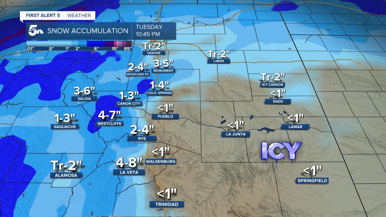
Another factor tonight will be the potential for freezing drizzle to form. We're watching the eastern parts of Las Animas County and Baca County for the greatest potential. Where this does occur, icing on roadways could be very dangerous for overnight and morning drivers.
COLORADO SPRINGS: Low: 20; High: 41. The snow is expected to come to an end before sunrise Tuesday, but depending upon how much treatment the roads receive, some commutes will be impacted. At minimum, plan to give yourself some extra time Tuesday to get to work and plan for some icy and snow packed surfaces. A second cold front Tuesday afternoon will bring the potential for gusty winds and a few light snow showers to the Pikes Peak Region. Snow totals from 1-4".
PUEBLO: Low: 22; High: 44. We won't see as much snow for Pueblo County from this current storm compared to El Paso County. Whatever does fall will taper off very early Tuesday morning, with a few snow flurries possible by late afternoon as a second cold front moves through. Snow totals for Pueblo and Pueblo West are expected to range between a trace and 2".
CANON CITY: Low: 28; High: 44. Overnight and early morning snowfall will add up to several inches for Canon City and Fremont County. Dry weather follows most of Tuesday, with a few light snow showers again possible Tuesday afternoon and evening. Snow totals from 1-3".
WOODLAND PARK: Low: 18; High: 31. Snow tonight and early Tuesday morning for Teller County. Travel will be impacted throughout the county, especially through mountain passes and the higher terrain. Tuesday will be generally dry, with a few additional snow showers late Tuesday afternoon and evening. Snow totals from 2-4".
TRI-LAKES: Low: 10s; High: 30s. Snow tonight will be heavy at times across the Palmer Divide, and as the snow continues through early Tuesday morning, our roads are expected to become snow covered and icy. Another round of light snow will be possible Tuesday afternoon and evening as a cold front passes through. Snow totals from 3-5".
PLAINS: Low: 20s/30s; High: 40s/50s. Snow will be light across the Plains tonight into Tuesday morning. The bigger concern will be the potential for freezing drizzle across Baca County and eastern parts of Las Animas County. Most of Tuesday will be dry, with the chance for a few rain/snow showers Tuesday afternoon. Snow totals generally under 1".
WALSENBURG/TRINIDAD: Low: 20s/30s; High: 40s. Much like the Plains, this will not be a big snow maker for this area. Whatever snow does fall will come to an end early Tuesday, with the potential for a second round of snow flurries Tuesday evening. Snow totals generally under 1".
MOUNTAINS: Low: 0s/10s; High: 10s/20. Mountain snow will be the big story through Tuesday afternoon. All Southern Colorado mountain ranges are either under a Winter Storm Warning or a Winter Weather Advisory until at least 11 am Tuesday. The heaviest amounts will be collected in the San Juan and Sangre de Cristo mountains. Snow totals in some areas could exceed 12-18".
Extended Outlook:
Behind Tuesday night's cold front it will turn colder. Lows Tuesday night will drop down to the 0s and 10s, and highs on Wednesday will only warm into the 20s and 30s. Modest warming is expected on Thursday, with partly cloudy skies in the forecast. Mountain snow will be possible by New Year's Eve, and as we move into New Year's Day, there's a weak chance for snow for the Plains and I-25 corridor.
