

Today’s Forecast:
Winter returns to Southern Colorado today, as a multi-part snowmaker makes its way into the area. High temperatures today have likely already been reached, with temps expected to cool this afternoon. Part one of this storm is an area of upper-level energy moving east, with a surface low well east into Kansas. The atmosphere will gain moisture through the morning due to wrap-around airflow from this first low - which you'll notice in the form of low clouds in the mountains, and a wet-cold feel to the air along I-25. Snow will begin reaching the ground across the area once the air has sufficient moisture. Teller County and the mountains will see the most consistent precipitation early today.
There is likely to be a bit of a break in our storm action in the mid-morning, as airflow shifts to a more northerly direction. A cold front will approach this afternoon, as a second upper-level system moves into the Four Corners region. More persistent showers continue in the mountains. A Winter Storm Warning begins at noon in Teller County.
As the cold front arrives, our wind direction will shift northeasterly, which is an upslope direction favorable for snow in the Pikes Peak Region. Lift from the approaching second low will assist in organizing and developing snow and cooling the upper atmosphere. All of that will allow snow to fill in and become widespread late this afternoon. The evening commute will be impacted, particularly between Colorado Springs, Monument, and Castle Rock, as well as the Ute Pass heading up toward Woodland Park. A Winter Storm Warning begins at 2:00 PM for northern El Paso County, and a Winter Weather Advisory begins at 5:00 PM for Colorado Springs.

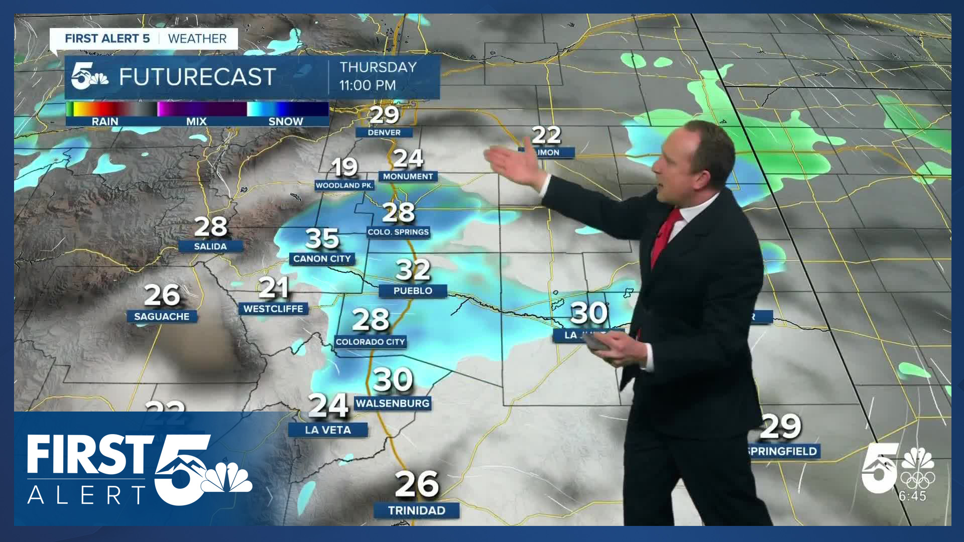
Colorado Springs forecast: High: 42; Low: 21. Our high for today was achieved already early this morning, with temps through the remainder of the day hovering in the 30s. A few rain and snow showers will be possible during the day on Thursday ahead of heavier snow tonight and Friday morning. Winter Weather Advisories will go into effect at 5 pm.
Pueblo forecast: High: 48; Low: 22. We'll see a chance today for a few rain showers, although they look to be fairly hit or miss across the metro area. By tonight, moisture increases and snow begins to fill in. The potential for heavy snow will continue through Friday morning. Winter Weather Advisories will go into effect at 5 pm.
Canon City forecast: High: 48; Low: 27. Cooler air arrives today, with temperatures expected to drop during the afternoon hours. Spotty rain and snow showers this morning and afternoon will give way to the potential for heavier snow and gusty wind late this evening. Winter Weather Advisories will go into effect at 5 pm.
Woodland Park forecast: High: 32; Low: 14. Light snow and flurries will continue at times through this afternoon before the heavier snow moves in. Both our evening commute on Thursday and the morning commute on Friday are likely to be snow covered, with slow moving traffic. A Winter Storm Warning will go into effect at 11 am.
Tri-Lakes forecast: High: 30s; Low: 10s/20s. Light snow this morning will give way to occasional light snow showers through the afternoon hours. Heavier snow will move in this evening and continue through early Friday. A Winter Storm Warning will go into effect at 11 am.
Plains forecast: High: 40s; Low: 20s. Cooler on Thursday, with showers during the day giving way to snow and gusty wind later tonight and Friday. Winter Weather alerts have been issued for Las Animas and Baca counties.
Walsenburg and Trinidad forecast: High: 30s/40s; Low: 20s. A chance for rain and snow showers will continue through this afternoon on the southern I-25 corridor ahead of increasing chances for heavy snow overnight tonight and Friday morning. A Winter Storm Warning will go into effect starting at 5 pm.
Mountains forecast: High: 30s; Low: 10s/20s. Lighter snow this morning will give way to heavier bands of snow into the late afternoon and evening hours, with periods of heavy snow continuing into Friday morning. The snow will taper off in the mountains by Friday afternoon. Winter Storm Warnings and Winter Weather Advisories will go into effect this afternoon.
Extended outlook forecast:
Snow will continue tonight, moderate to heavy at times and will accumulate. Snow continues into Friday morning and the AM commute will be significantly impacted. Friday will be windy. The gusts will begin during the morning commute around 5-6 AM, particularly over the Palmer Divide. Snow will come to an end Friday morning. Highs will be in the 20s and 30s. We expect snow totals of 3-7" in the Pikes Peak Region, and 4-8" over Monument Hill. Higher totals will occur in the mountains west of town. There's also likely to be a band of higher totals oriented east-west somewhere in the region. This is a small-scale wind-driven enhanced band effect, which means it will be difficult to predict ahead of time.


Clear skies Friday night will bring lows down to the single digits in some areas, with Saturday's temps rebounding to the upper 30s and 40s, and Sunday warming to the middle to upper 40s. Both days will be mostly sunny and the snow will melt.
____
Curious about the First Alert 5 Weather Storm Impact Scale? Check out our cheatsheet explainer.
Watch KOAA News5 on your time, anytime with our free streaming app available for your Roku, FireTV, AppleTV and Android TV. Just search KOAA News5, download and start watching.
