

Today’s Forecast:
After Sunday's cool down, temperatures will begin to ascend this afternoon ahead of another heat wave later this week. Temperatures will top out in the 60s and 70s, with most areas around 10 degrees above average.
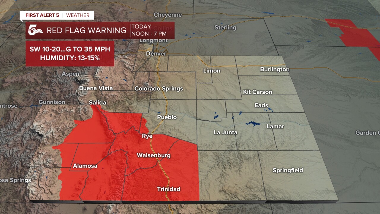
The wind will be strongest today on the eastern Plains, with S/SE wind gusts around 30-40 mph. Near and west of I-25, the wind will be variable today. It will be mostly out of the S/SE this morning, then turn to the W/SW this afternoon. It will also be gusty and dry over the southern I-25 corridor, SE mountains, and mountain valleys. These areas will be under a Red Flag Warning from 12-7 pm.
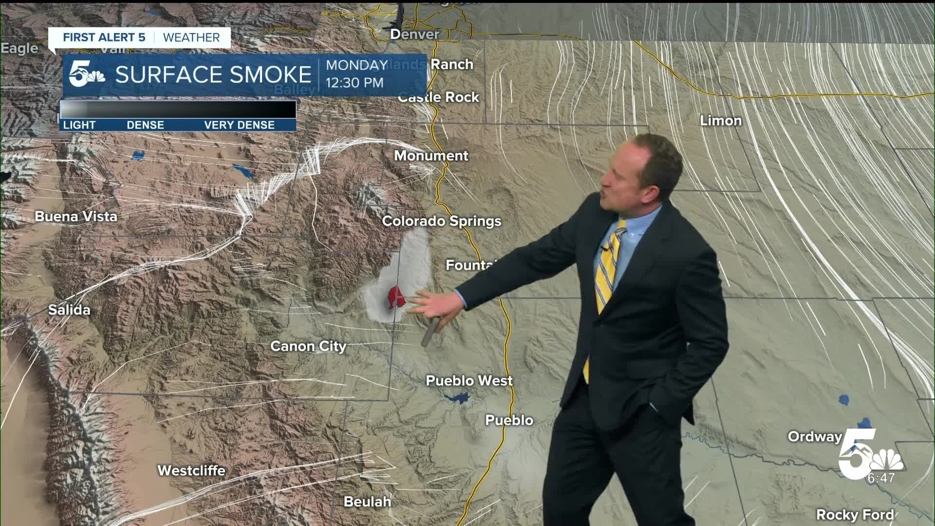
Wind gusts to 20 mph can be expected this afternoon around the 24 Fire, and this may help to transport some smoke into the Pikes Peak Region this afternoon. It should also give firefighters the upper hand on the blaze, which remains 0% contained as of 7:30 am.
Colorado Springs forecast: High: 68; Low: 42. Breezy SE winds today sustained between 10-15 mph will shift out of the W/NW towards the afternoon hours, especially for areas west of I-25. This will lead to areas of smoke this afternoon and evening, from the 24 Fire burning in Fremont County, El Paso and Pueblo counties.
Pueblo forecast: High: 73; Low: 39. After cooling down to the 60s on Sunday, highs will rebound by around 5-8 degrees from yesterday, topping out in the lower to middle 70s. Winds will be out of the east most of the day before turning more northerly this evening.
Canon City forecast: High: 72; Low: 45. Smoke from the 24 Fire will once again be visible as firefighters work hard to gain control of the fire. Today's lighter wind gusts and slightly higher relative humidity should give them a small advantage ahead of increasing wind and heat in the mid-week period.
Woodland Park forecast: High: 65; Low: 40. Southwesterly winds will be sustained between 10-15 mph, with gusts today to 20 mph. Temperatures will be warming this afternoon back into the middle 60s, which is more than 15 degrees above average.
Tri-Lakes forecast: High: 60s; Low: 30s/40s. Breezy to gusty southerly winds will be present today in northern El Paso County, with gusts east of the interstate up around 25-35 mph. Smoke from the 24 Fire will increase towards the afternoon hours, so if you are sensitive to smoke, plan indoor activities later in the day.
Plains forecast: High: 60s/70s; Low: 30s/40s. A windy and warm start to the week on the SE Plains, with S/SE wind gusts around 30-40 mph today. Temperatures will be on the rise this afternoon as well, rebounding into the upper 60s to upper 70s.
Walsenburg and Trinidad forecast: High: 60s/70s; Low: 30s/40s. Warmer and breezy on Monday, with S/SW winds today sustained at 10-20 mph. A Red Flag Warning will remain in effect from noon to 7 pm for the southern I-25 corridor.
Mountains forecast: High: 50s/60s; Low: 30s/40s. The Wet Mountains, Sangres and adjacent mountain valleys will be under a Red Flag Warning today from noon to 7 pm. Peak wind gusts this afternoon could top 35 mph in some areas.
Extended outlook forecast:
Another heat ridge will make headlines this week across Southern Colorado and the Pikes Peak Region. Temperatures will rebound into the upper 70s on Tuesday. Our current record of 74°F at the Springs Airport looks to be in jeopardy. That record dates back to 2012.
Highs in the 80s will follow from Wednesday to Thursday, with new daily records possible each afternoon. The wind will be gustier in the mid-week period, with daily wind gusts to 25 mph in Colorado Springs. Our next front will arrive Thursday night, dropping highs down to the lower 50s by Friday.
____
Curious about the First Alert 5 Weather Storm Impact Scale? Check out our cheatsheet explainer.
Watch KOAA News5 on your time, anytime with our free streaming app available for your Roku, FireTV, AppleTV and Android TV. Just search KOAA News5, download and start watching.
