


Today’s Forecast:
A cool front passed through southern Colorado early this morning but we'll feel the relief mostly in the afternoon!
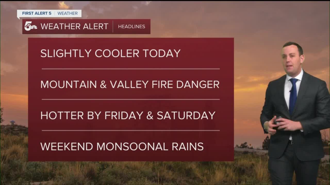
After a day of record heat with widespread 90s and 100s, today should be much more comfortable. We'll stay dry today with 80s and 90s widespread through the plains.
Smoke and air quality will be much better today with Arizona wildfire smoke staying mostly south of the state. If we do see more smoke, it'll be down near Trinidad in Las Animas County.
Red Flag Warnings remain in place west of I-25 through the Wet Mountain & San Luis Valleys, as well as the San Juans, Sangre De Cristos, and La Garita mountains.
Colorado Springs forecast: High: 87; Low: 53. Mostly sunny with scattered clouds in the afternoon. We'll be hazy in the morning with cleaner air by the end of the day. We'll stay hot and breezy through the afternoon with highs in the 80s.
Pueblo forecast: High: 95; Low: 55. Sunny and hazy in the morning with clearing skies through the afternoon. We'll still be hot today with breezy daytime conditions.
Canon City forecast: High: 90; Low: 54. Mostly sunny and hot with clearing wildfire smoke and highs in the low 90s.
Woodland Park forecast: High: 74; Low: 43. Sunny and windy with less wildfire smoke throughout the day. We'll be warm and dry with highs in the 70s.
Tri-Lakes forecast: High: 70s; Low: 50s. Mostly sunny with less daytime wildfire smoke. It'll be breezy and warm today with highs in the 70s.
Plains forecast: High: 90s; Low: 50s. Still hot across the plains with lingering wildfire smoke and poor air quality south of Highway 50. Drink lots of water as we'll see daytime highs in the 90s.
Walsenburg and Trinidad forecast: High: 80s; Low: 50s. Breezy and hot with lingering wildfire smoke from fires in Arizona and New Mexico. The smoke will be weaker than yesterday, but we could still see haze and poor air quality in the afternoon with temperatures warm into the 80s.
Mountains forecast: High: 70s; Low: 40s. High Fire Danger today with Red Flag Warnings through the afternoon. Windy and dry conditions will mean if a fire sparks, it could spread quickly.
Extended outlook forecast:
Wednesday looks really nice with dry skies and highs in the 80s and 90s.
Summer heat returns on Friday and Saturday with highs back in the 90s and maybe a few triple digits east of Pueblo.
Monsoonal type rains will return over the weekend with most of the moisture flooding into the mountains. We'll see scattered storms pop out into the foothills and I-25 corridor over the weekend with not much rain expected to move east of I-25.
____
Curious about the First Alert 5 Weather Storm Impact Scale? Check out our cheatsheet explainer.
Watch KOAA News5 on your time, anytime with our free streaming app available for your Roku, FireTV, AppleTV and Android TV. Just search KOAA News5, download and start watching.