

Tonight's Forecast:
A mixed bag of weather will continue this evening, with a Red Flag Warning in effect until 8 pm for the Akransas River Valley, southeastern mountains, mountain valleys and eastern Plains. Occasional rain showers and thunderstorms will remain possible until around sunset for the Pikes Peak Region, with a low end risk of both severe hail and severe wind gusts. Thankfully, the worst of the severe weather should stay off to our north and east tonight, where several counties are under a Severe Thunderstorm Watch until 10 pm.
Skies should clear out locally overnight tonight, with lows dropping down to the 40s and 50s. The colder mountain valleys will see temperatures bottom out in the 30s.
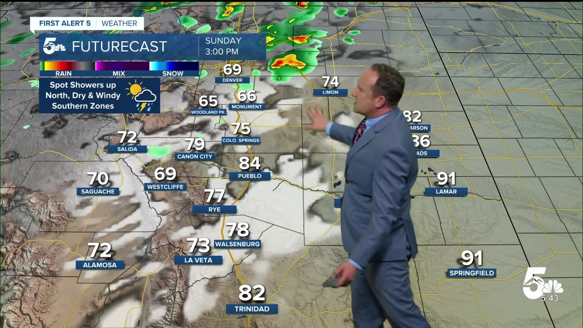
Colorado Springs forecast: Low: 50; High: 75; Sunday's forecast will be a near repeat performance of what we saw today. Skies will be bright and sunny early before turning overcast. While storms will be spotty in nature, any storms that do pulse up could reach low end severe criteria, with 1" hail and gusts to 60 mph.
Pueblo forecast: Low: 52; High: 84; Warm, dry and windy weather returns to the Steel City on Sunday, with a Red Flag Warning in effect from 10 am to 9 pm.
Canon City forecast: Low: 53; High: 81; The upper Arkansas River Valley will once again see Red Flag Warning conditions on Sunday, with a warning in effect from 10 am to 9 pm. Peak gusts in the afternoon could top 35 mph.
Woodland Park forecast: Low: 41; High: 67; Sunshine in the morning will give way to increasing clouds and a chance for showers and thunderstorms by early to mid afternoon. While storms won't be numerous in Teller County, any storms that do form could reach severe strength.
Tri-Lakes forecast: Low: 40s/50s; High: 60s/70s; The Palmer Divide will see another round of scattered showers and thunderstorms Sunday afternoon, with the potential for a few strong to severe storms across the region.
Plains forecast: Low: 40s/50s; High: 80s/90s; Rain threats should stay well north of the southeastern Plains on Sunday, with high winds and high fire danger our main form of "weather to watch". A Red Flag Warning will remain in effect on Sunday from 10 am to 9 pm.
Walsenburg and Trinidad forecast: Low: 50s; High: 70s/80s; Dry, windy and warm weather can be expected to return on Sunday. A Red Flag Warning will remain in effect for Las Animas and Huerfano counties from 10 am to 9 pm.
Mountains forecast: Low: 30s/40s; High: 60s; More wind and high fire danger will plague the southeastern mountains on Sunday, with Red Flag Warnings back in effect from 10 am to 9 pm. Peak gusts in the higher terrain will range between 40-50 mph.
Extended outlook forecast:
As the initial system pivots through the state on Monday, it will bring us a cooler, windy and unsettled changes to start to the week. Temperatures on Monday will only warm into the middle to upper 50s in Colorado Springs, with periods of rain. Snow levels should stay at or above 8,000 feet, with a wintry mix or snow at times into Teller County and norther parts of El Paso County.
The threat of a freeze will follow Tuesday morning across some neighborhoods in Colorado Springs. Highs on Tuesday will only warm into the lower to middle 50s, with showers increasing by the evening hours. Additional chances for rain will follow Wednesday and Thursday, with highs eventually returning to the 60s by Thursday afternoon.
In higher elevation areas of the state, several rounds of snow will be possible from Monday morning until the middle of next week. It looks like good moisture for some areas, especially northern Colorado.
____
Curious about the First Alert 5 Weather Storm Impact Scale? Check out our cheatsheet explainer.
Watch KOAA News5 on your time, anytime with our free streaming app available for your Roku, FireTV, AppleTV and Android TV. Just search KOAA News5, download and start watching.
