

Today’s Forecast:
As monsoon moisture re-develops on Tuesday across Colorado, we can expect a more active day weather wise. Thunderstorms look to form ahead of the lunch hour in the mountains, with rain possible today in Woodland Park as early as 11 am to 1 pm. Showers and thunderstorms will move slowly to the east, with the main threats of rain in Colorado Springs between 1-7 pm. Storms today will be capable of locally heavy rainfall, small hail, gusty winds and frequent lightning. Outdoor plans are likely to be impacted at some point today.
Temperatures today will be cooler after near record heat on Monday. Highs will warm into the 70s and 80s in the mountains and valleys, with 80s, 90s and lower 100s on the Plains.
Colorado Springs forecast: High: 86; Low: 59. After a stunning and mild sunrise this morning, our weather today will turn cooler and more unsettled as the potential for intense thunderstorms and heavy rainfall returns to our forecast.
Pueblo forecast: High: 93; Low: 62. Yesterday's high of 101 degrees was nearly hot enough to break a record, but came up short by two degrees. Today will be around 8 degrees cooler, with scattered thunderstorms possible this afternoon and evening.
Canon City forecast: High: 90; Low: 64. Mild and muggy this morning...a sign of the monsoon making a comeback across Southern Colorado. This will allow for more widespread showers and thunderstorms this afternoon, with any threats of rain coming to an end around sunset.
Woodland Park forecast: High: 77; Low: 48. Cooling highs and increasing moisture will bring the potential for a wet afternoon to Teller County on Tuesday, with thunderstorms forming as early as the late morning hours.
Tri-Lakes forecast: High: 70s/80s; Low: 50s. After a hot weekend and toasty Monday, highs today will be around 6-10 degrees cooler, with today's cool down partially to blame on increasing chances for rain and thunderstorms this afternoon.
Plains forecast: High: 90s/100s; Low: 60s. Still hot on the Plains, with dry skies this morning giving way to the potential for late afternoon and evening thunderstorms. Some of the more intense thunderstorms today will bring the potential for heavy rainfall, gusty winds, small hail and frequent lightning.
Walsenburg and Trinidad forecast: High: 80s/90s; Low: 50s/60s. Increasing monsoonal moisture will bring the potential for slow moving thunderstorms and heavy rain today to the southern I-25 corridor. Storms will also be capable of small hail, gusty winds and frequent lightning.
Mountains forecast: High: 60s/70s; Low: 40s/50s. Increasing moisture on Tuesday will mark the start of a more active period of weather for the state, which will include the potential for heavy rain today in the mountains. Storms look to fire off as early as late this morning.
Extended outlook forecast:
As sub-tropical moisture continues to increase, the mid-week period will turn wet, with further cooling to our highs. Wednesday's high in Colorado Springs will warm to near 80 degrees, with highs in the middle to upper 70s both Thursday and Friday. Highs on the Plains late this week will warm into the lower to middle 80s.
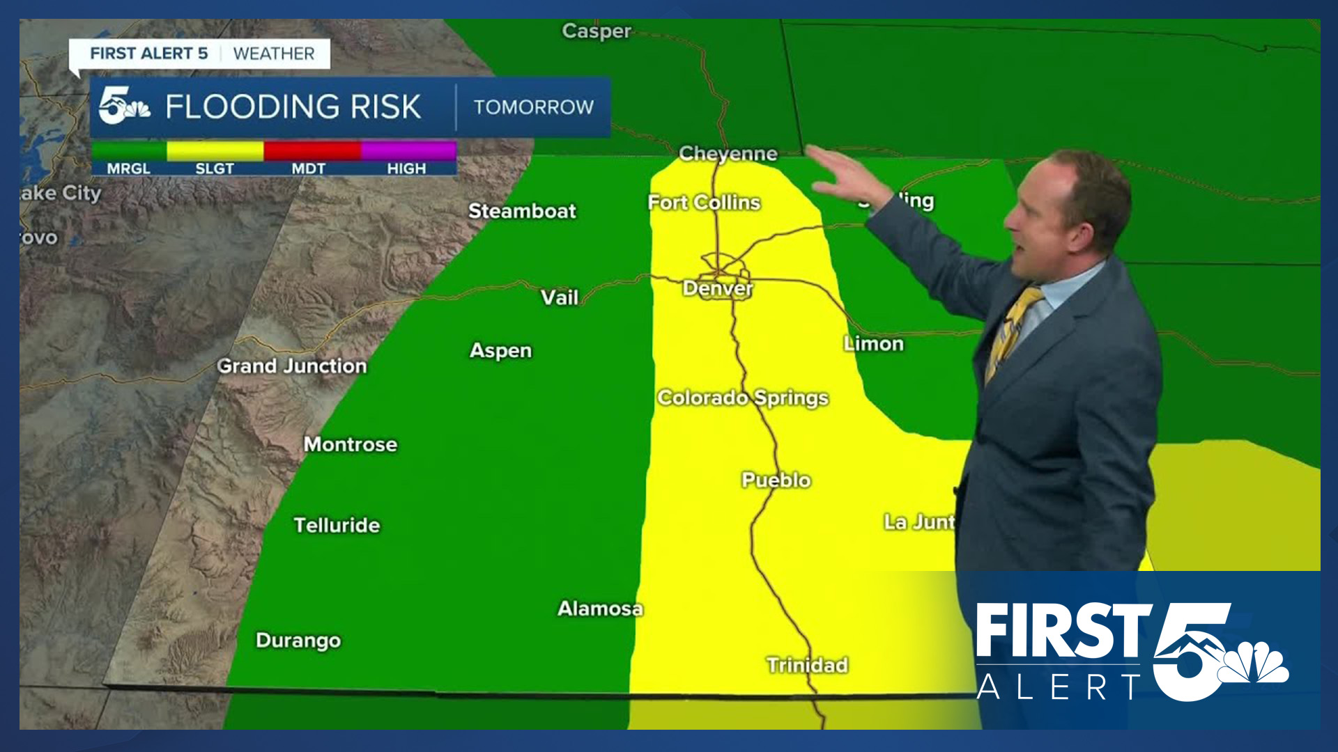
A few showers or areas of drizzle will be possible Wednesday morning in the Pikes Peak Region, with the bulk of the rain expected towards Wednesday evening. Slow moving storms on Wednesday may increase the risk of flash flooding in some areas, where locally heavy rainfall could lead to street flooding. Another round of heavy rain will be possible on Thursday, with scattered storms, but less intense rainfall by Friday. Drying skies are expected this weekend, with a few isolated storms still in play on Saturday.
____
Curious about the First Alert 5 Weather Storm Impact Scale? Check out our cheatsheet explainer.
Watch KOAA News5 on your time, anytime with our free streaming app available for your Roku, FireTV, AppleTV and Android TV. Just search KOAA News5, download and start watching.
