

Tonight's Forecast:
Overnight will be partly cloudy to mostly clear with light wind and mild temperatures.
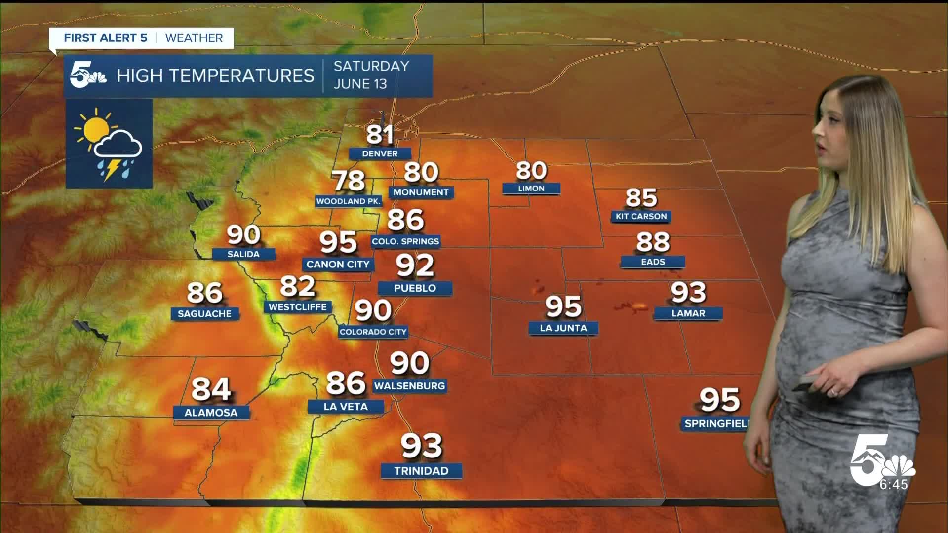
Colorado Springs forecast: Low: 56; High: 86;
Saturday will be hot and partly cloudy. There is a low chance of a late afternoon shower or isolated thunderstorm. Wind will be out of the NE at 10-15 mph, gusting 25-30 mph.
Pueblo forecast: Low: 57; High: 92;
RED FLAG WARNING from 11 am until 7 pm on Saturday. It will be mostly sunny with a low chance of an afternoon dry thunderstorm. Wind will be out of the ENE at 10-15 mh gusting to 30 mph.
Canon City forecast: Low: 61; High: 95;
It will be partly cloudy and warm on Saturday. Wind will be variable at 10-15 mph, gusting to 30 mph. There is a low chance of an evening shower and isolated thunderstorm.
Woodland Park forecast: Low: 50; High: 78;
It will be partly cloudy with a low chance of an afternoon or evening shower. Otherwise, warm with a NE breeze at 10 mph gusting to 20 mph.
Tri-Lakes forecast: Low: 54; High: 80;
It will be partly cloudy on Saturday with a low chance of an afternoon shower. Wind will be out of the ENE at 10 mph gusting to 25 mph.
Plains forecast: Low: 50s-60s; High: 80s-90s;
It will be mostly sunny to partly cloudy on Saturday with NE wind at 10-15 mph gusting 25-40 mph. Rain moves in overnight.
Walsenburg and Trinidad forecast: Low: 62/58; High: 90/93;
It will be partly cloudy on Saturday with warm temperatures and a light breeze. There is a low chance of an afternoon or evening isolated shower.
Mountains forecast: Low: 40s-50s; High: 70s-80s;
The mountain valleys will be partly cloudy and warm on Saturday. Wind will be out of the WNW at 10-15 mph, gusting to 20-25 mph. Spotty light showers and isolated thunderstorms are possible in the afternoon and evening.
Extended outlook forecast:
Sunday will be much different with an increase in clouds and rain. The day starts with morning rain showers, favoring zones south of HWY 50 and in the SE plains. There will be a break in precipitation from late morning to early afternoon. Then a couple of rounds of thunderstorms will develop in the mountains and move east to I-25 through the mid-afternoon to the evening.
____
Curious about the First Alert 5 Weather Storm Impact Scale? Check out our cheatsheet explainer.
Watch KOAA News5 on your time, anytime with our free streaming app available for your Roku, FireTV, AppleTV and Android TV. Just search KOAA News5, download and start watching.
