



COLORADO SPRINGS, Colo. (KOAA) — Today’s Forecast:
It will be hot again today in southern Colorado. Skies will be sunny, and it will be breezy during the afternoon. Winds will be southeasterly.
High pressure is anchored well north of Colorado in the north central US, bringing upslope flow to southern Colorado but with overall temperatures still slightly above average.
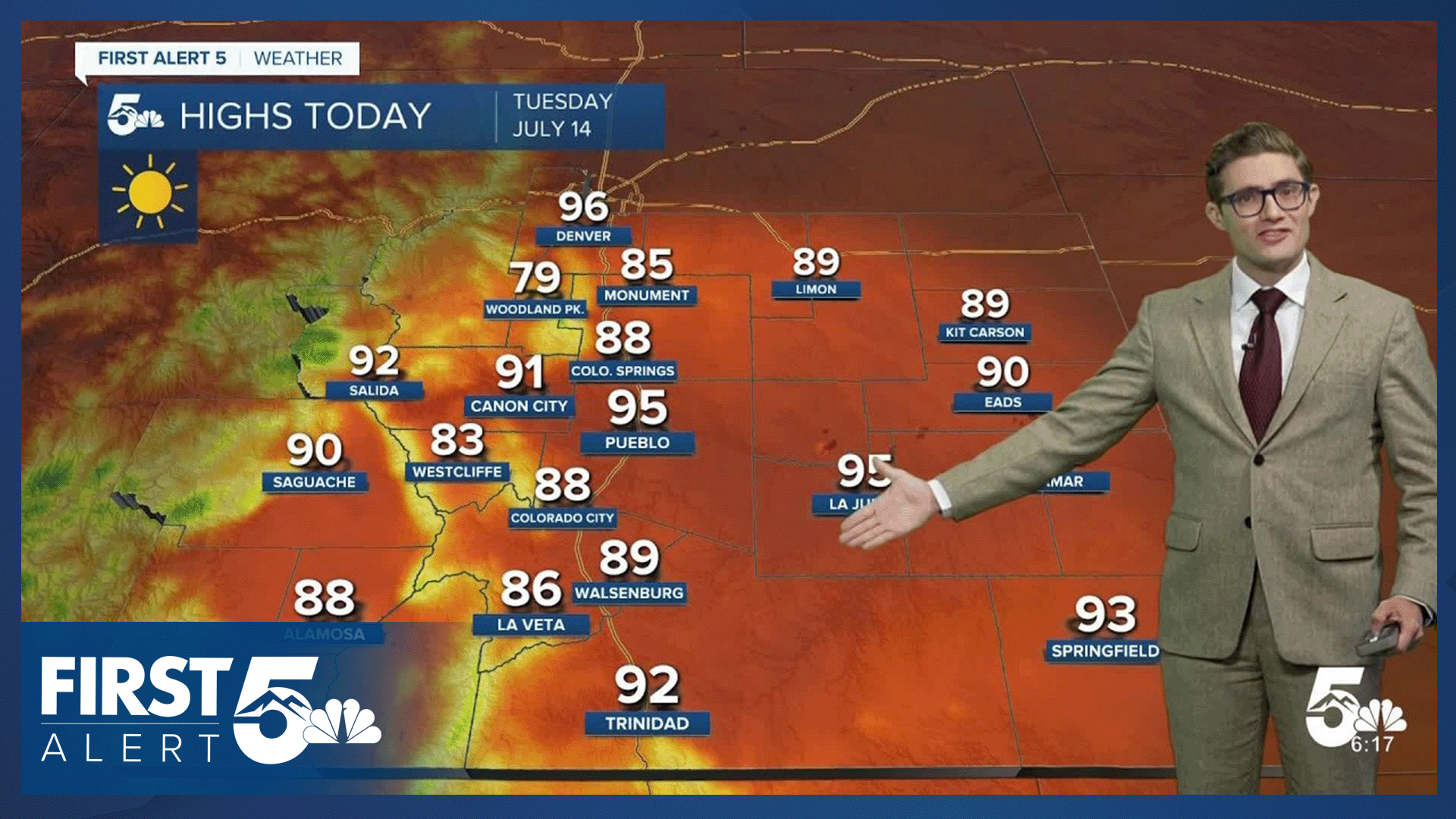
Colorado Springs forecast: High: 88; Low: 56.
Sunny and breezy. A good day for a cowboy hat at the Pikes Peak or Bust rodeo...or a nice day to head to the pool! Southeast winds mostly notable in the afternoon hours at 10-20 mph, gusting to 25-30 mph in the late afternoon and early evening.
Pueblo forecast: High: 95; Low: 64.
Sunny, hot, and dry. East southeast winds at 10-20 mph, gusting 30-35 mph this afternoon.
Canon City forecast: High: 91; Low: 62.
Sunny and hot! Early or late outdoor exercise or dog walks will be most comfortable today, though it stays quite warm well after sunset too. Breezy this afternoon with an east southeast wind at 10-20 mph, with a few 25 mph gusts sprinkled in.
Woodland Park forecast: High: 79; Low: 49.
Sunny and warm. East winds shifting southeast this afternoon at 5-15 mph, gusting to 20 mph.
Tri-Lakes forecast: High: 80s; Low: 50s.
Sunny and breezy with east southeast winds shifting southeast this afternoon at 10-20 mph, gusting to 30 mph this evening.
Plains forecast: High: 80s/90s; Low: 50s/60s.
Sunny, hot, and gusty. Southeast winds at 10-20 mph, gusting to 35 mph this afternoon.
Walsenburg and Trinidad forecast: High: 89/92; Low: 60/59.
Sunny with northwest winds at 5-10 mph, shifting east this afternoon.
Mountains forecast: High: 70s/80s; Low: 50s.
Sunny with smoke due to the Aspen Acres fire, winds east southeast at 10-20 mph and gusting to 35 mph this afternoon. Some clouds in the central mountains and an isolated terrain driven shower is also possible.
Extended outlook forecast:
The upper ridge will continue to bring consistently hot, breezy and dry weather to the region through Thursday. The breezes will reduce Friday as the high starts to break down a bit with a new center reforming over Wyoming. This changes the upper-level wind pattern, and will also boost temperatures a few degrees late this week. The closer to the center of the ridge we are, the hotter we get. This leads to highs in the 5-10 degree above average range by Friday and Saturday.
This weekend, monsoon moisture begins to make its appearance here in southern Colorado. That moisture is already somewhat impacting the San Juan range in the southwestern part of the state. An isolated storm or two is possible up in Teller County on Saturday, with that moisture moving into the Pikes Peak Region Sunday, and more widespread storm chances are likely for much of southern Colorado next week.
____
Curious about the First Alert 5 Weather Storm Impact Scale? Check out our cheatsheet explainer.
Watch KOAA News5 on your time, anytime with our free streaming app available for your Roku, FireTV, AppleTV and Android TV. Just search KOAA News5, download and start watching.
