


Tonight's Forecast:
The stage will be set for a chilly night across Southern Colorado, with clear skies and weakening winds after sunset. Overnight lows will fall below freezing in the lower elevations, with single digits and teens on tap for the coldest mountain and mountain valley locations.
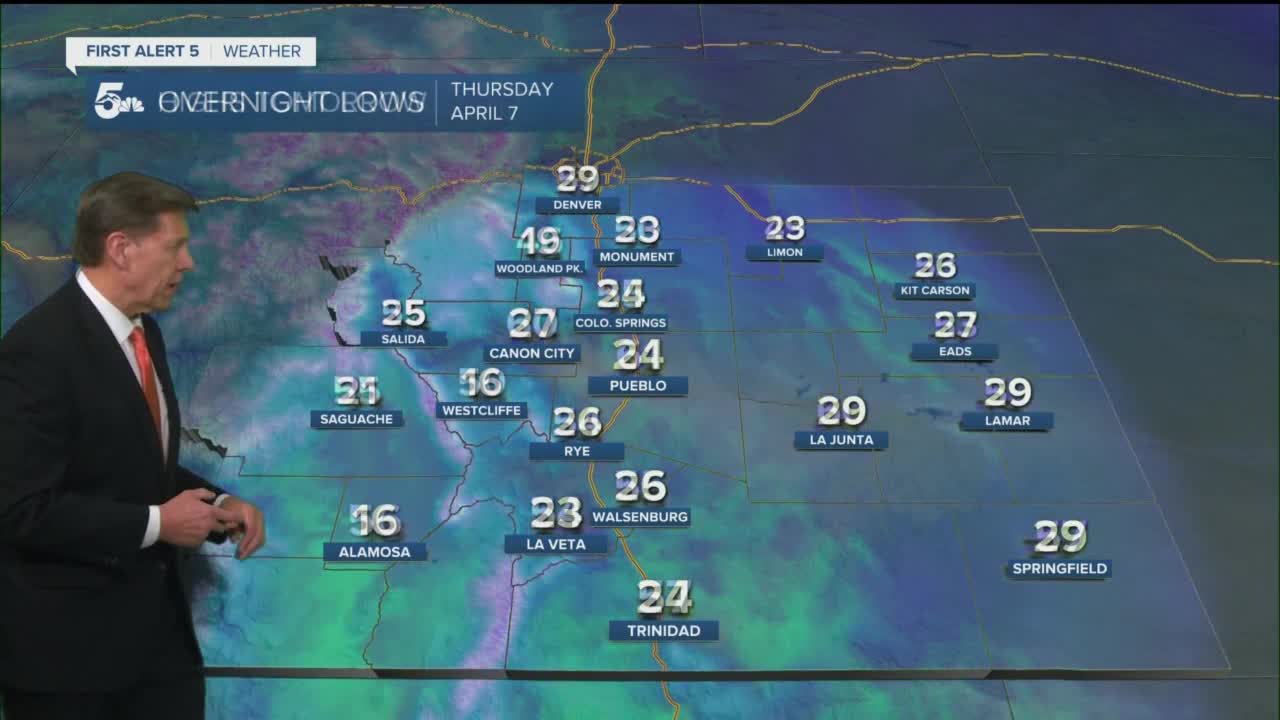
Colorado Springs forecast: Low: 26; High: 55; More strong and gusty winds for the Pikes Peak Region on Thursday, with afternoon wind gusts up to 45 mph. A Red Flag Warning will go back into effect at 11 am due to the combination of high winds and low relative humidity.
Pueblo forecast: Low: 24; High: 60; Sunshine and strong winds will return on Thursday, with peak afternoon wind gusts up near 45 mph. We'll also see another round of Red Flag Warnings during the day as well for Pueblo County.
Canon City forecast: Low: 27; High: 60; Sunny and windy on Thursday, with near average highs on tap for eastern Fremont County. Peak afternoon wind gusts tomorrow could top 40 mph.
Woodland Park forecast: Low: 19; High: 46; The wind will be back for another gusty and cool day for Teller County, with peak afternoon wind gusts from 35-50 mph.
Tri-Lakes forecast: Low: 20s; High: 40s/50s; Another day of windy weather on Thursday, with peak afternoon wind gusts soaring to 50 mph across northern El Paso County.
Plains forecast: Low: 20s; High: 50s/60s; Extremely windy once again for the Plains on Thursday, with high fire danger and areas of blowing dust in the forecast. The sunshine will make it look nice, but the wind will continue to be a real nuisance in the forecast.
Walsenburg and Trinidad forecast: Low: 20s; High: 50s; Instead of shaking the wind on Thursday, Mother Nature will keep the wind machine cranking throughout the day, with a new Red Flag Warning set to go into effect starting at 11 am.
Mountains forecast: Low: 10s; High: 30s/40s; Another wind-whipped afternoon for the Wet Mountains and Sangre de Cristos. Peak wind gusts over the high country will range from 40-55 mph during the day.
Extended outlook forecast:
After a long stretch of windy weather, a calmer forecast pattern is set to move into Southern Colorado by Friday, with highs warming into the 60s. Saturday will be the real deal with temperatures soaring into 70s and 80s. Breezy to windy conditions are set to return Sunday and Monday with the potential for more Red Flag Warnings in parts of Southern Colorado.
A pretty big change could follow around the middle of next week, with the potential for soaking rains and heavy snow. We're watching it closely and will keep you posted!
____
Curious about the First Alert 5 Weather Storm Impact Scale? Check out our cheatsheet explainer.
Watch KOAA News5 on your time, anytime with our free streaming app available for your Roku, FireTV, AppleTV and Android TV. Just search KOAA News5, download and start watching.
