

Today’s Forecast:
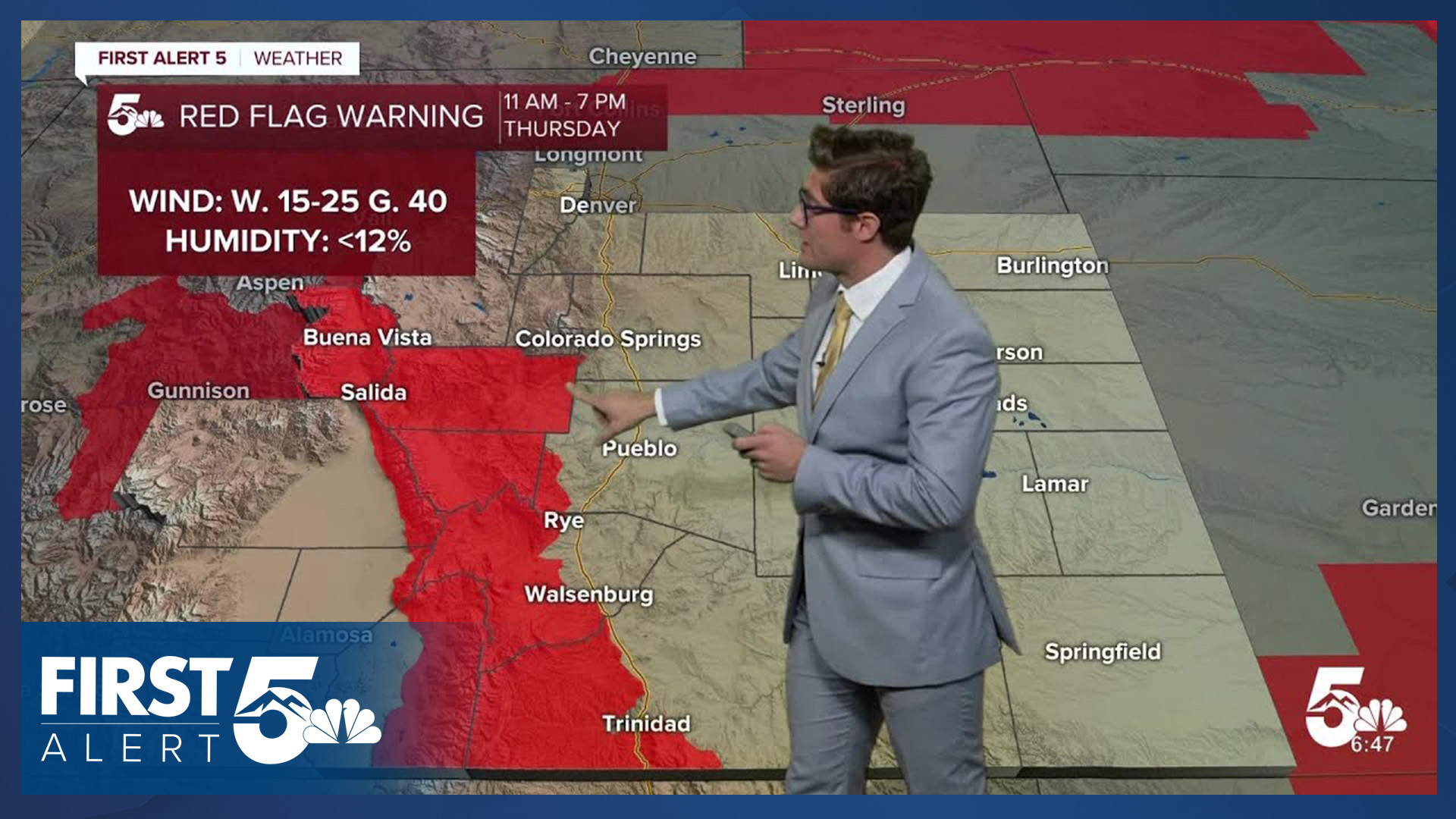
High pressure is shifting east today, and as it does so, mid-level winds are increasing across the state. This will lead to downslope winds across the central and southern mountains, with Red Flag Warnings in place for these zones and Fremont County from 11:00 AM - 7:00 PM. Avoid outdoor burning, and activities that could produce a spark, in these areas.
Skies today will be partly cloudy due to wave clouds and a weak mid-level disturbance. Temperatures are quite warm already thanks to the downslope breeze. This afternoon, clearer skies, the downslope wind, and mixing all lead to another hot day with highs in the 80s to 90s.
Colorado Springs forecast: High: 85; Low: 52.
Some beautiful lenticular cloud structures early today over the Colorado Springs area. These will not last all day but skies will remain partly cloudy this afternoon. Winds will generally be westerly at 10-15 mph.
Pueblo forecast: High: 91; Low: 51.
Another hot day, with mostly cloudy skies early becoming partly cloudy by the afternoon. It will be a bit breezy this afternoon with downslope compressional westerly winds at 10-20 mph, with a few 25 mph gusts possible.
Canon City forecast: High: 89; Low: 53.
RED FLAG WARNING in effect from 11:00 AM - 7:00 PM
Breezy, hot, and dry today leading to high fire danger. Therefore, avoid outdoor burning today and activities that could generate sparks. West winds, sustained at 10-20 mph, gusting to 30 mph this afternoon. Otherwise, partly cloudy skies.
Woodland Park forecast: High: 74; Low: 42.
Partly cloudy and warm once again. West winds at 10-15 mph.
Tri-Lakes forecast: High: 80s; Low: 50s.
Partly cloudy with westerly winds at 10-15 mph.
Plains forecast: High: 90s; Low: 50s.
Decreasing clouds through the day, with isolated thunderstorms possible after 2:00 PM. These storms are more likely the further southeast you are in the state - with the best chance in Baca county. Otherwise, breezy with west winds at 15-25 mph.
Walsenburg and Trinidad forecast: High: 84/87; Low: 53/51.
Partly cloudy and gusty with west winds at 15-25 mph. Most of the more notable wind gusts will be during the morning.
Mountains forecast: High: 70s; Low: 40s/50s.
RED FLAG WARNING in effect from 11:00 AM - 7:00 PM
Partly sunny, gusty, dry, and warm with west winds at 15-25 mph gusting to 40 mph. Avoid outdoor burning and other activities that could start a wildfire.
Extended outlook forecast:
It will be a cooler evening due to lighter overnight winds but still mild - with most cities along the southern Front Range bottoming out in the low 50s. Potentially a decent "open windows" type of evening.
On Friday, highs will be cooler in the low 80s with partly cloudy skies.
On Saturday, a weak mid-level disturbance will lead to the chance for an isolated storm or two. The Storm Prediction Center does have Colorado Springs and portions of Pueblo in a 1-out-of-5 marginal risk for severe weather, which is to say that storms are not guaranteed, but if one does manage to form it could produce gusty wind. Highs will be in the upper 70s. There is a slightly higher potential for strong storms across the eastern plains.
We'll continue to see a chance for isolated storms Sunday as an upper level low moves toward the state, and it will be breezy.
On Monday storms will be slightly more widespread as we continue to track the upper level low. Highs will be -much- cooler in the middle 60s.
____
Curious about the First Alert 5 Weather Storm Impact Scale? Check out our cheatsheet explainer.
Watch KOAA News5 on your time, anytime with our free streaming app available for your Roku, FireTV, AppleTV and Android TV. Just search KOAA News5, download and start watching.
