

Today’s Forecast:
It will be very dry and partly cloudy, with increasing wind today. Fire danger will be high. Red Flag Warnings begin at 11 am, and remain in effect until 6 pm.
Wave clouds have developed this morning as strong upper-level winds...yet again...overspread the Front Range. In addition, a weak warm frontal boundary is slowly pushing east across the Plains. Downslope breezes have been light to moderate so far this morning in the Springs and Pueblo, with stronger gusts already beginning to surface near the higher terrain.
Westerly winds will increase region-wide late this morning. This afternoon, they'll be sustained at 15-25 mph, gusting 35-50 mph. Humidity will drop to 10-15%. If you see smoke, call 911 - it should not be there.
Highs will climb close to records - reaching the upper 60s in the Pikes Peak Region, and record-breaking warmth is likely today. Today's record in Colorado Springs is 67 degrees. Pueblo's high is expected to climb into the lower 70s.
It will remain gusty this evening, especially near the mountains. The wind gusts will be erratic - with periods of strong gusts, and periods of relatively calm wind. If you're near the mountains, the wind overnight will be stronger than the wind you see during the daytime.
Colorado Springs forecast: High: 67; Low: 41. Today's forecast in the Pikes Peak Region will be dry and windy, with a Red Flag Warning in effect from 11 am until 6 pm. 30-40 mph gusts will be possible this afternoon with relative humidity around 10-15% for several hours in Colorado Springs.
Pueblo forecast: High: 72; Low: 38. Warm and windy, with another Red Flag Warning being issued today for Pueblo County from 11 am until 6 pm. Pueblo's record high of 70 degrees looks to get broken pretty easily today. This record dates all the way back to 1917.
Canon City forecast: High: 70; Low: 44. Red Flag Warnings will go into effect in Fremont County at 11 am, lasting until 6 pm. Gusts around 35-45 mph and humidity in the teens may prove problematic if a fire were to break out.
Woodland Park forecast: High: 57; Low: 35. It looks like the wind will be toned down a few notches from Wednesday, but for Woodland Park on Friday, peak gusts today and tonight could still top 50 mph.
Tri-Lakes forecast: High: 60s; Low: 30s/40s. Friday will windy and dry, with a Red Flag Warning in effect during the day. Even as the Red Flag Warning expires at 6 pm, more strong wind looks to continue this evening.
Plains forecast: High: 60s/70s; Low: 30s/40s. Even though the calendar says that it's December 19, today will look and feel a lot more like October. On the Plains, we'll see a windy and warm day, with a Red Flag Warning in effect from 11 am until 6 pm.
Walsenburg and Trinidad forecast: High: 60s; Low: 40s. I hate to sound like a broken record, but after our cool down on Thursday, we're expecting another warm and windy day on the southern I-25 corridor, with another Red Flag Warning being issued.
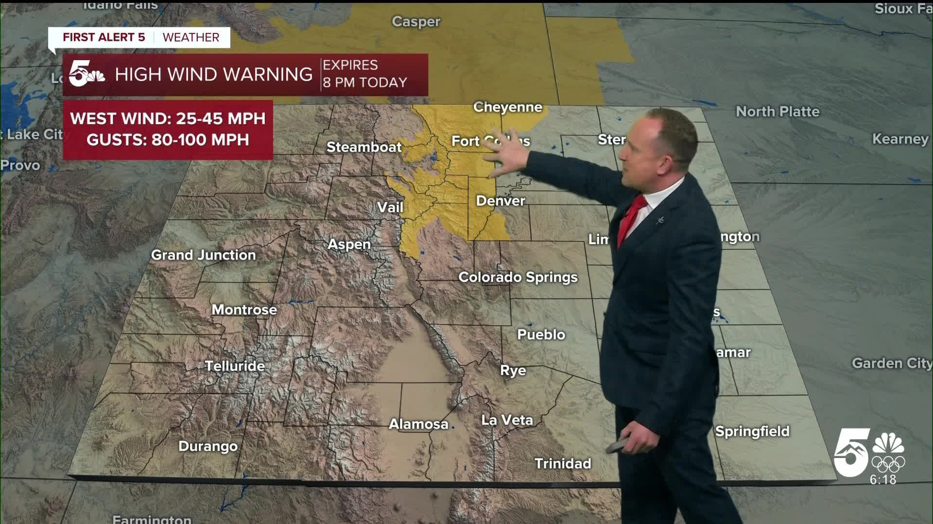
Mountains forecast: High: 40s; Low: 20s/30s. It's already been windy this morning and the wind won't stop today or tonight in the mountains, with peak gusts between 45-60 mph. To the north of us, High Wind Warnings have been issued for the Front Range mountains and foothills, with peak gusts in these areas around 80-100 mph.
Extended outlook forecast:
Saturday brings yet more wind to the forecast, and more warmth. It will be gusty through the early afternoon, with winds progressively dropping back through the day. A shallow front will move through the northeastern plains in the morning, with some of that cold air pushing west in the late afternoon and evening. Skies will be partly cloudy.
Sunday is cooler due to the cool air intrusion from the east, with highs in the 50s in the lower elevations, and much less wind.
Downslope breezes return Monday, leading to more warmth and elevated fire danger. Highs will be in the 60s and lower 70s region-wide.
60s continue to Christmas Day, with lows likely to remain above freezing next week. A white Christmas is very unlikely in the Pikes Peak Region.
There are signs of a pattern change in the mountains by Christmas though, with some snow likely toward the end of the week.
____
Curious about the First Alert 5 Weather Storm Impact Scale? Check out our cheatsheet explainer.
Watch KOAA News5 on your time, anytime with our free streaming app available for your Roku, FireTV, AppleTV and Android TV. Just search KOAA News5, download and start watching.
