

Today’s Forecast:
The calendar says February — but it will feel like May on Tuesday in Southern Colorado, with another round of Red Flag Warnings ahead. You're walking outside to temperatures 15 to 25 degrees warmer than this time on Monday. This afternoon, highs will climb into the 70s and 80s on the Plains. The current record high in Colorado Springs is 71, set in 1986. We are likely to break that record today. Parts of the southeast plains are likely to hit 80 degrees today.
This will be the 6th day this month with Red Flag Warnings in Southern Colorado. The last time there were 6 or more Red Flag Warning days in Southern Colorado in February was in 2017, when there were 10.
Winds will increase late this morning with west, northwest downslope flow and lee troughing. That means low pressure at the ground across the Plains — a setup that helps to mix wind down from the upper atmosphere. As usual in this setup, the gustiest conditions will be in and just east of the mountains. In Colorado Springs, expect afternoon wind gusts to 35 mph. Humidity will drop below 15% this afternoon leading to elevated to critical fire danger. Red Flag Warnings will be in effect from 10:00 AM - 6:00 PM. Avoid outdoor burning.
Skies begin mostly sunny with wave clouds developing this afternoon as mid-level moisture arrives.
Colorado Springs forecast: High: 72; Low: 39. After warming into the lower 60s on Monday, highs will push into the lower 70s today, with a direct threat to today's record of 71°F (1986). The warmth will be driven by stronger downslope wind gusts to 35 mph this afternoon, with a Red Flag Warning in effect from 10 am to 6 pm.
Pueblo forecast: High: 78; Low: 37. Today's high of 78 degrees is the average high in Pueblo on the 17th of May, so we know it's going to be warm! Our current record for today is 79°F (1986). Today will also be dry and gusty, with a Red Flag Warning in effect from 10 am to 6 pm.
Canon City forecast: High: 75; Low: 45. Mid-May temperatures on this 24th day of February, with the warmth driven by wind gusts to 45 mph this afternoon. Today's dry and windy weather has prompted a Red Flag Warning on Tuesday, in effect from 10 am to 6 pm.
Woodland Park forecast: High: 61; Low: 35. Tuesday's forecast will bring a combination of unseasonable warmth, strong wind and low relative humidity to Teller County. A Red Flag Warning will remain in effect today from 10 am to 6 pm.
Tri-Lakes forecast: High: 60s/70s; Low: 30s/40s. Today's downslope wind will be strong and gusty, leading to Red Flag Warnings from 10 am to 6 pm. This will drive temperatures way up today, with some areas in northern El Paso County expected to warm past 70 degrees.
Plains forecast: High: 70s/80s; Low: 20s/30s. Crowley, Otero, Las Animas and Baca counties will be under a Red Flag Warning today from 10 am to 6 pm. Elsewhere on the southeastern Plains, humidity levels may be high enough (above 15%) to keep us from elevated fire danger. The other big story is going to be the warmth, with some areas warming into the 80s today.
Walsenburg and Trinidad forecast: High: 60s/70s; Low: 30s/40s. It's already been windy this morning along the southern I-25 corridor and the wind will remain a nuisance throughout the day today. Gusts to 45 mph, and relative humidity values in the single digits will result in high fire danger on Tuesday.
Mountains forecast: High: 40s/50s; Low: 20s/30s. Dry, mild and windy in the mountains on Tuesday, with peak gusts up over 50 mph in some areas today. Moisture moves into the central and northern mountain ranges this evening, with very little accumulations expected to reach the Sangres.
Extended outlook forecast:
It won't be particularly windy overnight, but light downslope flow will continue. It will be another very mild evening - once again dropping to the 30s and 40s. The wind gets stronger on Wednesday, but moisture will be higher as well. Dew points will climb - that's a measure of how much water is in the air. When the number goes up, there's more water. However, not enough water to make that big of a difference.
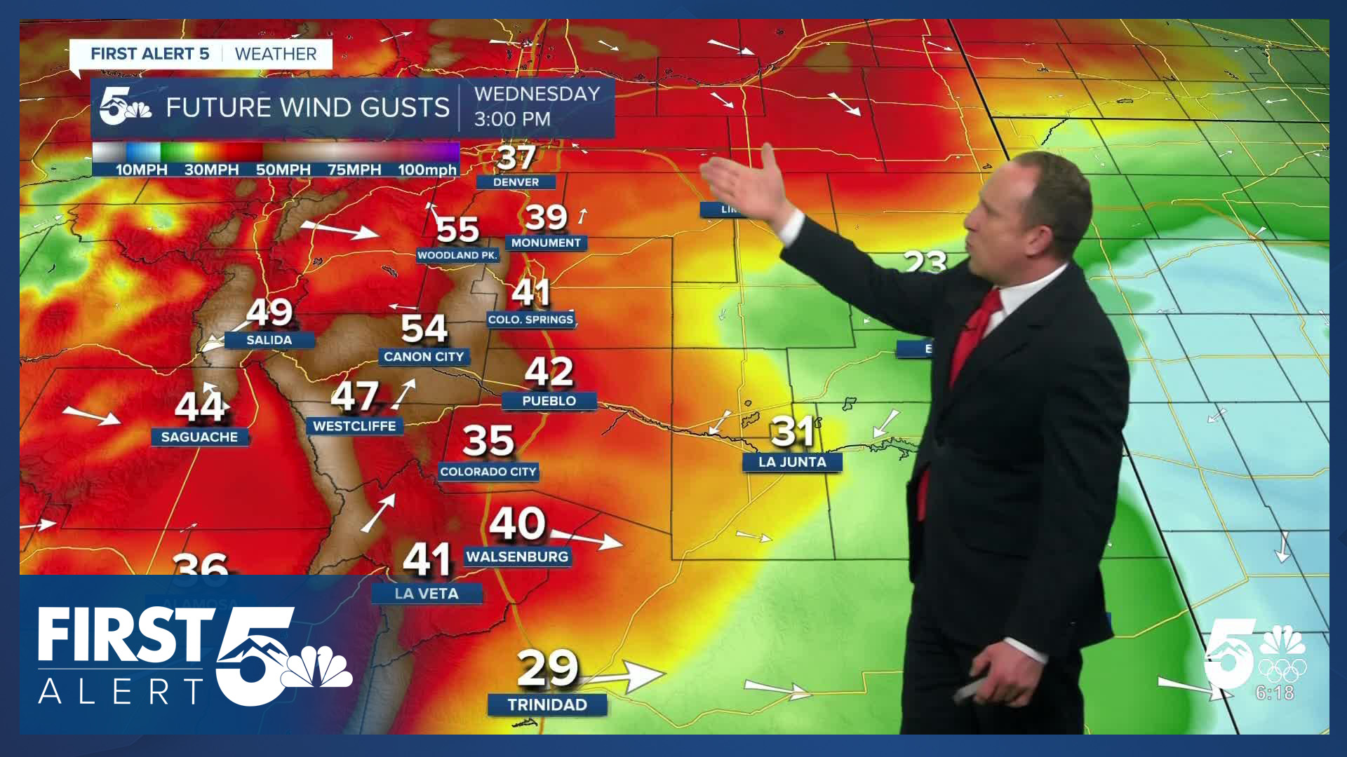
As upper-level high pressure nudges farther south, the jet stream will follow --with the strongest wind corridor moving from the northern mountains, into the central mountains. Expect sustained winds of 20-30 mph in the afternoon, gusting to 40-50 mph. Fire Weather Watches are in place for Wednesday. Highs remain quite warm in the 60s and 70s.
A "cold" front will move south early Thursday, dropping highs back down to the 50s and 60s. Behind the front, it will remain dry, and breezy, but less so than Wednesday. A sprinkle is possible over the Palmer Divide with the front.
In the extended forecast, it's more warmth, more wind, and more dry air. Fire danger remains elevated through at least Friday, with no real chances for moisture until least early next week.
____
Curious about the First Alert 5 Weather Storm Impact Scale? Check out our cheatsheet explainer.
Watch KOAA News5 on your time, anytime with our free streaming app available for your Roku, FireTV, AppleTV and Android TV. Just search KOAA News5, download and start watching.
