


Today’s Forecast:
It will be an active weather day across Colorado. A large area of low pressure is over the Pacific Northwest. Ahead of it, multiple waves of energy will cross through the state, along with elevated jet stream level winds. This combination will result in a mix of severe weather threats, wind, and fire danger across the state.
Saturday morning has begun with comfortable, sunny conditions and mild temperatures. Heading toward noon, clouds will develop in the mountain zones but it will remain mostly sunny along I-25. Temperatures will yet again quickly climb, reaching the low 80s to low 90s today across the plains.
This afternoon, isolated storms will form in the mountains and move into the plains, generally from El Paso county and Teller County north, although Cheyenne, Elbert, and Kiowa counties may also see storms. Any time between 12-6 PM, be on the lookout. While storms will be isolated, if you do happen to get one, it has a high chance of producing strong wind gusts, and small hail.
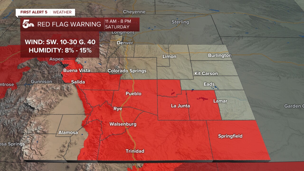
South of highway 50, downslope winds will produce high fire danger today. A Red Flag Warning is in effect from 11:00 AM - 8:00 PM for the Central and Southern mountains, Pueblo and Fremont Counties, and the Southeastern Plains.
Colorado Springs forecast: High: 81; Low: 49.
Colorado Springs is right on the dividing line today, between a dry downslope wind pattern to the south, and much better storm dynamics and moisture to the north. This leads to the threat for very isolated but strong thunderstorms this afternoon. The chance increases the further north you go. This is a set up where you don't need to alter plans for the forecast, but should have an idea of where to go inside if a storm does form in this environment.
Pueblo forecast: High: 91; Low: 53.
RED FLAG WARNING in effect from 11:00 AM - 8:00 PM SAT
FIRE WEATHER WATCH in effect from 10:00 AM - 9:00 PM SUN
Sunny and hot today, with increasing winds out of the south this afternoon. Expect gusts to 30 mph this afternoon along with low humidity.
Canon City forecast: High: 86; Low: 52.
RED FLAG WARNING in effect from 11:00 AM - 8:00 PM SAT
FIRE WEATHER WATCH in effect from 10:00 AM - 9:00 PM SUN
Hot, dry, and breezy today. Southwesterly winds begin to increase late this morning and continue through the afternoon. Expect sustained winds of 10-15 mph, gusting to 25-30 mph at times later today.
Woodland Park forecast: High: 70; Low: 42.
After a fairly pleasant morning, expect increasing clouds after 12 PM with a typical "summer like" pattern of isolated afternoon thunderstorms. Storm chances are highest between 12-6 PM, and again...coverage today is isolated.
Tri-Lakes forecast: High: 70s; Low: 40s.
Sunny this morning, with isolated thunderstorms this afternoon. While isolated, if you do get a storm, it is likely to produce gusty winds (potentially up to 60 mph), and small hail. Have an indoor shelter in mind with your outdoor plans today, and pay attention to the sky.
Plains forecast: High: 90s; Low: 40s/50s.
RED FLAG WARNING in effect from 11:00 AM - 8:00 PM SAT
FIRE WEATHER WATCH in effect from 10:00 AM - 9:00 PM SUN
Sunny, very hot, and breezy. Winds will be southeasterly across the far east plains, and southerly across the southern and south central plains. Gusts of 25-35 mph are possible, and the air will be very dry. Crowley and Kiowa counties north have thunderstorm chances.
Walsenburg and Trinidad forecast: High: 84/87; Low: 53/54.
RED FLAG WARNING in effect from 11:00 AM - 8:00 PM SAT
FIRE WEATHER WATCH in effect from 10:00 AM - 9:00 PM SUN
Sunny with increasing wind this afternoon out of the southwest. Sustained winds will be at 10-20 mph, gusting to 35 mph this afternoon.
Mountains forecast: High: 70s; Low: 40s.
RED FLAG WARNING in effect from 11:00 AM - 8:00 PM SAT
FIRE WEATHER WATCH in effect from 10:00 AM - 9:00 PM SUN
Sunny, warm, breezy, and dry in the southern mountains - with high fire danger. Isolated thunderstorms in the central mountains, Pikes Peak massif, and Rampart Range. In the southern mountains expect southwest winds at 10-20 mph gusting to 40 mph.
Extended outlook forecast:
The incoming energy will cause a surface low to develop late this afternoon in southeastern Colorado. That low will then move into Kansas overnight.
There will again be a chance for isolated storms on Sunday. The surface low from Saturday will help to induce return flow - wet air flow from the Gulf that will wrap around and move into the eastern plains, with an elongated area of low pressure extending into the southeastern tier (a lee side low). Once again storms should be quite isolated, but those that form have the potential to produce strong wind gusts and up to quarter-sized hail. South of Colorado Springs, fire danger will be high again - higher than on Saturday - with stronger wind gusts. It will still be warm with highs in the upper 70s to middle 80s. A cold front will move south on Sunday night.
It will be much cooler Monday due to the cold front as the upper-level system moves into Colorado. Scattered showers and thunderstorms are likely Monday in much of southern Colorado with highs down into the 50s and 60s. A secondary push of cold air will help the front, which is likely to stall out across the plains, swing south on Monday night. This may result in a late season freeze in Colorado Springs Tuesday morning. On average, the last freeze in Colorado Springs is on May 8th. Since 1895, there have been 21 years in which the last freeze was on or after May 19th. Stay tuned to future updates on that forecast.
Isolated storm chances will continue Tuesday through Thursday, as additional upper-level energy swings through Colorado, favoring the mountains and the Palmer Divide. It will remain cool on Tuesday and Wednesday before we begin to warm up again by Thursday.
____
Curious about the First Alert 5 Weather Storm Impact Scale? Check out our cheatsheet explainer.
Watch KOAA News5 on your time, anytime with our free streaming app available for your Roku, FireTV, AppleTV and Android TV. Just search KOAA News5, download and start watching.
