

Today’s Forecast:
The work week will begin much like the weekend ended, warm and dry! Gusts will be strongest across the southern I-25 corridor, where a Red Flag Warning will be in effect from 10 a.m. until 6 p.m. Peak gusts in these areas could top 30-40 mph, with weaker gusts to around 25 mph today closer to Colorado Springs and Pueblo. Highs will be well above average once again on Monday, warming into the 60s and 70s.
Colorado Springs forecast: High: 72; Low: 43. After a record-setting high of 76 degrees on Sunday, we'll only be slightly cooler this afternoon, warming into the lower 70s in Colorado Springs.
Pueblo forecast: High: 76; Low: 38. A warm, dry, and breezy start to the week for Pueblo, with highs today warming into the middle 70s.
Canon City forecast: High: 75; Low: 45. It feels more like May this afternoon than November as we'll see our daytime high warm well into the 70s over eastern Fremont County.
Woodland Park forecast: High: 63; Low: 36. In Teller County, we're looking at a breezy and mild start to our week, with today's daytime high warming into the lower to middle 60s.
Tri-Lakes forecast: High: 60s; Low: 30s/40s. More unseasonably warm weather is on tap for northern El Paso County today, with Monday's forecast more reflective of May than early November.
Plains forecast: High: 70s/80s; Low: 30s/40s. Although we'll be slightly cooler than Sunday, it will remain warm across the Plains on Monday as afternoon highs will climb into the 70s and lower 80s.
Walsenburg and Trinidad forecast: High: 70s; Low: 30s/40s. The southern I-25 corridor will go back under Red Flag Warnings at 10 am, with high fire danger threats remaining a concern until early this evening. Avoid any activities that could start a fire, and if you see smoke, report it to 911.
Mountains forecast: High: 50s; Low: 30s. A windy, but dry start to the week for our southeastern mountains, with gusts at times today up near 45 mph.

Extended outlook forecast:
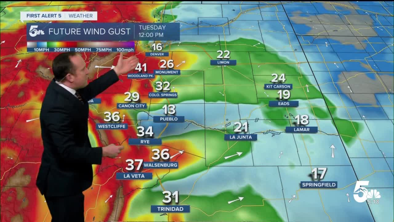
In advance of our next approaching storm system will come a further increase in the wind on Tuesday. Dry, downslope breezes gusting to around 40 mph will bring high fire danger threats back to Southern Colorado on Tuesday, with Fire Weather Watches already being issued for Pueblo County and the southeastern Plains. It will also be warmer on Tuesday, with highs topping out in the 60s, 70s and 80s.
A cold front late Tuesday night will bring a shift to our weather pattern starting on Wednesday, with our highs down by as much as 25-35 degrees late this week. Moisture will increase on Wednesday, with a few rain showers during the day that we think will change to snow by early Wednesday evening. Main impacts from the storm look to arrive Thursday morning, with a few inches of slushy snow possible, making for a tricky commute to work. Snow should clear out by Thursday afternoon, with clearing skies from Friday into the weekend.
____
Curious about the First Alert 5 Weather Storm Impact Scale? Check out our cheatsheet explainer.
Watch KOAA News5 on your time, anytime with our free streaming app available for your Roku, FireTV, AppleTV and Android TV. Just search KOAA News5, download and start watching.
