

Today’s Forecast:
Five of the last seven days in Colorado Springs and Pueblo have broken a daily high temperature record, including setting the new March high temperature records. Today, we do it again: more record heat, as high pressure sits to our south. Today's upper-level airflow will increase in speed in the afternoon as the high pulls further south. These zonal winds will downslope across most of our region this afternoon. Red Flag Warnings will be in place today from 11:00 AM - 8:00 PM. It's important to note that fire danger has been high consistently - Red Flag Warnings are issued when the blend of wind, humidity, and fuel conditions make rapid fire spread likely. Avoid outdoor burning, and activities that can generate sparks.
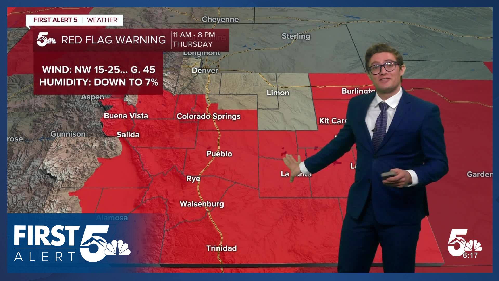
This is the 16th day this March with Red Flag Warnings somewhere in southern Colorado.
While skies will be mostly sunny during the first half of the day, clouds will increase as a cold front approaches this evening. The front will lead to spotty shower chances this evening over the Palmer Divide. Impacts will be low precipitation wise, but you'll notice the cooldown tonight.
Colorado Springs forecast: High: 84; Low: 36.
RED FLAG WARNING in effect from 11:00 AM - 8:00 PM
Mostly clear with patchy smoke from the 24 fire. Today's record high is 81 - and my forecast would comfortably beat that. Skies become partly cloudy in the mid-afternoon, becoming mostly cloudy tonight. A cold front arrives this afternoon. West winds increasing from late this morning to mid-afternoon. By the afternoon, 10-15 mph, gusting 25-30 mph with slightly gustier conditions west of I-25.
Pueblo forecast: High: 90; Low: 37.
RED FLAG WARNING in effect from 11:00 AM - 8:00 PM
H-O-T again today in Pueblo, with high fire danger. Smoke will be visible again from the 24 fire. It will be breezier than yesterday with westerly winds at 10-20 mph in the late morning and 15-25 mph in the afternoon gusting to 35 mph. Ultimately, most of the day will be warm and breezy...but don't forget suncreen if you'll be spending a decent amount of time outdoors. Our UV index is now getting into the high range during mid-day, and you can easily get a sunburn.
Canon City forecast: High: 86; Low: 40.
RED FLAG WARNING in effect from 11:00 AM - 8:00 PM
Another gusty warm day today - with westerly winds at 10-20 mph in the morning, and 15-25 mph in the afternoon gusting to 35 mph. Increasing late afternoon clouds as a cold front arrives. It will become mostly cloudy tonight. A stray overnight sprinkle is possible.
Woodland Park forecast: High: 73; Low: 31.
RED FLAG WARNING in effect from 11:00 AM - 8:00 PM
Mostly sunny and gusty. West winds at 10-20 mph gusting to 40 mph.
Tri-Lakes forecast: High: 70s; Low: 30s.
RED FLAG WARNING in effect from 11:00 AM - 8:00 PM
Mostly sunny and warm with northwest winds at 10-15 mph. Skies become partly cloudy, then mostly cloudy, in the dinnertime period following a cold front. Expect patchy fog on Friday morning which may impact the Friday commute.
Plains forecast: High: 80s/90s; Low: 30s.
RED FLAG WARNING in effect from 11:00 AM - 8:00 PM
HOT once again today with highs in the far east to the mid-90s. Northwest winds at 15-25 mph, gusting to 40 mph this afternoon. Gusts to 45-50 mph possible tonight with the cold front.
Walsenburg and Trinidad forecast: High: 83/87; Low: 37/35.
RED FLAG WARNING in effect from 11:00 AM - 8:00 PM
Sunny, warm, and windy. West winds at 10-20 mph through late morning. In the afternoon, expect winds of 20-30 mph gusting to 35 mph. Skies become partly cloudy tonight, mostly cloudy overnight.
Mountains forecast: High: 70s/80s; Low: 30s.
RED FLAG WARNING in effect from 11:00 AM - 8:00 PM
Gusty, sunny, and warm today with high fire danger. West winds at 10-20 mph, gusting 30-40 mph this afternoon.
Extended outlook forecast:
Friday will begin with clouds, and notably cool temperatures as upslope post-frontal air remains over the I-25 corridor. Fog is possible on Friday morning over the Palmer Divide, and may impact your commute. Otherwise, you can expect mostly cloudy skies Friday with a few morning light sprinkles. Highs will be 30 or more degrees cooler than today's highs! Most areas top out in the 40s - with 30s
We return to heat this weekend, with more record breaking warmth. Skies will be partly cloudy on Saturday and Sunday with highs in the upper 70s to middle 80s. An upper level disturbance will lead to an isolated PM shower chance on Monday north of Highway 50. More unsettled changes will arrive in the middle of the week, with a higher chance of showers and a rumble of thunder by next Wednesday.
____
Curious about the First Alert 5 Weather Storm Impact Scale? Check out our cheatsheet explainer.
Watch KOAA News5 on your time, anytime with our free streaming app available for your Roku, FireTV, AppleTV and Android TV. Just search KOAA News5, download and start watching.
