


Today’s Forecast:
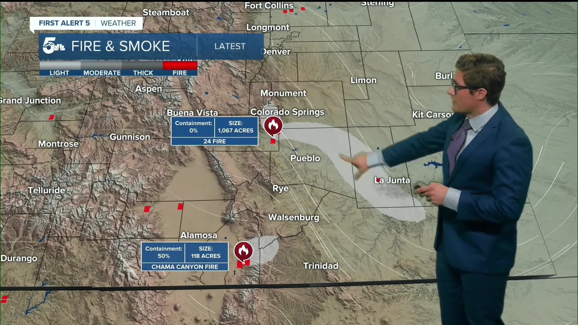
Today's heat will make the last few days seem cool by comparison. By this afternoon, temperatures may rival all-time April warmest levels. Multiple fires are already burning in southern Colorado. Today, high pressure will shift south, allowing stronger wind speeds to overspread the state. These will mix down this afternoon and will result in higher fire danger than we've had over the past several days. Red Flag Warnings go into effect today at 11:00 AM and continue through 11:00 PM: risk remains elevated after sunset. Keep in mind that burn restrictions are in place across El Paso county, independently of Red Flag Warnings. That being said - exercise even more caution today, even outside of areas with active burn restrictions, given the hot, dry, gusty conditions.
We will shatter all-time March high temperature records this afternoon in southern Colorado due to the downslope breeze. Expect mainly sunny skies mixed with haze from wildfire smoke, that smoke likely to be thickest in El Paso county during the afternoon hours, Pueblo County during the morning hours, and some smoke is possible toward Trinidad in mid to late afternoon. Consider indoor exercise this afternoon if you're sensitive to smoke or have any respiratory issues. In addition, if you will be outside - pack plenty of water, electrolytes, and sunscreen. This is a July-like day, so you'll enjoy it most if you pack and prepare accordingly. Highs today will reach the upper 80s in the Pikes Peak Region, 90s in the Arkansas River Valley, and 70s in the mountains.
Wind speeds increase this afternoon along I-25, peaking in the late afternoon to early evening. New grass fires have already cropped up today in southern Colorado w
Colorado Springs forecast: High: 88; Low: 49.
Red Flag Warning in effect from 11:00 AM - 11:00 PM
HOT and hazy. This isn't a close race folks - today's highs will blow the records out of the water. The current March record high is 81 degrees, the April record is 88. We're more looking at April records today. Mainly sunny. Avoid outdoor burning and activities that could start a wildfire. There are burn restrictions in El Paso County.
Pueblo forecast: High: 93; Low: 47.
Red Flag Warning in effect from 11:00 AM - 11:00 PM
Very HOT today! Mainly sunny, with haze from wildfire smoke.
Canon City forecast: High: 91; Low: 52.
Red Flag Warning in effect from 11:00 AM - 11:00 PM
HOT. Drink plenty of water. Haze from wildfire smoke. Increasing wind this afternoon.
Woodland Park forecast: High: 79; Low: 45.
Mostly sunny, and June-like. If hiking, biking, or otherwise planning on being on trails today, plan for muddy conditions particularly in tree-shaded terrain.
Tri-Lakes forecast: High: 80s; Low: 40s.
Red Flag Warning in effect from 11:00 AM - 11:00 PM
Hot, with high fire danger. Increasing afternoon wind gusts.
Plains forecast: High: 90s; Low: 40s/50s.
Significant heat today across the plains - by March standards. Highs will be in the -upper- 90s this afternoon. Please use caution if spending significant time outside and drink plenty of water.
Walsenburg and Trinidad forecast: High: 88/93; Low: 54/51.
Red Flag Warning in effect from 11:00 AM - 11:00 PM
Very hot and mostly sunny. Potential wildfire smoke haze in the afternoon depending on activity of the Chama Canyon fire.
Mountains forecast: High: 60s/70s; Low: 30s/40s.
Red Flag Warning in effect from 11:00 AM - 11:00 PM
Dry, warm, and hazy. Snow, where it is still present, will continue to melt very rapidly.
Extended outlook forecast:
A cold front will swing south overnight - in a pattern that is somewhat similar to last weekend, except this front is drier. It will be breezy Sunday morning following the overnight cold front. But, lows will not drop below freezing across the plains, and highs will still return to the upper 60s to lower 70s in most of southern Colorado on Sunday. This is still about 10 degrees above average. Skies will be partly cloudy.
Monday will remain fairly similar - highs in the low 70s, upper 60s in the higher elevations, and partly cloudy.
Then, our dome of heat returns in the middle of next week. It will not be quite as strong, but it will be sufficient to push highs back into the middle 80s. Due to the more southerly position of the high, stronger upper level wind speeds are also likely which will mix down - meaning fire danger will be high again in the middle of next week.
____
Curious about the First Alert 5 Weather Storm Impact Scale? Check out our cheatsheet explainer.
Watch KOAA News5 on your time, anytime with our free streaming app available for your Roku, FireTV, AppleTV and Android TV. Just search KOAA News5, download and start watching.
