

Today’s Forecast:
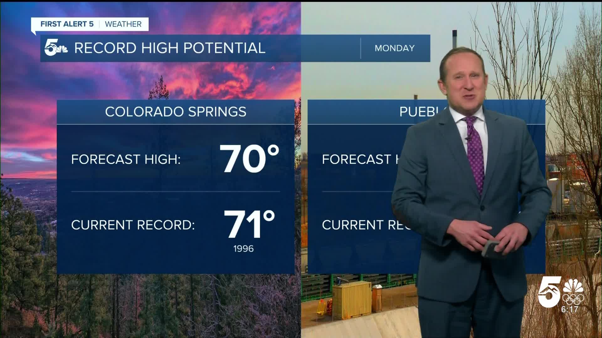
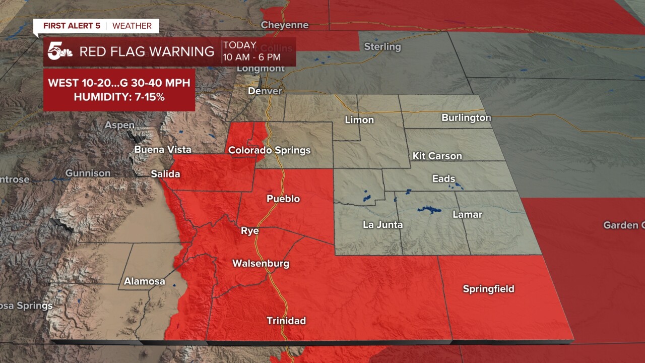
We're on the hunt for record breaking warmth today. The current record high in Colorado Springs is 71° (1996), and 78° (1996) at the Pueblo Memorial Airport. Downslope, dry breezes will help warm the air. Several small grass fires were quickly extinguished yesterday. With more dry air, and gustier breezes today - Red Flag Warnings have been issued in Pueblo County, Teller County, and Fremont County, along with the southern mountains and southeastern plains. El Paso County is not included. However, it will still be dry and breezy today in El Paso County.
In areas under the warning, expect west winds at 10-20 mph gusting 30-40 mph, with humidity values of 7-9%.
Set-up wise, we're being warmed by the slow eastward progression of upper-level high pressure that's been with us since late last week.
Colorado Springs forecast: High: 70; Low: 31. Monday's high of 70 degrees will be around 25 degrees above average. While it will be breezy and dry today, the Colorado Springs metro area will not be included in today's Red Flag Warning. Today's record high is 71° (1996).
Pueblo forecast: High: 75; Low: 28. Our high today in the middle 70s will be as much as 20-25 degrees above average for this time of the year. Today's record high is 78° (1996). A Red Flag Warning will go into effect for Pueblo County starting at 10 am.
Canon City forecast: High: 72; Low: 34. Today's weather will be even warmer than what we saw on Sunday, driven by westerly wind gusts to 30 mph. A Red Flag Warning will remain in effect today in Fremont County from 10 am until 6 pm.
Woodland Park forecast: High: 60; Low: 26. Mid-April temperatures will be on full display this afternoon as highs warm into the upper 50s and lower 60s. Because of gusty west winds and low relative humidity, Teller County will be under a Red Flag Warning today from 10 am until 6 pm.
Tri-Lakes forecast: High: 60s; Low: 20s/30s. It will be warm and breezy on Monday. Although it will be breezy and dry today on Monument Hill, Red Flag Waning conditions are not expected to be met for a long enough period to issue a warning for northern El Paso County.
Plains forecast: High: 70s; Low: 20s/30s. Spring-like warmth, with the potential for near record breaking temperatures this afternoon. Westerly wind gusts will be as strong as 30 mph during the day, with a cold front arriving tonight and gusty north winds for a few hours behind the front.
Walsenburg and Trinidad forecast: High: 60s/70s; Low: 20s/30s. A warm, dry and breezy start to the week will create elevated to critical fire danger today in Huerfano and Las Animas counties, with a Red Flag Warning in effect from 10 am until 6 pm.
Mountains forecast: High: 40s/50s; Low: 20s. Strong westerly wind gusts and low relative humidity in the single digits and teens will result in Red Flag Warnings today in the southeastern mountains. Areas with snow on the ground will see less of a threat than areas where dry fuels can be found.
Extended outlook forecast:
A cold front will whoosh in early Tuesday well before sunrise and high temperatures fall to the upper 40s and 50s as a result. It'll be breezy when the front passes by with some 30 mph gusts. This is a dry front for Southern Colorado, but it will bring our northern mountains some snow. You'll notice another day with periodic mid-level clouds. You'll also feel the chilly breeze behind that front with southeasterly afternoon winds, though they won't be as strong as the wind with the front itself...more in the 10-20 mph range.
A swing back to downslope flow warms temps back up Wednesday, and also means Wednesday morning may not be all that chilly. Highs will be in the 60s again on the Plains. By Wednesday evening, an upper level disturbance will approach. It will be windy in the southern mountains. If you'll be driving on US 160 Wednesday, be on the watch for downed branches or debris on La Veta Pass. This incoming disturbance will result in snow across the Northern, San Juan and Central mountains which ramps up through the day. By Thursday morning, light snow will move into the southern mountains.
On Thursday, a large plume of moisture swings into the state and mountain snow will continue. By the afternoon, upslope flow will develop across southeastern Colorado. This will result in spotty rain, mix, and snow showers during the afternoon and evening in the Pikes Peak Region. Highs will be in the mid to upper 50s.
Overnight, these spotty showers change to a wintry mix. On Friday, energy from a southerly tracking system brings more rain and snow shower chances to the area. This should wrap up this weekend.
____
Curious about the First Alert 5 Weather Storm Impact Scale? Check out our cheatsheet explainer.
Watch KOAA News5 on your time, anytime with our free streaming app available for your Roku, FireTV, AppleTV and Android TV. Just search KOAA News5, download and start watching.
