


Tonight's Forecast:
Snow will spread into the mountains tonight, with Winter Weather Advisories and Winter Storm Warnings in effect for areas along and west of the Continental Divide. The San Juans could get hit really hard over the next 12-24 hours, with as much as 2 feet of snow in some areas.
For the I-25 corridor and Plains, we're looking at a mostly cloudy and cool night, with lows only dropping down to the 20s and 30s.
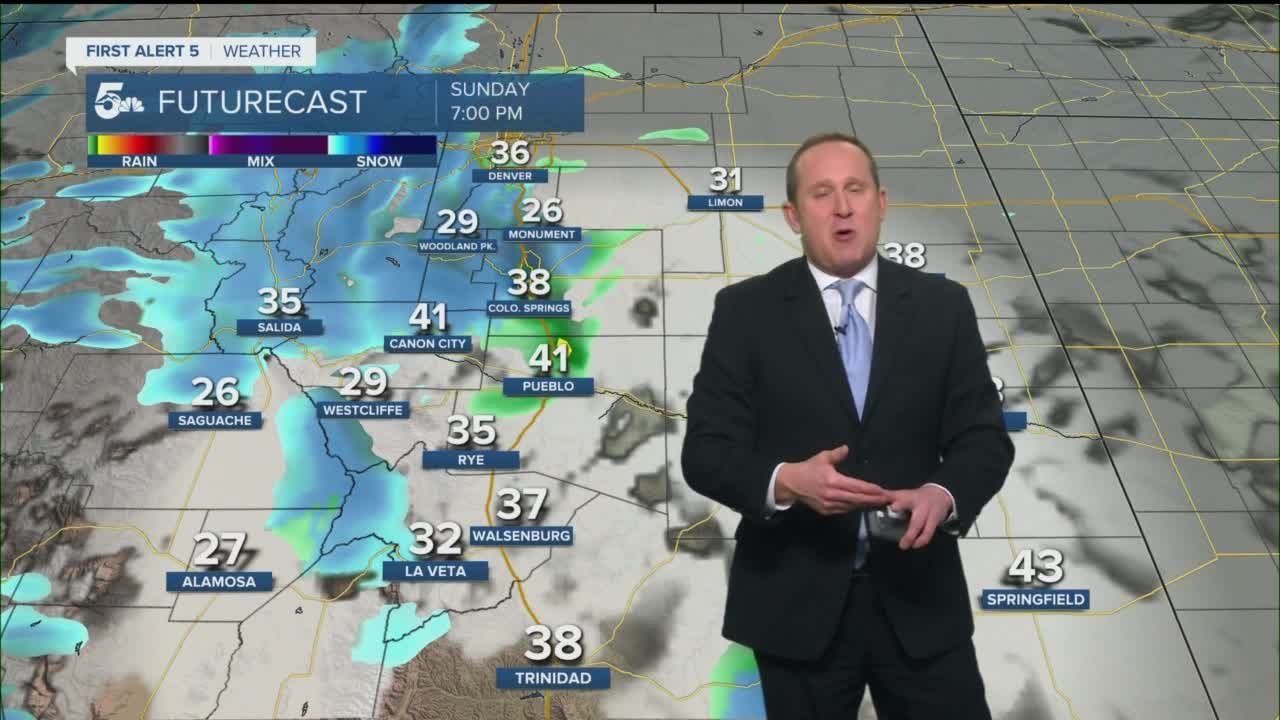
Colorado Springs forecast: Low: 32; High: 50; While we'll still be above average on Sunday, we can expect a good 10-15 degree cool down from what we saw today. A weak storm will clip the Pikes Peak Region Sunday evening, and bring with it the potential for a light dusting of snow.
Pueblo forecast: Low: 30; High: 58; Windy and cooler on Sunday, with the potential for a few evening flurries or sprinkles. That said, accumulations are not expected for our area.
Canon City forecast: Low: 33; High: 55; Mostly cloudy skies and cooler highs on Sunday, but even with the cool down, we'll still be above average for this time of the year. While precipitation can't completely be ruled out, the chance for a passing evening rain or snow shower only sits at around 20%.
Woodland Park forecast: Low: 25; High: 41; Turning unsettled in Teller County by Sunday afternoon/evening as storm energy looks to exit the mountains and bring a quick burst of snow to our forecast. Snow totals from a trace-2".
Tri-Lakes forecast: Low: 20s/30s; High: 40s; As storm energy looks to exit the mountains late in the day on Sunday, we're looking at the potential for a quick burst of snow over the Palmer Divide. Snow totals from a trace-1".
Plains forecast: Low: 20s/30s; High: 50s/60s; After a warm start to the week, a modest cool down can be expected for the Plains on Sunday, along with gusty westerly winds and the potential for a few sprinkles or snow flurries.
Walsenburg and Trinidad forecast: Low: 20s/30s; High: 40s/50s; The wind will remain a factor in our forecast again on Sunday, with westerly wind gusts ranging between 40-45 mph across the southern I-25 corridor.
Mountains forecast: Low: 10s/20s; High: 20s/30s; A storm blowing into the mountains on Sunday will bring snow and strong winds to the Sangres, with up to 5" of accumulation in some areas, and little to no accumulation for the Wet Mountains. The heaviest snow through Sunday night will impact the San Juans, where a Winter Storm Warning remains in effect until 11 pm.
Extended outlook forecast:
MLK Day on Monday will be a mostly sunny and breezy one for Southern Colorado, with highs in the Plains topping out in the 40s and 50s. A much larger and more impactful storm will follow from Tuesday to Wednesday. Although it's still too early to nail down exact storm totals, early model data is lining up for a 2-5" storm for the Pikes Peak Region, with higher totals possible up towards Teller County and Monument Hill. For now, we're concerned with the Tuesday evening and Wednesday morning commutes.
The storm should clear out by Wednesday afternoon, but will be followed by another chance for snow for Southern Colorado come Friday.
____
Curious about the First Alert 5 Weather Storm Impact Scale? Check out our cheatsheet explainer.
Watch KOAA News5 on your time, anytime with our free streaming app available for your Roku, FireTV, AppleTV and Android TV. Just search KOAA News5, download and start watching.
