

Today’s Forecast:
Upslope flow in place yesterday afternoon led to mid-level clouds and highs reached early in the day, courtesy of a weak cold push associated with upper level energy north of Colorado. Tuesday begins with clear skies in Southern Colorado, with another weak northerly upper-level system beginning to move into the state. Temperatures are starting about 10-15 degrees cooler than yesterday with readings in the 10s and 20s.
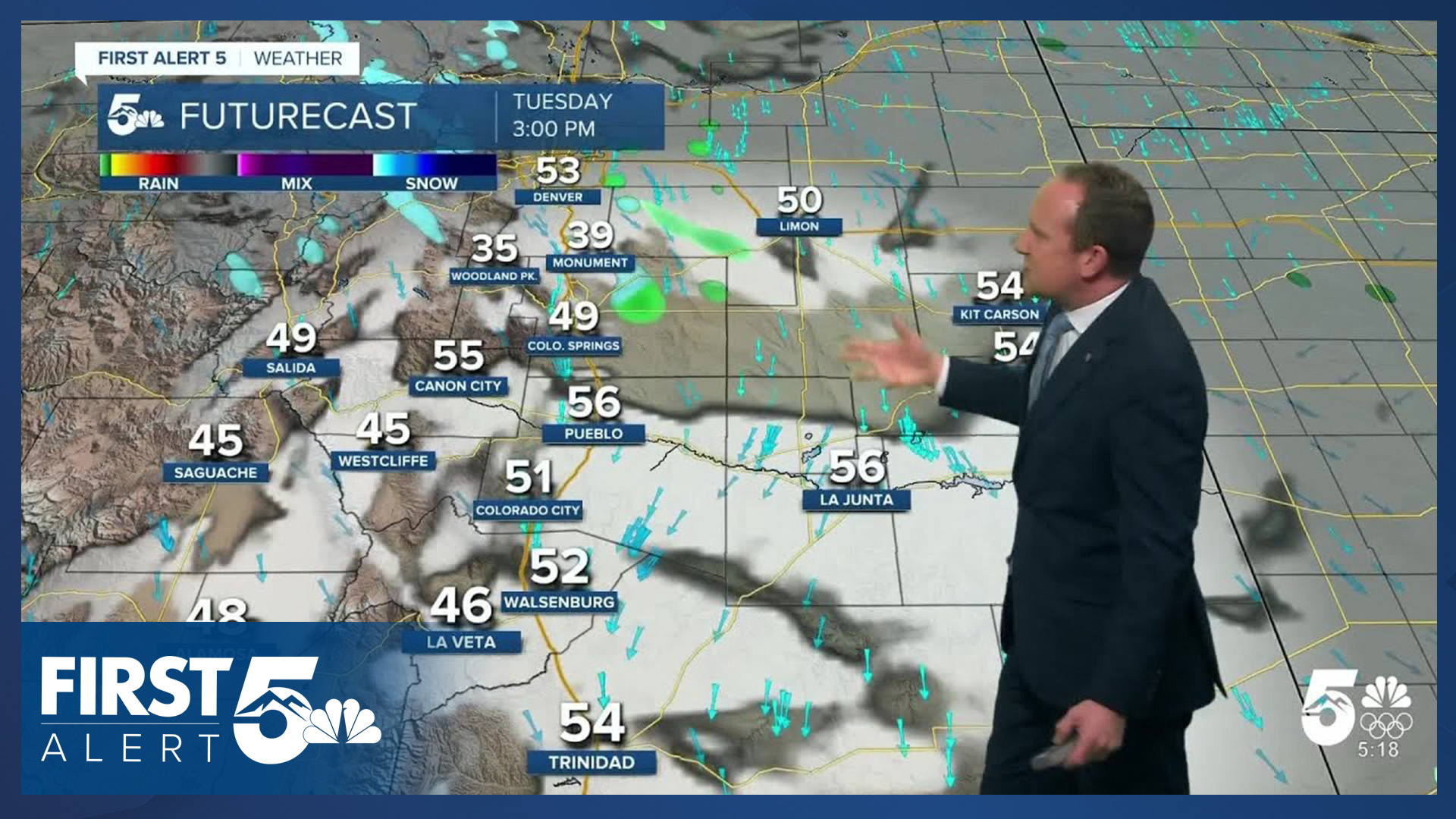
We'll still warm up nicely today though with temperatures climbing to the 50s this afternoon on the southeastern Plains. This is partly due to downslope wind ahead of the incoming system that will push a cold front through the area. You can expect 15-20 mph sustained winds over Monument Hill this afternoon, with gusts to 35 mph. Across much of the rest of the Pikes Peak Region sustained winds will be in the 10-20 mph range, gusting to 30 mph this afternoon.
Clouds will move in from the north this morning and continue to move in and out this afternoon. While this system doesn't have a lot of moisture, it does have some. As energy reaches the Palmer Divide in the mid to late afternoon, light rain and snow showers will be possible. This may mildly impact the evening commute but the overall effects are low at best. Precipitation is less likely in Colorado Springs itself, other than some flurries and possible a trace of snow on grassy surfaces. Winds will quickly diminish after sunset. We could also see some snow form this evening around the Raton Mesa Region.
Colorado Springs forecast: High: 51; Low: 25. Our second cold front of the week will bring another round of 25-35 mph wind gusts to the Pikes Peak Region this afternoon. Along with the wind, there could be a few isolated to spotty rain and snow showers this evening. Snow totals under 0.5" in Colorado Springs.
Pueblo forecast: High: 56; Low: 22. Highs will be cooler today than the past days, with another cold front bringing gusty wind to our forecast and only around a 10% chance of a rain or snow shower this evening.
Canon City forecast: High: 57; Low: 25. Even with a cool down of around 3-6 degrees from yesterday, temperatures will remain above average for this time of the year. A quick moving front will bring gusty wind to our forecast today, along with a very small chance of a few snow flakes this evening.
Woodland Park forecast: High: 42; Low: 18. Today's forecast will start to look and feel more like early February as our cold front brings additional cooling to the forecast today and more gusty wind. Light snow showers will be possible this afternoon and evening, with up to 1" of accumulation.
Tri-Lakes forecast: High: 40s; Low: 20s. An incoming cold front will bring gusty wind to our forecast on Tuesday and the potential for some light snow showers this afternoon and evening. Accumulations are expected to remain at or under 1".
Plains forecast: High: 50s; Low: 10s/20s. Another cold front, our second of the week, will arrive this afternoon with more wind than moisture for the eastern Plains. Wind gust to 30 mph will be possible in some areas.
Walsenburg and Trinidad forecast: High: 40s/50s; Low: 10s/20s. Further cooling can be expected on Tuesday as our latest cold front drops in from the north. Northerly wind gusts will be up around 30 mph today, and along with the wind, there's a slight chance for snow near the Raton Mesa this evening.
Mountains forecast: High: 20s/30s; Low: 10s. Mostly clear skies this morning will give way to a windy afternoon, with increasing clouds across the mountains as more storm energy spills into Colorado from the north. While a few inches of snow will be possible in the central and northern mountains, less than 1" is expected in the southeastern mountains.
Extended outlook forecast:
We will briefly cool down on Wednesday to seasonal highs in the middle 40s to lower 50s with mainly sunny skies following tonight's system. Then, we return to what has been the theme of the winter: a dominant ridge of high pressure moves back over the Intermountain West, and we get warm. Highs Thursday through Saturday will be in the 60s. We will keep an eye on potential fire weather concerns as the ridge breaks down this weekend.
By Sunday, we're a bit cooler as the state sits between storm paths - one well north of Colorado, the other south. A possible pattern change to cooler and unsettled weather remains possible towards the middle of next week.
____
Curious about the First Alert 5 Weather Storm Impact Scale? Check out our cheatsheet explainer.
Watch KOAA News5 on your time, anytime with our free streaming app available for your Roku, FireTV, AppleTV and Android TV. Just search KOAA News5, download and start watching.
