


Tonight's Forecast:
Most of the heavier snow will fall between 6 pm Sunday and 6 am Monday. The far eastern Plains will be under a Winter Weather Advisory during the overnight hours, with all other areas under a Winter Storm Warning. Heavy snow bands are likely to set up during the overnight hours, which will greatly reduce visibility and could make travel difficult to impassable for brief periods of time. As for temperatures, it will be bitterly cold across Southern Colorado, with wind chill values expected to be as cold as -10 degrees in some areas.
Regional Snow Forecast
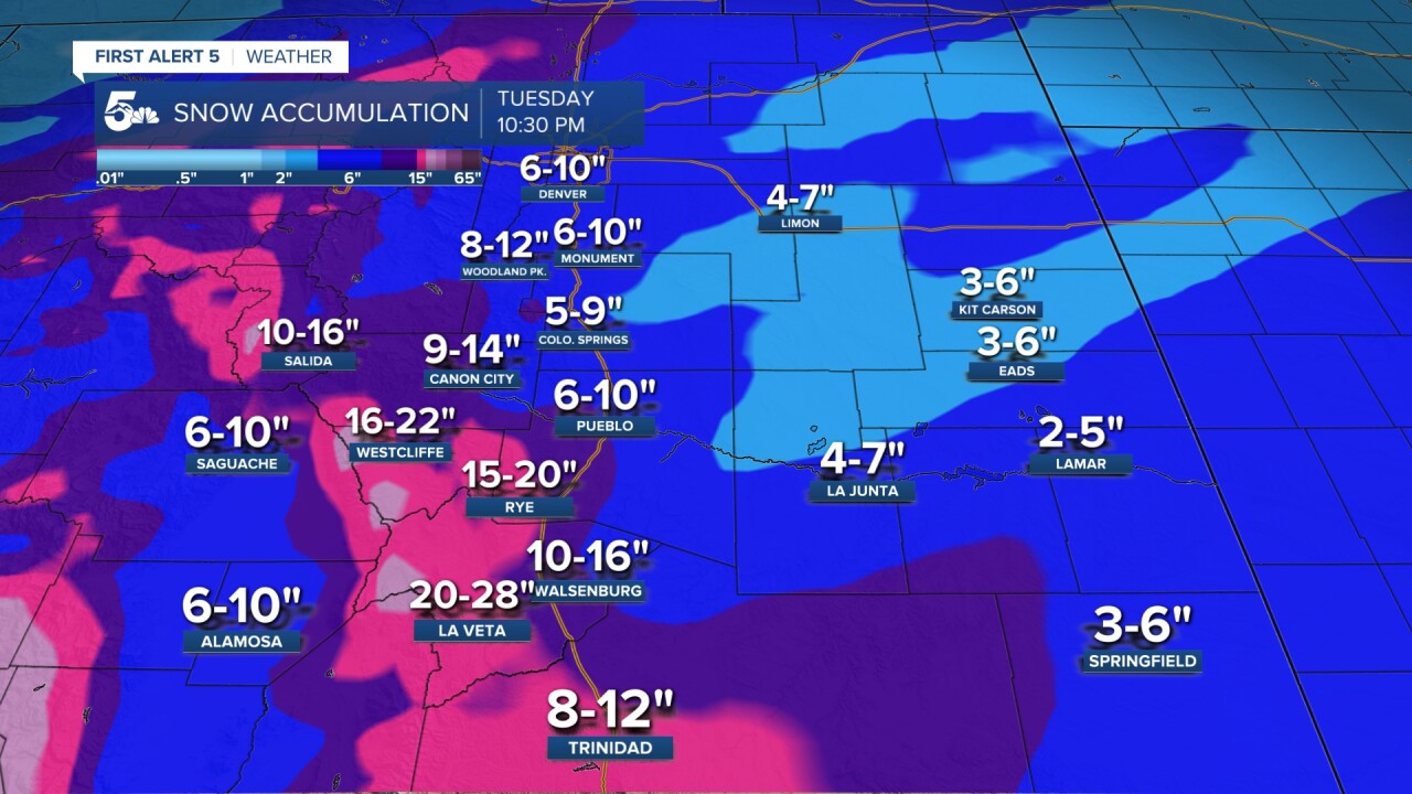
COLORADO SPRINGS: Low: 4; High: 16. Snow early Monday will taper off to flurries by the lunch hour. The morning commute will be messy across the metro area as 5-9" of snow will be possible by around sunrise Monday. Expect snowpacked and icy streets, especially on untreated roadways. Highs on Monday will only warm into the teens.
PUEBLO: Low: 12; High: 17. Cold and snowy in the morning, with snow showers tapering off by the afternoon. Snow totals in town could range between 6-10", with higher amounts for Pueblo West.
CANON CITY: Low: 13; High: 17. A Winter Storm Warning will remain in effect in the Canon City area until noon Monday. Most of the snow should taper off in Fremont County by the afternoon as we'll be left with a cold day, and an even colder night.
WOODLAND PARK: Low: 0; High: 14. The work week will start out bitterly cold and snowy across Teller County. Most of the snow should come to an end by the lunch hour, with lows falling to near 0 degrees by Monday night.
TRI-LAKES: Low: -0s/0s; High: 10s. Cold, breezy and snowy on Monday, with a Winter Storm Warning in effect until noon. Dry skies will move back in late Monday afternoon, setting the stage for a bone-chilling night across northern El Paso County.
PLAINS: Low: 0s/10s; High: 10s/20s. Cold and snowy on Monday, with a Winter Weather Advisory in effect until 6 pm. I think that the snow will slowly start to wind down by early to mid afternoon, with a dry and cold night expected to follow.
WALSENBURG/TRINIDAD: Low: 0s; High: 10s. Winter Storm Warnings are now in effect through 6 pm Monday. Walsenburg is expecting anywhere between 10-16" of snow, while Trinidad could pick up between 8-12".
Extended Outlook:
Tuesday morning will be bitterly cold, with the potential for record lows in some areas. Highs will moderate some on Tuesday compared to Monday, but it will still be quite chilly. The system responsible for the snow and cold Sunday and Monday will move south of the area early next week before ejecting east on Wednesday. It's possible that as the system moves away some snow or rain will push back into parts of Southern Colorado. For now, the best chances of seeing additional precipitation next Wednesday will be across the southeast Plains. Highs will be slow to climb until the storm moves away. Once it does, 60s will return by Halloween.
