


Disclaimer: This is sponsored content. All opinions and views are of Monarch Mountain and does not reflect the same of KOAA.
Colorado ski resorts are preparing for what - for some of them - could be the best storm of the season so far, with fresh powder blanketing the slopes over the next several days.
Currently, most ski area base depths are running between 20 and 50 inches. The higher base depths can be found at Aspen, Silverton Mountain, Steamboat, Vail, Crested Butte, and Wolf Creek. Ski operation teams have done an impressive job of getting terrain open this month given the conditions - but mother nature is ready to lend a hand now.
SKI AREA SNOW FORECAST
Snow will expand across the western and central mountains Friday morning, with moderate to heavy rates at times.. Aspen, Vail and Crested Butte are likely to see some of the best early accumulations by Friday afternoon.

The snow will continue overnight into Saturday morning before gradually decreasing in intensity during the afternoon. Temperatures will be frigid, with highs in the teens and negative wind chills - and that's assuming you're not moving and adding to the wind velocity on your skin.

After a brief clearing period early Sunday, additional snow showers are likely across the northern mountains through mid-afternoon due to northwesterly airflow and energy.
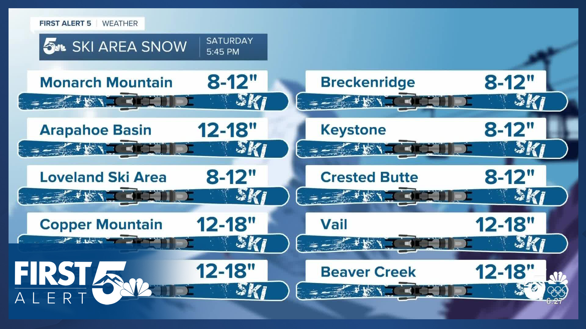
This multi-day powder event could deliver a foot of snow to many resort upper slopes by the end of the storm.

One reason I'm so bullish on the ski area totals is the shear coldness of the upper-level air. When the air is colder, the rain: snow ratio goes up. So we're likely going to get ratios in the 1:20+ range. That translates to light, fluffy, dry powder snow that Colorado is famous for.
At the beginning of the event air temperatures will still be fairly warm and the snow will be wetter, but the falling snow tends to lower the air temperature and increase the dew point. Ultimately as additional arctic cold air gets pushed in early Saturday, the remaining snow will become increasingly air-filled.
MAIN TAKEAWAYS

Winter weather alerts are active in the mountains from Friday through Sunday. If you're aiming to ski the new powder, you should plan for difficult travel conditions with potential road closures and dress for the coldest air of the season. Don't underestimate it.
The best travel times will be Thursday night, and Sunday morning - before the storm arrives, and after the main energy clears.
The storm is very likely to open new terrain at resorts, and existing runs will ski significantly better thanks to improved base depths for the next week. Although trail conditions will be best on Saturday and on Sunday morning, you'll still have dramatically less blue ice and other lack-of-recent-snow concerns even if you don't ski until mid-week.
This is precisely the storm Colorado ski areas have needed for months. Those planning to hit the slopes should be prepared for intense arctic cold and extremely difficult travel conditions due to both snow and high traffic.
__
Watch KOAA News5 on your time, anytime with our free streaming app available for your Roku, FireTV, AppleTV and Android TV. Just search KOAA News5, download and start watching.
