


Tonight's Forecast:
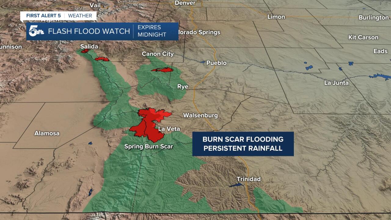
Big storm complex will bring heavy rain, thunderstorms, hail and lightning to Southern Colorado tonight. Heaviest storms will continue to line up for area south of El Paso County and the Pikes Peak Region. More than an inch or rain will fall in some areas by Tuesday morning, generally along and south of Highway 50. Big concern will also be across the recent burn scars, foothills and mountains. Flash Flood Watches will continue until midnight tonight. After midnight, areas of rain will persist, but should lessen in intensity during the overnight hours.
COLORADO SPRINGS: Low: 45; High: 60. Cloudy, cool and unsettled with periods of rain on Tuesday across the Pikes Peak Region. Severe thunderstorms are not expected.
PUEBLO: Low: 48; High: 66. Cool highs and cloudy skies for the Pueblo area on Tuesday, with more rain possible. Thunderstorm threat will be lower, but still can't be ruled out completely from the forecast.
CANON CITY: Low: 48; High: 64. Wet, spring weather will continue on Tuesday, with periods of rain and isolated thunderstorms in the forecast by the afternoon.
WOODLAND PARK: Low: 36; High: 54. Wednesday will be jacket weather for Teller County as it'll be cool, cloudy and wet at times. It's possible that some snow could mix in with the rain by Tuesday night.
TRI-LAKES: Low: 30s/40s; High: 50s. It'll be a cool and gray afternoon across northern El Paso County on Tuesday. Rain showers and isolated thunderstorms will be possible during the day, but severe weather is not expected.
PLAINS: Low: 40s; High: 60s/70s. Scattered thunderstorms will be possible across the Plains again on Tuesday, with the main severe weather threat expected for the far southeastern corner of the state.
WALSENBURG/TRINIDAD: Low: 40s; High: 60s. More beneficial chances for precipitation in the forecast on Tuesday, and although we'll likely see rain in the afternoon, severe storms are not expected.
MOUNTAINS: Low: 20s/30s; High: 30s/40s. Snow levels will be dropping in the mountains on Tuesday, with accumulating snowfall above 9,000 to 10,000 feet. Along with the snow, we could see some thunderstorms and heavy downpours.
Extended Outlook:
A few more sun breaks will be possible by Wednesday, with scattered afternoon thunderstorms across parts of Southern Colorado. Drier and warmer weather is expected on Thursday, but it might not last long as another storm pushes into the Great Basin by Friday and Saturday. This storm will battle with a ridge of high pressure to our east, but could still send some showers and thunderstorms into the forecast on both Friday and Saturday.
KOAA News5 on your time, streaming on your Roku, FireTV, AppleTV and AndroidTV.
News5 App | First Alert 5 Weather App | Youtube | Facebook | Instagram | Twitter
