


Today’s Forecast:
Today will be cloudy with light winds in the plains with more sunshine in the mountains. Temperatures will be cool and comfortable today.
We're always streaming with KOAA News 5 on your Roku, FireTV, AppleTV or Android TV.
Scroll down for Saturday and Sunday snow forecasts and timing details.
COLORADO SPRINGS: High: 38; Low: 30. Staying partly to mostly cloudy today. A stray rain shower is possible this evening in eastern El Paso county.
PUEBLO: High: 44; Low: 32. Clouds today with a chance of rain this evening, increasing in potential tonight.
CANON CITY: High: 42; Low: 26. Partly cloudy and comfortable today and staying dry.
WOODLAND PARK: High: 40; Low: 26. Cool and sunny today with the winter storm warning going into effect at 11 pm.
TRI-LAKES: High: 30s; Low: 20s. Upper 30s with clouds and light wind today.
PLAINS: High: 40s; Low: 30s. Mid 40s with clouds today and a chance of rain this evening and tonight, with isolated lightning possible.
WALSENBURG/TRINIDAD: High: 40s/50s; Low: 20s/30s. Highs in the 40s in Walsenburg and 50s for Trinidad with partly cloudy sky conditions.
MOUNTAINS: High: 40s; Low: 20s. Low 40s with sunshine and light winds today, snow moves in late tonight.
Weekend Snowstorm:
Storm timing is a bit delayed compared to yesterday's data. Some snow will start late tonight, most will accumulate from Saturday afternoon through early Monday morning. Some zones may start as rain or a mix of rain and snow, especially along the I-25 corridor (see graphic below). A transition to snow is expected by Saturday night or Sunday at the latest, for the I-25 corridor. The eastern plains will stay as rain during this event, picking up widespread 0.5" up to 1" in isolated spots.

Winds will be very strong on Sunday, with frequent gusts 30-40 mph and gusting 40-50 mph at times, which will cause blowing snow and reduced visibility.
Southern Colorado region snow totals (updated Friday morning):
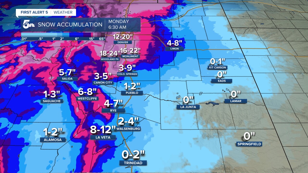
Pikes Peak region snow totals:

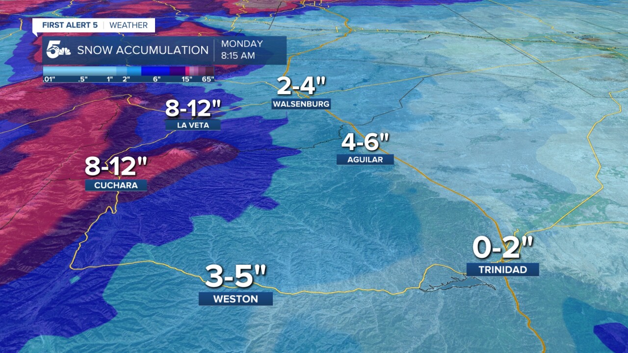
Arkansas River and Wet Mountains snow totals:
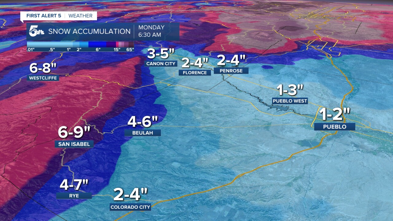
Southern I-25:
Track the storm in real time, including snow totals and updated forecasts, on the First Alert 5 Weather stream, which can be viewed on the KOAA News5 app or here:
KOAA News5 on your time, streaming on your Roku, FireTV, AppleTV and AndroidTV.
News5 App | First Alert 5 Weather App | Youtube | Facebook | Instagram | Twitter
